
The Emily Dickinson Museum is a historic house museum consisting of two houses: the Dickinson Homestead and the Evergreens. The Dickinson Homestead was the birthplace and home from 1855–1886 of 19th-century American poet Emily Dickinson (1830–1886), whose poems were discovered in her bedroom there after her death. The house next door, called the Evergreens, was built by the poet's father, Edward Dickinson, in 1856 as a wedding present for her brother Austin. Located in Amherst, Massachusetts, the houses are preserved as a single museum and are open to the public on guided tours.

The Amherst Central Business District is a historic district encompassing the heart of downtown Amherst, Massachusetts. Centered on the northern section of the long town common, the area has been the civic and commercial heart of the town since the 18th century. The district was listed on the National Register of Historic Places in 1991, and slightly enlarged in 2011.

Athens is a small unincorporated village in the rural services area of Lexington-Fayette Urban County to the east of Interstate 75 in Kentucky in the United States. First settled in 1786 as the community of Cross Plains, the town was chartered as Athens in 1826 and had its own post office from that time until 1906. The current commercial center was reduced to its present size by a series of fires in the mid-19th century.

The Sheffield Plain Historic District encompassing the original 18th-century village center of Sheffield, Massachusetts. The linear district extends southward about 0.5 miles (0.80 km) from the junction of United States Route 7 and Cook Road, where the original town common is located. The district was primarily developed in the mid-18th and early 19th centuries. It was listed on the National Register of Historic Places in 1988.

The East Village Historic District is a historic district encompassing the center of the East Village of Amherst, Massachusetts. It includes properties on Main Street, North East Street, and South East Street. The village was one of Amherst's principal civic and commercial centers until the arrival of the railroad in Amherst Center in 1853, and remained a primarily residential area thereafter. The district was listed on the National Register of Historic Places in 1986.

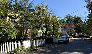
The Lincoln–Sunset Historic District is a residential historic district located west of the downtown area of Amherst, Massachusetts. Colloquially known as Millionaire's Row, the district extends along Lincoln and Sunset Avenues between Northampton Street and the campus of the University of Massachusetts, Amherst. This area was one of Amherst's first planned residential subdivisions, and features a large number of high-quality houses, built by merchants, businessmen, and academics. It was added to the National Register of Historic Places in 1993.
The Prospect—Gaylord Historic District is a historic district encompassing a residential area built up mostly in the late 19th century just outside the central business district of Amherst, Massachusetts. Contributing properties include most of the houses on Prospect Street, which parallels Pleasant Street, as well as properties on Gaylord and Amity Streets running west from Prospect. These houses are generally in late Victorian styles such as Queen Anne, although some, for example a workman's house at 24 Gaylord Street, are in a more vernacular style. A central element of the district is the Hope Community Church, a historically African American church built in 1912 for a congregation whose history dates to 1869. Funds for its construction were raised in part through the efforts of W.E.B. Du Bois. The district was listed on the National Register of Historic Places in 1993.

The Bradford Common Historic District is a historic district encompassing the former town center of Bradford, now a village of Haverhill, Massachusetts. Centered on the former town common at South Main and Salem Streets, the area served as Bradford's civic and commercial center from about 1750 until its annexation by Haverhill in 1897, and retains architecture from the 18th to early 20th centuries. It was added to the National Register of Historic Places in 1977.

The Downtown North Historic District is a 19-acre (7.7 ha) historic district in Hartford, Connecticut. It is a predominantly residential area located around Main Street and High Street north of I-84 and south of the Amtrak railroad tracks. Its apartment blocks, houses, schools and churches, built up mainly in the late 19th and early 20th centuries as part of an expansion of the city's urban core. It includes the 130-foot (40 m) Keney Tower. The area was listed on the National Register of Historic Places in 2004.

Entranceways at Main Street at Lamarck Drive and Smallwood Drive are a set of complementary residential subdivision stone entranceways built in 1926. They are located on Main Street in the hamlet of Snyder, New York within the town of Amherst, which is located in Erie County. These entranceways are markers representing the American suburbanization of rural areas through land development associated with transportation on the edges of urban developments. The Smallwood entranceway is a pair of symmetric groupings of stone gatehouses and posts flanking the two sides of the drive at Main Street. The Lamarck entranceway is a pair of Y-shaped and U-shaped stone half-walls flanking the two sides of the drive at Main Street. The entranceways were added to the National Register of Historic Places on December 7, 2005.

Entranceway at Main Street at Roycroft Boulevard is a suburban residential subdivision entranceway built in 1918. It is on Main Street in the hamlet of Snyder, New York, in the town of Amherst within Erie County. The entranceway is a marker that represents the American suburbanization of rural areas, suburbanization that occurred through transportation-related land development on the edges of urban areas. It consists of a variety of half-height wall formations, featuring a semicircular wall on the Roycroft Boulevard median's intersection with Main Street. The entranceway was added to the National Register of Historic Places on December 7, 2005.

The Front Street Historic District in Exeter, New Hampshire, encompasses a portion of the town's historic center. The district extends from Swasey Pavilion, at the junction of Front and Water streets, southwesterly along Front Street to Gale Park, about five blocks. Front Street is one of Exeter's oldest roads, and is lined with a series of 18th and 19th-century civic, religious, and residential structures, many of which are well preserved. The district was listed on the National Register of Historic Places (NRHP) in 1973.
The Chelsea Parade Historic District encompasses a predominantly residential area north of downtown Norwich. Centered around the Chelsea Parade, a triangular public park, the area has long been a preferred residential area for the city's upper classes, and includes a catalog of architecture from the 18th to 20th centuries. It includes 565 contributing buildings, two other contributing sites, and six contributing objects over an area of 205 acres (83 ha). The district was listed on the National Register of Historic Places in 1989.

The Amherst Village Historic District encompasses the historic village center of Amherst, New Hampshire. Centered on the town's common, which was established about 1755, Amherst Village is one of the best examples of a late-18th to early-19th century New England village center. It is roughly bounded on the north by Foundry Street and on the south by Amherst Street, although it extends along some roads beyond both. The western boundary is roughly Davis Lane, the eastern is Mack Hill Road, Old Manchester Road, and Court House Road. The district includes the Congregational Church, built c. 1771-74, and is predominantly residential, with a large number of Georgian, Federal, and Greek Revival houses. Other notable non-residential buildings include the Farmer's Bank, a Federal-style brick building built in 1806, and the Amherst Brick School, a brick Greek Revival structure that now serves as a community center.
The Stephen Miller House, also known as the Van Wyck-Miller House, is located along the NY 23 state highway in Claverack, New York, United States. It is a wooden farmhouse dating from the late 18th century.
The Canton Center Historic District encompasses the historic rural town center of Canton, Connecticut. Extending mainly along Connecticut Route 179, near the geographic town center, is a well-preserved example of a rural agricultural center in Connecticut, a role served until about 1920. The district includes many examples of Late Victorian and Greek Revival architecture. It was listed on the National Register of Historic Places in 1997.
The Grant Road Historic District is located in the Tenleytown neighborhood of Washington, D.C.. The two-block historic district is what remains of a former settlement in rural Washington County in the District of Columbia. It includes 13 contributing buildings and the road itself, a narrow remnant of a country road that was used by soldiers in the Civil War. Following the war, the road was named after Civil War general and President Ulysses S. Grant. Grant Road developed into a residential street lined with mostly small, two-story homes for working-class people.

The Town Center Historic District encompasses the historic village center of South Hampton, New Hampshire. Centered around the Barnard Green, the town common, on New Hampshire Route 107A, it includes architectural reminders of the town's growth and change over time. The district was listed on the National Register of Historic Places in 1983.

The West Brattleboro Green Historic Districts encompasses the historic core of the village of West Brattleboro, Vermont. Centered in the triangular green at South Street and Western Avenue, it includes a modest collection of buildings constructed between about 1800 and 1910. It was listed on the National Register of Historic Places in 2002.

The Pomeroy Terrace Historic District is a historic district on the east side of downtown Northampton, Massachusetts. Located south of Bridge Street east of the main railroad right-of-way, it was one of the city's most desirable residential neighborhoods of the 19th century, retaining many fine examples of residential architecture from that period. It was listed on the National Register of Historic Places in 2018.


