The John Whipple House is a historic colonial house at 1 South Green in Ipswich, Massachusetts. Built in the seventeenth century, the house has been open to the public as a museum since 1899 and was the subject of some of the earliest attempts at the preservation of colonial houses. It was designated a National Historic Landmark in 1960, one of the earliest properties to receive that honor.

The Gardner Uptown Historic District is a historic district encompassing the former civic heart of Gardner, Massachusetts. The 65-acre (26 ha) area includes the old town common, an early cemetery, and a modest number of non-residential buildings among a larger number of houses. The area was the center of civic life from the incorporation of Gardner in 1785 until municipal functions were moved to West Gardner beginning in the late 1920s. The district was listed on the National Register of Historic Places in 1999.

The Cotuit Historic District is a historic district encompassing the heart of the village of Cotuit in Barnstable, Massachusetts. It extends along Main Street from Lowell Street in the north to Sea Street in the south, and includes portions of Ocean View Avenue and properties on adjacent roads. The oldest properties date to the late 18th century, but saw its greatest development during the height of the area's maritime industry in the mid 19th century. In the late 19th and early 20th century the area saw new development as a summer resort area. The district was listed on the National Register of Historic Places in 1987.

The Wendell Town Common Historic District encompasses the historic heart of the small town of Wendell, Massachusetts. Centered on a town common established in 1782, it includes a significant number of well preserved Greek Revival buildings. The district was listed on the National Register of Historic Places in 1992.

The Belchertown Center Historic District is a historic district which encompasses the historic village center of Belchertown, Massachusetts. Centered on Belchertown's 1,200-foot (370 m) common, the district includes 55 contributing properties along South Main Street, Maple Street, and a few adjacent streets. It was listed on the National Register of Historic Places in 1982.

The East Village Historic District is a historic district encompassing the center of the East Village of Amherst, Massachusetts, United States. It includes properties on Main Street, North East Street, and South East Street. The village was one of Amherst's principal civic and commercial centers until the arrival of the railroad in Amherst Center in 1853, and remained a primarily residential area thereafter. The district was listed on the National Register of Historic Places in 1986.

The Woodbridge Street Historic District is a predominantly residential historic district in South Hadley, Massachusetts, United States. It extends from the junction of Woodbridge Street and Silver Street north roughly to Woodbridge Terrace. This area was one of the first to be settled in South Hadley, and includes its oldest buildings, which date to the 1720s. It also has the community's highest concentration of high-quality 18th-century residential architecture. It was listed on the National Register of Historic Places in 1983.

The Longmeadow Historic District is a historic district encompassing the village green of Longmeadow, Massachusetts and properties in its immediate vicinity. The district acquired local protection in 1973 and was added to the National Register of Historic Places in 1982.

The Hamilton Historic District encompasses the early historic center of Hamilton, Massachusetts. It includes properties at 540-700 and 563-641 Bay Road, extending along the road from Orchard Road in the south to Cutler Road in the north. Numerous Greek Revival buildings are located within the district including the First Congregational Church of Hamilton, built in 1843. The district was added to the National Register of Historic Places in 1973.

Meetinghouse Green Historic District encompasses the historic 17th century heart of Ipswich, Massachusetts. The district runs along North Main Street, south from its junction with High Street to the southern end of the Meetinghouse Green. It was listed on the National Register of Historic Places in 1980.

The Ipswich Mills Historic District encompasses a major textile mill complex and associated worker housing along the Ipswich River near the center of Ipswich, Massachusetts. The district includes the factories of the Ipswich Mill Company, and several blocks of modest worker cottages mostly on side streets off Estes and Kimball Streets. The site had been used as for mills since the 17th century, and was purchased by the Ipswich Mill Company in 1868. Mill worker housing was built surrounding the complex through the early 20th century, when River Court, Peatfield Street, and 1st through 6th Streets were laid out. The district was listed on the National Register of Historic Places in 1996.

The Howe Village Historic District is a historic district in Boxford, Massachusetts. It encompasses an area in and around Massachusetts Route 97, just east of Interstate 95 and south of the junction of those two roads, and includes most of the properties on Ipswich Road and a few on adjacent roads. This area was among the first to be settled in what is now Boxford, and consists of a rural cluster of houses built between about 1750 and 1850. The district was listed on the National Register of Historic Places in 1973.

The River Road–Cross Street Historic District is a rural agricultural historic district in Topsfield, Massachusetts. It is representative of Topsfield's development first as an agricultural community, and later as place for rural retreats. The district, which was listed on the National Register of Historic Places in 2005, is roughly bounded by River Road, Rowley Bridge Road, Cross Street, Hill Street, and Salem Road, and also includes properties facing Prospect Street and Bradstreet Lane. Much of the district was consolidated under the ownership of William Appleton Coolidge in the 20th century, and bequeathed to the Massachusetts Institute of Technology with restrictions to preserve its rural character. MIT sold the donated properties in 2000.

The Topsfield Town Common District encompasses the historic town common and surrounding buildings in Topsfield, Massachusetts. The common, established by 1650, is the traditional civic and religious center of the town, and is surrounded by houses dating from the 17th to 20th centuries, the town hall, library, and Congregational church. It was added to the National Register of Historic Places in 1976.

The Common Historic District is a historic district encompassing the civic and institutional heart of Reading, Massachusetts. The district is centered on the town common, at the intersection of Main and Salem Streets. The common has been communally owned since at least 1737, with the original burying ground to the north. In 1769 the area's first meeting house was built, giving the area a sense of identity separate from portions of Reading that would later be set off as Wakefield and North Reading. Since then the area has become a focal point for religious and civic institutions in the town.

The Common District encompasses the main civic center of Wakefield, Massachusetts. It is centered on the historic town common, just south of Lake Quannapowitt, which was laid in 1644, when it became the heart of Old Reading. The area was separated from Reading as South Reading in 1818, and renamed Wakefield in 1868. The 25 acre district includes the buildings that line the common on Common Street and Main Street, which include the town hall, public library, YMCA, post office, and several churches. It was listed on the National Register of Historic Places in 1990.

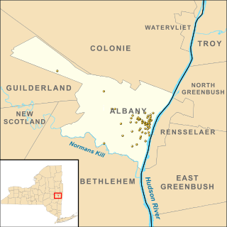
There are 77 properties listed on the National Register of Historic Places in Albany, New York, United States. Six are additionally designated as National Historic Landmarks (NHLs), the most of any city in the state after New York City. Another 14 are historic districts, for which 20 of the listings are also contributing properties. Two properties, both buildings, that had been listed in the past but have since been demolished have been delisted; one building that is also no longer extant remains listed.

The Salem Historic District is located along Main Street and Broadway in Salem, New York, United States. It is a 22-acre (8.9 ha) area containing 79 buildings.

The East Leverett Historic District of Leverett, Massachusetts, encompasses the historic mill village of East Leverett. Centered on the intersection of Cushman Road and Shutesbury Road in the southeastern portion of the rural town, it includes predominantly residential buildings that were built during the height of the area's industrial activity in the first four decades of the 19th century. The architecture is mainly Federal and Greek Revival in style. The district was listed on the National Register of Historic Places in 2014.

The New Ipswich Center Village Historic District encompasses the historic center of the rural town of New Ipswich, New Hampshire. The center village is the town's most densely populated area, with a history dating to the town's founding in 1735. The district extends along Turnpike Road between King and Porter Roads, and southward in a roughly triangular shape, the southern point of which is at the junction of Main Street and Willard Road. The village includes a large number of residences, which were mainly agricultural at first, but also include a number of properties built as summer resort houses in the late 19th and early 20th centuries. It also includes most of the town's historic civic buildings, including its historic town hall, and the Barrett House, now a museum property owned by Historic New England. The district was listed on the National Register of Historic Places in 1991.


