South Thames Estuary and Marshes

Last updated

South Thames Estuary and Marshes
Site of Special Scientific Interest
Second Viewpoint on Black Barn Pools - geograph.org.uk - 1129806.jpg
Location Kent
Grid reference TQ 790 778 [1]
InterestBiological
Area5,289.0 hectares (13,069 acres) [1]
Notification 1991 [1]
Location map Magic Map

South Thames Estuary and Marshes is a 5,289-hectare (13,070-acre) biological Site of Special Scientific Interest which stretches between Gravesend and the mouth of the River Medway in Kent. [1] [2] Part of it is a Nature Conservation Review site, Grade I, [3] and part is a Royal Society for the Protection of Birds nature reserve. [4] It is part of the Thames Estuary and Marshes Ramsar internationally important wetland site [5] and Special Protection Area under the European Union Directive on the Conservation of Wild Birds. [6]

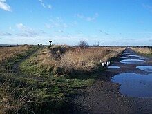
The site consists of a range of habitats including mudflats, saltmarsh, grazing marsh and stretches of shingle. Inland are freshwater lagoons and some patches of deciduous woodland. Over 20,000 migratory waterfowl use this site in the winter, and some species such as greater white-fronted goose, shelduck, gadwall, teal, northern pintail, shoveler, grey plover, curlew and black-tailed godwit are present in internationally important numbers. There are also a number of breeding birds including garganey, avocet, northern pintail, bearded reedling, hen harrier, short-eared owl, ruff, common tern and European golden plover. There are nationally scarce plants on dykes and the drier parts of the site, and the saltmarsh is dominated by salt grasses, the glassworts Salicornia , sea aster, sea lavender and sea purslane. Also present are the nationally scarce plants golden samphire and Puccinellia fasciculata . The diverse invertebrates include nationally rare beetles, flies and true bugs; the scarce emerald damselfly and eight species of water beetle, including the great silver water beetle, are found here. [7]

Related Research Articles

<span class="mw-page-title-main">Halvergate Marshes</span>

The Halvergate Marshes are an area of grazing marsh in the east of the English county of Norfolk. They form part of the area of The Broads and lie between the River Bure and the River Yare, bordering Breydon Water on the east. The marshes cover an area of around 2,642 hectares An area of 1,432.7-hectare (3,540-acre) is a biological Site of Special Scientific Interest. Some areas are also in the Breydon Water Local Nature Reserve, the Broadland and Breydon Water Ramsar sites, The Broads Special Area of Conservation, and The Broads and Breydon Water Special Protection Areas.

<span class="mw-page-title-main">The Swale</span> Channel of the Thames Estuary in Kent, UK

The Swale is a tidal channel of the Thames estuary that separates the Isle of Sheppey from the rest of Kent. On its banks is a 6,509.4-hectare (16,085-acre) biological Site of Special Scientific Interest which stretches from Sittingbourne to Whitstable in Kent. It is also a Ramsar internationally important wetland site and a Special Protection Area under the European Union Directive on the Conservation of Wild Birds. Parts of it are a Nature Conservation Review site, Grade I, National Nature Reserves, a Kent Wildlife Trust nature reserve and a Local Nature Reserve.

<span class="mw-page-title-main">Duddon Estuary</span> Estuary and SSSI in the South Lakeland district of Cumbria, England

The Duddon Estuary is the sandy, gritty estuary of the River Duddon that lies between Morecambe Bay and the North Lonsdale coast.

<span class="mw-page-title-main">Blackwater Estuary</span> Estuary in Essex, England

The Blackwater Estuary is the estuary of the River Blackwater between Maldon and West Mersea in Essex. It is a 5,538 hectare biological Site of Special Scientific Interest (SSSI). An area of 4,395 hectares is also designated a Ramsar Wetland of International Importance, and a Special Protection Area 1,099 hectares is a National Nature Reserve. Tollesbury Wick and part of Abbotts Hall Farm, both nature reserve managed by the Essex Wildlife Trust, are in the SSSI.

<span class="mw-page-title-main">Ribble and Alt Estuaries</span>

The Ribble and Alt Estuaries lie on the Irish Sea coast of the ceremonial counties of Lancashire and Merseyside in the traditional county of Lancashire in north-west England, and form the boundaries of a number of conservation schemes.

<span class="mw-page-title-main">Oare Marshes</span> Local Nature Reserve in Kent, England

Oare Marshes is a 71.4-hectare (176-acre) Local Nature Reserve north of Faversham in Kent. It is owned and managed by Kent Wildlife Trust. It is part of The Swale Nature Conservation Review site, Grade I, National Nature Reserve, Ramsar internationally important wetland site, Special Protection Area under the European Union Directive on the Conservation of Wild Birds, and Site of Special Scientific Interest.

<span class="mw-page-title-main">Colne Estuary</span>

Colne Estuary is a 2915 hectare biological and geological Site of Special Scientific Interest near Brightlingsea in Essex. It is also a Nature Conservation Review site, a National Nature Reserve, a Ramsar wetland site of international importance, a Special Protection Area, a Special Area of Conservation, and a Geological Conservation Review site. Three areas in the site are managed by the Essex Wildlife Trust, Colne Point, Fingringhoe Wick and Howlands Marsh.

<span class="mw-page-title-main">Trimley Marshes</span>

Trimley Marshes is a 77 hectare nature reserve west of Trimley St Mary, on the outskirts of Felixstowe in Suffolk. It is managed by the Suffolk Wildlife Trust. It is in the Suffolk Coast and Heaths Area of Outstanding Natural Beauty, the Orwell Estuary Site of Special Scientific Interest, the Stour and Orwell Estuaries Ramsar site internationally important wetland site and Special Protection Area under the European Union Directive on the Conservation of Wild Birds.

<span class="mw-page-title-main">Alde Mudflats</span>

Alde Mudflats is a 22 hectare nature reserve west of Iken in Suffolk. It is owned by the Crown Estate and managed by the Suffolk Wildlife Trust. It is in the Suffolk Coast and Heaths Area of Outstanding Natural Beauty, and part of the Alde-Ore Estuary Site of Special Scientific Interest, Ramsar internationally important wetland site, Special Area of Conservation, Special Protection Area under the European Union Directive on the Conservation of Wild Birds, and Grade I Nature Conservation Review site,

<span class="mw-page-title-main">Crouch and Roach Estuaries</span>

The Crouch and Roach Estuaries are a 1729 hectare biological Site of Special Scientific Interest (SSSI) at the mouth of the Crouch and Roach rivers in Essex. The Crouch part of the SSSI stretches from near Battlesbridge to Foulness Island, and the Roach from Rochford to the junction with the Crouch. Part of the site is in the Mid-Essex Coast Special Protection Area under the EC Directive on the Conservation of Wild Birds, and a Ramsar wetland site of international importance. It is also part of the Essex Estuaries Special Area of Conservation. An area of 65 hectares is managed by the Essex Wildlife Trust as the Lion Creek and Lower Raypits nature reserve and 8 hectares at Woodham Fen, both of which are managed by the Essex Wildlife Trust. A small area is also a geological SSSI, The Cliff, Burnham-on-Crouch.

<span class="mw-page-title-main">Mucking Flats and Marshes</span>

Mucking Flats and Marshes is a 311.6 biological Site of Special Scientific Interest east of Tilbury in Essex. It is part of the Thames Estuary and Marshes Ramsar site. and Special Protection Area

<span class="mw-page-title-main">Stour Estuary</span> Estuary in England

Stour Estuary is a 2,523 hectare biological and geological Site of Special Scientific Interest which stretches from Manningtree to Harwich in Essex and Suffolk. It is also an internationally important wetland Ramsar site, a Special Protection Area and a Nature Conservation Review site. It is part of the Suffolk Coast and Heaths Area of Outstanding Natural Beauty, and there are Geological Conservation Review sites in Wrabness, Stutton, and Harwich Part of the site is managed by the Royal Society for the Protection of Birds, and a small area is Wrabness Nature Reserve, a Local Nature Reserve managed by the Essex Wildlife Trust.

<span class="mw-page-title-main">Bradwell Shell Bank</span>

Bradwell Shell Bank is a nature reserve on the coast of the Dengie Peninsula near Bradwell-on-Sea in Essex. It is managed by the Essex Wildlife Trust. It is part of the Dengie Site of Special Scientific Interest, Special Protection Area and Ramsar site, and the Essex Estuaries Special Area of Conservation. It is also part of the Blackwater Flats and Marshes, a Grade I site in the Nature Conservation Review.

<span class="mw-page-title-main">Medway Estuary and Marshes</span>

Medway Estuary and Marshes is a 4,748.8-hectare (11,735-acre) biological Site of Special Scientific Interest which stretches along the banks of the River Medway between Gillingham and Sheerness in Kent. It is a Nature Conservation Review site, Grade I, a Ramsar internationally important wetland site, and a Special Protection Area under the European Union Directive on the Conservation of Wild Birds.

<span class="mw-page-title-main">Rye Harbour LNR</span> Nature reserve in East Sussex, England

Rye Harbour LNR is a 325.4-hectare (804-acre) local nature reserve in Rye in East Sussex. The site is part of the 465-hectare (1,150-acre) nature reserve managed by the Sussex Wildlife Trust. It is also part of Dungeness, Romney Marsh and Rye Bay Ramsar site, Special Protection Area and Site of Special Scientific Interest and Dungeness Special Area of Conservation.

<span class="mw-page-title-main">Nutborne Marshes</span>

Nutborne Marshes is a 386.9-hectare (956-acre) Local Nature Reserve east of Thorney Island in West Sussex. It is owned and managed by Chichester Harbour Conservancy. It is part of the Chichester Harbour Site of Special Scientific Interest and Nature Conservation Review site, Grade I*, the Chichester and Langstone Harbours Ramsar site and Special Protection Area, and the Solent Maritime Special Area of Conservation.

<span class="mw-page-title-main">Hurst Castle and Lymington River Estuary</span>

Hurst Castle and Lymington River Estuary is a 1,077.3-hectare (2,662-acre) biological and geological Site of Special Scientific Interest near Lymington in Hampshire. It is a Nature Conservation Review site and two areas are Geological Conservation Review sites. Three areas are local nature reserves, Boldre Foreshore, Sturt Pond and Lymington and Keyhaven Marshes; the latter site is managed by the Hampshire and Isle of Wight Wildlife Trust. Part of it is North Solent National Nature Reserve. It is part of Solent and Southampton Water Ramsar site and Special Protection Area. Parts of it are in Solent Maritime and Solent and Isle of Wight Lagoons Special Areas of Conservation.

<span class="mw-page-title-main">Hythe to Calshot Marshes</span>

Hythe to Calshot Marshes is a 591.8-hectare (1,462-acre) biological Site of Special Scientific Interest which stretches along the west bank of Southampton Water between Calshot and Marchwood in Hampshire. It is part of Solent and Southampton Water Ramsar site and Special Protection Area, and of Solent Maritime Special Area of Conservation. Calshot Marshes is a Local Nature Reserve and Hythe Spartina Marsh is a nature reserve managed by the Hampshire and Isle of Wight Wildlife Trust.

<span class="mw-page-title-main">Lee-on-The Solent to Itchen Estuary</span>

Lee-on-The Solent to Itchen Estuary is a 585.9-hectare (1,448-acre) biological and geological Site of Special Scientific Interest which stretches along the coast between Southampton and Gosport in Hampshire. It is a Geological Conservation Review site. It is part of Solent and Southampton Water Ramsar site and Special Protection Area, and of Solent Maritime Special Area of Conservation. Three areas are Local Nature Reserves, Chessel Bay, Hook with Warsash and Mercury Marshes. One area is Hamble Common Camp, a Scheduled Monument.

<span class="mw-page-title-main">Calshot Marshes</span>

Calshot Marshes is a 51.1-hectare (126-acre) Local Nature Reserve near Calshot, at the junction of The Solent and Southampton Water in Hampshire. It is owned by Hampshire County Council and managed by Hampshire Countryside Service. It is part of Solent and Southampton Water Ramsar site and Special Protection Area, of Solent Maritime Special Area of Conservation and of Hythe to Calshot Marshes Site of Special Scientific Interest.

References

  1. 1 2 3 4 "Designated Sites View: South Thames Estuary and Marshes". Sites of Special Scientific Interest. Natural England. Retrieved 28 February 2018.
  2. "Map of South Thames Estuary and Marshes". Sites of Special Scientific Interest. Natural England. Retrieved 28 February 2018.
  3. Ratcliffe, Derek, ed. (1977). A Nature Conservation Review. Vol. 2. Cambridge, UK: Cambridge University Press. p. 5. ISBN   0521-21403-3.
  4. "Cliffe Pools". Royal Society for the Protection of Birds. Retrieved 22 January 2018.
  5. "Designated Sites View: Thames Estuary and Marshes". Ramsar Site. Natural England. Retrieved 22 January 2018.
  6. "Designated Sites View: Thames Estuary and Marshes". Special Protection Area. Natural England. Retrieved 22 January 2018.
  7. "South Thames Estuary and Marshes citation" (PDF). Sites of Special Scientific Interest. Natural England. Retrieved 28 February 2018.

51°28′16″N0°34′34″E / 51.471°N 0.576°E / 51.471; 0.576