Southton, Texas

Last updated

Southton, Texas
USA Texas location map.svg
Red pog.svg
Southton
Usa edcp location map.svg
Red pog.svg
Southton
Coordinates: 29°17′47″N98°25′7″W / 29.29639°N 98.41861°W / 29.29639; -98.41861
Country United States
State Texas
County Bexar
Elevation
[1]
509 ft (155 m)
Time zone UTC-6 (Central (CST))
  Summer (DST) UTC-5 (CDT)
Area code 210
GNIS feature ID1368846 [1]

Southon is an unincorporated community in Bexar County, in the U.S. state of Texas. [1] According to the Handbook of Texas, the community had a population of 113 in 2000. It is located within the Greater San Antonio metropolitan area.

Contents

History

Southton started as a station on the San Antonio and Aransas Pass Railway in the early 1900s, serving the Yturri-Southton oilfield. A post office was established at Southton in 1910. Southton had a population of 16 in 1910, 90 in 1946, and 113 in 1990 and2000. [2]

Geography

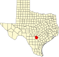
Southton is located off U.S. Highway 281 on the Southern Pacific Railroad, 10 mi (16 km) southeast of Downtown San Antonio in southern Bexar County. [2]

Education

Southton had its own school in 1940. [2] Today, the community is served by the East Central Independent School District.

References

  1. 1 2 3 U.S. Geological Survey Geographic Names Information System: Southton, Texas
  2. 1 2 3 Cameron, Minnie B. "Southton, TX". tshaonline.org. Retrieved August 13, 2022.