Sperry Peak

Last updated
Sperry Peak
Sperry Peak.jpg
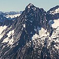
North aspect of Sperry Peak
Highest point
Elevation 6,120 ft (1,865 m) [1]
Prominence 720 ft (219 m) [1]
Parent peak Vesper Peak [2]
Isolation 0.73 mi (1.17 km) [2]
Coordinates 48°00′57″N121°30′09″W / 48.015894°N 121.502633°W / 48.015894; -121.502633 [1]
Geography
USA Washington relief location map.jpg
Red triangle with thick white border.svg
Sperry Peak
Location in Washington
Usa edcp relief location map.png
Red triangle with thick white border.svg
Sperry Peak
Sperry Peak (the United States)
CountryUnited States
State Washington
County Snohomish
Parent range North Cascades
Cascade Range
Topo map USGS Silverton
Geology
Age of rock 260 to 370 million years
Type of rock metamorphosed sandstone shale, conglomerate [3]
Climbing
First ascent 1927
Easiest route Scrambling Southwest slope

Sperry Peak is a 6,120+ ft (1,870+ m) mountain summit in Snohomish County of Washington state.

Contents

Description

Sperry Peak is located 2.5 miles (4.0 km) east of Barlow Pass near the Mountain Loop Highway and the Monte Cristo area, on land managed by the Mount Baker-Snoqualmie National Forest. It is set in the South Fork Stillaguamish River Valley near the western edge of the North Cascades. The nearest higher neighbor is Vesper Peak, 0.74 miles (1.19 km) to the west, with a high connecting ridge between the two. Topographic relief is significant as the summit rises over 3,900 feet (1,189 meters) above the South Fork Stillaguamish in approximately one mile (1.6 km).

History

The peak was named for A. D. (Dick) Sperry, a Silverton mining prospector during the 1890s. [3] The Dick Sperry Picnic Area is near the historic site of the abandoned Sperry-Iverson mine near Silverton. The mountain's toponym has been officially adopted by the United States Board on Geographic Names. [4] The first ascent of the summit was made in 1927 by Norval Grigg and Art Winder. [3]

Climate

Sperry Peak is located in the marine west coast climate zone of western North America. [3] Most weather fronts originating in the Pacific Ocean travel northeast toward the Cascade Mountains. As fronts approach the North Cascades, they are forced upward by the peaks of the Cascade Range (orographic lift), causing them to drop their moisture in the form of rain or snowfall onto the Cascades. As a result, the west side of the North Cascades experiences high precipitation, especially during the winter months in the form of snowfall. [3] Because of maritime influence, snow tends to be wet and heavy, resulting in high avalanche danger. [3] During winter months, weather is usually cloudy, but due to high pressure systems over the Pacific Ocean that intensify during summer months, there is often little or no cloud cover during the summer. [3] Due to its temperate climate and proximity to the Pacific Ocean, areas west of the Cascade Crest very rarely experience temperatures below 0 °F (−18 °C) or above 80 °F (27 °C). [3] The months July through September offer the most favorable weather for viewing or climbing this peak.

Geology

The North Cascades features some of the most rugged topography in the Cascade Range with craggy peaks, ridges, and deep glacial valleys. Geological events occurring many years ago created the diverse topography and drastic elevation changes over the Cascade Range leading to various climate differences.

The history of the formation of the Cascade Mountains dates back millions of years ago to the late Eocene Epoch. [5] With the North American Plate overriding the Pacific Plate, episodes of volcanic igneous activity persisted. [5] In addition, small fragments of the oceanic and continental lithosphere called terranes created the North Cascades about 50 million years ago. [5]

During the Pleistocene period dating back over two million years ago, glaciation advancing and retreating repeatedly scoured the landscape leaving deposits of rock debris. [5] The U-shaped cross section of the river valleys is a result of recent glaciation. Uplift and faulting in combination with glaciation have been the dominant processes which have created the tall peaks and deep valleys of the North Cascades area.

See also

Related Research Articles

<span class="mw-page-title-main">Sahale Mountain</span> Mountain in Washington (state), United States

Sahale Mountain is a jagged, glaciated mountain, in North Cascades National Park, in northern Washington state. The summit of Sahale Mountain is referred to as Sahale Peak. It is 0.3 miles (0.48 km) south of its higher neighbor, Boston Peak, and the saddle between the two is 80 feet (24 m) lower than Sahale's summit. Quien Sabe Glacier is to the west of the ridge between the two peaks while Davenport Glacier is in a cirque east of this ridge and above Horseshoe Basin. Sahale Glacier is south of the summit and east of Sahale Arm, a ridge that extends southwest from Sahale to Cascade Pass. The name Sahale may originate from a Northwest Native American word meaning "high place," "falcon," or "sacred."

<span class="mw-page-title-main">Gunn Peak</span> Mountain in Washington (state), United States

Gunn Peak is a 6,244-foot (1,903-metre) mountain summit in Snohomish County, Washington, United States.

<span class="mw-page-title-main">Mount Larrabee</span> Mountain in Washington (state), United States

Mount Larrabee is a 7,865-foot (2,397-metre) Skagit Range mountain summit situated 1.4 mile south of the Canada–United States border, in the North Cascades of Washington state. It is located immediately southeast of American Border Peak within the Mount Baker Wilderness, which is part of the Mount Baker-Snoqualmie National Forest, and near North Cascades National Park. It is notable for its reddish coloring caused by oxidation of Iron in the rock. The rock consists of reddish interbedded and interfolded phyllites and greenstone. Originally known as Red Mountain, the name was changed in 1951 to honor Charles F. Larrabee (1895–1950), of the prominent Larrabee family of Bellingham, Washington. The toponym was officially adopted in 1951 by the U.S. Board on Geographic Names.

<span class="mw-page-title-main">Stillaguamish Peak</span> Mountain in Washington (state), United States

Stillaguamish Peak is a 5,720+ ft mountain summit near the western edge of the North Cascades, in Snohomish County of Washington state. It is located five miles north-northwest of Barlow Pass near the Monte Cristo area, and is situated on land administered by the Mount Baker-Snoqualmie National Forest. It rises 4,000 feet (1,200 m) above the Stillaguamish River and the Mountain Loop Highway.

<span class="mw-page-title-main">Whistler Mountain (Washington)</span> Mountain in Washington (state), United States

Whistler Mountain is a 7,790-foot (2,370-metre) mountain summit located in Chelan County of Washington state. The mountain is part of the Okanagan Range which is a sub-range of the North Cascades. Whistler Mountain is about two miles west of Washington Pass and one mile east of Rainy Pass. The North Cascades Highway bends around the southern base of the mountain between these two passes. A high ridge connects Whistler to its nearest higher neighbor, Cutthroat Peak, which is 0.78 miles (1.26 km) to the north-northeast. Precipitation runoff from the peak drains into Bridge Creek. Topographic relief is significant as the summit rises over 3,000 feet above the creek and highway in approximately one mile.

<span class="mw-page-title-main">Del Campo Peak</span> Mountain in Washington (state), United States

Del Campo Peak is a prominent summit near the western edge of the North Cascades, in Snohomish County of Washington state. It is located south of Barlow Pass along the Mountain Loop Highway near the Monte Cristo area. It is situated on land administered by the Mount Baker-Snoqualmie National Forest. The mountain is named for a mining claim on the mountain's slope. The nearest peak is Gothic Peak, 0.5 miles (0.80 km) to the southwest, and Foggy Pass is the low point between the two peaks. Foggy Lake lies in Gothic Basin below the south face of Del Campo Peak and collects precipitation runoff which ultimately drains to South Fork Sauk River via Weden Creek. Runoff from the west side of the mountain drains into the Sultan River, and the north side drains into headwaters of the Stillaguamish River. In terms of favorable weather, the best months for climbing are July through September.

<span class="mw-page-title-main">Liberty Mountain (Washington)</span> Mountain in Washington (state), United States

Liberty Mountain is a prominent 5,680-foot-elevation (1,730 m) mountain summit located at the western edge of the North Cascades, in Snohomish County of Washington state. It is located 2.3 miles south of Three Fingers in the Boulder River Wilderness on land administered by the Mount Baker-Snoqualmie National Forest. The mountain's name came from old miners in the Silverton area.

<span class="mw-page-title-main">Big Bear Mountain</span> Mountain in Washington (state), United States

Big Bear Mountain is a 5,641-foot (1,719 m) summit located at the western edge of the North Cascades, in Snohomish County of Washington state. It is located midway between Three Fingers to its north, and Liberty Mountain to its south. Big Bear Mountain is situated in the Boulder River Wilderness on land administered by the Mount Baker-Snoqualmie National Forest. Precipitation runoff from the mountain drains into tributaries of the Sauk and Stillaguamish Rivers.

<span class="mw-page-title-main">Jumbo Mountain</span> Mountain in Washington (state), United States


Jumbo Mountain is a 5,825-foot-elevation (1,775-meter) summit near the western edge of the North Cascades, in Snohomish County of Washington state. It is located four miles south of Darrington, Washington, along the Mountain Loop Highway. It is situated in the Boulder River Wilderness on land administered by the Mount Baker-Snoqualmie National Forest. The mountain was named by miners for its resemblance to an elephant. The nearest higher peak is Buckeye Peak, 3.34 miles (5.38 km) to the west. Precipitation runoff from Jumbo Mountain drains into tributaries of the Stillaguamish River and Sauk River.

<span class="mw-page-title-main">Round Mountain (Washington)</span> Mountain in Washington (state), United States

Round Mountain is a 5,369-foot mountain summit at the western edge of the North Cascades, in Skagit County of Washington state. It is located nine miles northwest of Darrington, Washington, and is situated on land administered by the Mount Baker-Snoqualmie National Forest. Round Mountain is remarkable for its 4,840 feet of prominence which ranks as the most in Skagit County, and eighth-most of all the mountains in Washington state. The nearest higher peak is Whitehorse Mountain, 7.85 miles (12.63 km) to the south-southeast. Precipitation runoff from Round Mountain drains into tributaries of the Stillaguamish River.

<span class="mw-page-title-main">Mount Higgins</span> North American landform of the North Cascades

Mount Higgins is a 5,176-foot-elevation mountain summit located at the western edge of the North Cascades Range, in Skagit County, Washington. Mount Higgins has two subsidiary summits, Skadulgwas Peak which is the fin-shaped middle peak, and also Mount Higgins Lookout Site, the western sub-summit. The mountain is set on land administered by the Mount Baker–Snoqualmie National Forest. Mount Higgins is situated along the north side of State Route 530, mid-way between the communities of Darrington and Oso, near the site of the 2014 Oso mudslide. The nearest higher neighbor is Round Mountain, 0.93 miles (1.50 km) to the north-northeast. This mountain is named for Oso homesteader Walter Higgins. The first ascent was made in 1888 by John Higgins, Frank Lawrence, and Al Baker. Precipitation runoff from Mount Higgins drains into tributaries of the Stillaguamish River. Topographic relief is significant as the south aspect rises 4,800 feet (1,500 m) above the Stillaguamish in two miles.

<span class="mw-page-title-main">Mineral Mountain (North Cascades National Park)</span> Mountain in Washington (state), United States

Mineral Mountain is a 6,800-foot (2,100-metre) mountain summit in the Skagit Range of the North Cascades of Washington state. Mineral Mountain is situated in North Cascades National Park and the summit offers views of Mount Shuksan, Icy Peak, and the Picket Range. Easy Peak is set 2 mi (3.2 km) to the east, and the nearest higher neighbor is Ruth Mountain, 3.06 mi (4.92 km) to the west. Precipitation runoff from Mineral Mountain finds its way north into the Chilliwack River, and south into the Baker River.

<span class="mw-page-title-main">Spider Mountain</span> Mountain in Washington (state), United States

Spider Mountain is an 8,317-foot (2,535-metre) mountain summit located in the Glacier Peak Wilderness in western Chelan County of Washington state. It is part of the North Cascades, which is a subset of the Cascade Range. Meltwater from the Spider Glacier on the steep north face, and other surface runoff from the mountain drains into Flat Creek, which is a tributary of the Stehekin River. Topographic relief is significant as the summit rises 4,200 feet above West Fork Flat Creek in one mile (1.6 km). The nearest higher neighbor is Mount Formidable 1.5 miles (2.4 km) to the west. The Middle Cascade Glacier lies between these two mountains and the Ptarmigan Traverse passes between the two.

<span class="mw-page-title-main">Glory Mountain</span> Mountain in Washington (state), United States

Glory Mountain is a 7,228-foot (2,203-metre) mountain summit located in the North Cascades Range in Chelan County of Washington state. Glory Mountain is situated southeast of Trapper Lake on the shared border of North Cascades National Park and Glacier Peak Wilderness. The nearest higher peak is Trapper Mountain, 1.72 miles (2.77 km) to the west. Precipitation runoff from the mountain drains into Cottonwood Creek and Flat Creek, both tributaries of the Stehekin River. An unofficially named secondary peak called Halleluja Peak 7,120+ ft lies 0.32 miles (0.51 km) to the west of the summit.

<span class="mw-page-title-main">Mount Lago</span> Mountain in Washington (state), United States

Mount Lago is a prominent 8,745-foot (2,665-metre) mountain summit located in the Okanogan Range of the North Cascades, in Okanogan County of Washington state. The mountain is situated on the eastern side of the Cascade crest, in the Pasayten Wilderness, on land managed by the Okanogan–Wenatchee National Forest. The nearest higher peak is Jack Mountain, 19.5 miles (31.4 km) to the west-southwest. Mount Lago is the highest summit of the Okanogan Range, and follows only Jack Mountain {9,075 ft} as the highest peak in the Pasayten Wilderness. Lago is the fourth-most prominent mountain in the Pasayten Wilderness. Precipitation runoff from the mountain drains into tributaries of the Pasayten River and Methow River. The mountain was named for Lage Wernstedt (1878–1959), a Forest Service surveyor who made numerous first ascents of the mountains he was mapping in the North Cascades. Lago, is a play on the way Americans pronounced his name. Lage, pronounced Loggy, had a son named Lago.

<span class="mw-page-title-main">Hall Peak (Washington)</span> Mountain in Washington (state), United States

Hall Peak is a 5,484-foot (1,672-metre) mountain summit located in the South Fork Stillaguamish River Valley near the western edge of the North Cascades, in Snohomish County of Washington state. It is located 5 miles (8.0 km) northwest of Barlow Pass along the Mountain Loop Highway, near the Monte Cristo area, on land administered by the Mount Baker-Snoqualmie National Forest. Its nearest higher peak is Big Four Mountain, one mile to the south-southwest. Both mountains can be prominently seen from the Big Four picnic area, where the trail to the Big Four Ice Caves starts. The peak is named for mining prospector George Hall, who in 1891, discovered the Forty Five claim.

<span class="mw-page-title-main">Wallaby Peak</span> Mountain in Washington (state), United States

Wallaby Peak is a 7,995-foot (2,437-metre) mountain summit located on the boundary line of the Lake Chelan-Sawtooth Wilderness, in Okanogan County, Washington. The mountain is part of the Methow Mountains, which are a subset of the Cascade Range. Wallaby Peak is situated on Kangaroo Ridge which is approximately two miles east and within view of Washington Pass. The nearest higher peak is Big Kangaroo, 0.86 mi (1.38 km) to the north. Precipitation runoff from the peak drains into Early Winters Creek, Cedar Creek, and North Fork Twisp River, all of which are tributaries of the Methow River.

<span class="mw-page-title-main">Pelton Peak</span> Mountain summit

Pelton Peak is a 7,132-foot (2,174-metre) mountain summit located in Chelan County of Washington state. It is part of the North Cascades, a subset of the Cascade Range. Pelton Peak is situated 1.8 miles (2.9 km) southeast of Cascade Pass in North Cascades National Park near the northern end of the Ptarmigan Traverse. The nearest higher peak is Magic Mountain, 0.4 miles (0.64 km) to the southwest. The Yawning Glacier rests on its western flank between these two peaks. Surface runoff from the mountain drains into tributaries of the Stehekin River. The mountain's name comes from the Pelton wheel which was used in early mining times, and several mines were located in the vicinity of Pelton Basin, Horseshoe Basin, and Boston Basin.

<span class="mw-page-title-main">Morning Star Peak</span> Mountain in Washington (state), United States

Morning Star Peak is a 6,020 ft (1,830 m) mountain summit located near the western edge of the North Cascades, in Snohomish County of Washington state. It is situated 2.5 mi (4.0 km) southwest of Barlow Pass along the Mountain Loop Highway near the Monte Cristo area. It is set on land managed by Mount Baker-Snoqualmie National Forest. The nearest higher neighbor is Sperry Peak, 1 mile (1.6 km) to the northwest. Precipitation runoff from the south side of the mountain drains into the Sultan River, and the north side drains into headwaters of the Stillaguamish River. July through September offer the most favorable weather for climbing this mountain.

<span class="mw-page-title-main">Jove Peak</span> Mountain in Washington (state), United States

Jove Peak is a 6,007 ft (1,830 m) mountain summit located 5 mi (8.0 km) north of Stevens Pass on the common border of Snohomish County with Chelan County in Washington state. This peak is situated 12 mi (19 km) west of Lake Wenatchee, in the Henry M. Jackson Wilderness, on land managed by Mount Baker-Snoqualmie National Forest and Okanogan-Wenatchee National Forest. Jove Peak was named by Albert Hale Sylvester for Jove in association with the mythology-theme of nearby Minotaur and Theseus Lakes which are near Labyrinth Mountain, 2.5 mi (4.0 km) to the northeast. Precipitation runoff from the peak drains west into headwaters of Rapid River, or east into Rainy Creek which is a tributary of the Little Wenatchee River.

References

  1. 1 2 3 "Sperry Peak, Washington". Peakbagger.com.
  2. 1 2 "Sperry Peak - 6,140' WA". listsofjohn.com. Retrieved 2023-12-07.
  3. 1 2 3 4 5 6 7 8 Beckey, Fred W. Cascade Alpine Guide, Climbing and High Routes. Seattle, WA: Mountaineers Books, 2008.
  4. "Sperry Peak". Geographic Names Information System . United States Geological Survey, United States Department of the Interior . Retrieved 2019-08-14.
  5. 1 2 3 4 Kruckeberg, Arthur (1991). The Natural History of Puget Sound Country. University of Washington Press.