Spring Creek (Bald Eagle Creek tributary)

Last updated

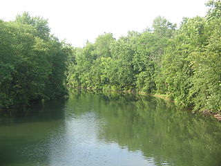
Spring Creek is a 25.2-mile-long (40.6 km) [1] tributary of Bald Eagle Creek in Centre County, Pennsylvania in the United States. [2] [3]

Tributary stream or river that flows into a main stem river or lake

A tributary or affluent is a stream or river that flows into a larger stream or main stem river or a lake. A tributary does not flow directly into a sea or ocean. Tributaries and the main stem river drain the surrounding drainage basin of its surface water and groundwater, leading the water out into an ocean.

Centre County, Pennsylvania county in Pennsylvania, United States

Centre County is a county in the U.S. state of Pennsylvania. As of the 2010 census, the population was 153,990. Its county seat is Bellefonte. Centre County comprises the State College, PA Metropolitan Statistical Area.

Pennsylvania State of the United States of America

Pennsylvania, officially the Commonwealth of Pennsylvania, is a state located in the northeastern and Mid-Atlantic regions of the United States. The Appalachian Mountains run through its middle. The Commonwealth is bordered by Delaware to the southeast, Maryland to the south, West Virginia to the southwest, Ohio to the west, Lake Erie and the Canadian province of Ontario to the northwest, New York to the north, and New Jersey to the east.

Contents

Spring Creek passes through a water gap in Bald Eagle Mountain and joins Bald Eagle Creek at Milesburg.

Water gap opening or notch which flowing water has carved through a mountain range

A water gap is a gap that flowing water has carved through a mountain range or mountain ridge and that still carries water today. Such gaps that no longer carry water currents are called wind gaps. Water gaps and wind gaps often offer a practical route for road and rail transport to cross the mountain barrier.

Bald Eagle Mountain mountain in central Pennsylvania, USA

Bald Eagle Mountain – once known locally as Muncy Mountain – is a stratigraphic ridge in the Ridge-and-Valley Appalachians of central Pennsylvania, USA, running east of the Allegheny Front and northwest of Mount Nittany. It lies along the southeast side of Bald Eagle Creek, and south of the West Branch Susquehanna River, and is the westernmost ridge in its section of the Ridge-and-valley Appalachians. The ridge line separates the West Branch Susquehanna Valley from the Nippenose and White Deer Hole Valleys, and Bald Eagle Valley from Nittany Valley.

Milesburg, Pennsylvania Borough in Pennsylvania, United States

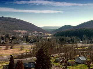
Milesburg is a borough in Centre County, Pennsylvania. It is part of the State College, Pennsylvania Metropolitan Statistical Area. The population was 1,123 at the 2010 census.

The stream is the site of a kayak and canoe slalom training center, located along Sunnyside Boulevard in Bellefonte. Removal of the McCoy & Linn dam in 2007 now permits a Class I whitewater run of about 3 miles (at higher water levels) from Bellefonte to Milesburg.

Bellefonte, Pennsylvania Borough in Pennsylvania, United States

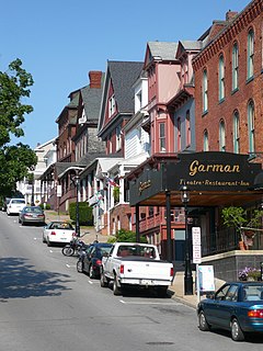
Bellefonte is a borough and the county seat of Centre County in the U.S. state of Pennsylvania. It is about twelve miles northeast of State College and is part of the State College, Pennsylvania Metropolitan Statistical Area. The borough population was 6,187 at the 2010 Census. It houses the Centre County Courthouse located downtown on the square. Bellefonte has also been home to five of Pennsylvania's governors as well as two other governors. All seven are commemorated in a monument located at Talleyrand Park.

Tributaries

See also

Related Research Articles

Little Juniata River tributary of the Juniata River in Pennsylvania, United States

The Little Juniata River, sometimes called the "Little J," is a river that is not owned by anyone person. It is held in trust by the state of Pennsylvania for the people of the state and beyond. Pennsylvania. 32.1-mile-long (51.7 km) tributary of the Juniata River in the Susquehanna River watershed. It is formed at Altoona by the confluence of several short streams. It flows northeast in the Logan Valley at the foot of Brush Mountain.

Pine Creek is an 18.4-mile-long (29.6 km) tributary of Penns Creek in central Pennsylvania in the United States. Via Penns Creek, it is part of the Susquehanna River watershed.

Beech Creek (Pennsylvania) creek in Pennsylvania, United States

Beech Creek is a 27.3-mile-long (43.9 km) tributary of Bald Eagle Creek in Centre and Clinton counties, in Pennsylvania in the United States.

Bermudian Creek is a 24.9-mile-long (40.1 km) tributary of Conewago Creek in Adams and York counties in Pennsylvania in the United States.

Big Spring Creek is a 5.0-mile-long (8.0 km) tributary of Conodoguinet Creek in Cumberland County, Pennsylvania in the United States.

Slab Cabin Run is an 11.2-mile-long (18.0 km) tributary of Spring Creek in Centre County, Pennsylvania in the United States.

Nittany and Bald Eagle Railroad

The Nittany and Bald Eagle Railroad is a short line railroad that operates 70 miles (110 km) of track in Blair, Centre, and Clinton counties in Pennsylvania in the United States. It is part of the North Shore Railroad System.

Frankstown Branch Juniata River river in the United States of America

The Frankstown Branch Juniata River is a 46.0-mile-long (74.0 km) tributary of the Juniata River in Blair and Huntingdon Counties, Pennsylvania, in the United States.

Raystown Branch Juniata River river in the United States of America

The Raystown Branch Juniata River is the largest and longest tributary of the Juniata River in south-central Pennsylvania in the United States.

Fishing Creek (Bald Eagle Creek tributary) tributary of the Bald Eagle Creek in Pennsylvania

Fishing Creek is a 42.8-mile-long (68.9 km) tributary of Bald Eagle Creek in Clinton County, Pennsylvania in the United States.

Sinking Creek is a tributary of Penns Creek in Centre County, Pennsylvania, in the United States. It is approximately 19.8 miles (31.9 km) long and flows through Harris Township, Potter Township, and Gregg Township. The watershed of the creek has an area of 40.70 square miles (105.4 km2).

Bald Eagle Valley

The Bald Eagle Valley of central Pennsylvania, United States is the low-lying area draining into the Bald Eagle Creek between the Allegheny Front and the Bald Eagle Mountain ridge, south of the West Branch Susquehanna River, in the Ridge-and-valley Appalachians. It is southwest of the West Branch Susquehanna Valley that includes Williamsport and Northwest of the Nittany Valley that includes State College.

Nittany Valley Region in Pennsylvania, United States

The Nittany Valley is an eroded anticlinal valley in the central portion of Centre County, Pennsylvania in the United States. It is separated from the Bald Eagle Valley by Bald Eagle Mountain and from Penns Valley by Mount Nittany. The valley is closed to the north by a high plateau that joins these two mountain ridges, but is open to the south at the southern terminus of Mount Nittany. The valley drains to the Bald Eagle Creek through water gaps in Bald Eagle Mountain formed by Spring Creek, and Fishing Creek, along with smaller streams running through Curtain Gap and Howard Gap. The Northwest side of the valley between the Bald Eagle Mountain ridge and the lower Sand Ridge is also known as the "Little Nittany Valley".

Bellefonte and Snowshoe Railroad

The Bellefonte and Snowshoe Railroad was a coal-hauling railroad in Centre County, Pennsylvania. Begun in 1859, it came under the control of the Pennsylvania Railroad in 1881. Closing of mines in the 1930s resulted in the decline of traffic on the railroad, which was abandoned in 1959.

Bald Eagle Creek (West Branch Susquehanna River tributary) tributary of the West Branch Susquehanna River in Pennsylvania, United States

Bald Eagle Creek is a 55.2-mile-long (88.8 km) tributary of the West Branch Susquehanna River mostly in Centre County, Pennsylvania, in the United States.

Honey Creek is a 20.3-mile-long (32.7 km) tributary of Kishacoquillas Creek in Mifflin County, Pennsylvania in the United States.

Bald Eagle and Spring Creek Navigation

The Bald Eagle and Spring Creek Navigation Company was a canal company in central Pennsylvania intended to link the iron industry of Bellefonte, Pennsylvania, with the Pennsylvania canal system. Opened for half its length in 1837, the remainder of the canal was not completed until 1848. Destroyed by flooding in 1865, it was not rebuilt; a paralleling railroad completed that year replaced it.

Kishacoquillas Creek is a 24.0-mile-long (38.6 km) tributary of the Juniata River in Mifflin County, Pennsylvania in the United States.

Mountain Creek (Yellow Breeches Creek tributary) river in the United States of America

Mountain Creek is a 20.9-mile-long (33.6 km) tributary of Yellow Breeches Creek in Cumberland County, Pennsylvania.

Wallace Run is a tributary of Bald Eagle Creek in Centre County, Pennsylvania, in the United States. It is 12.1 miles (19.5 km) long and is a low-alkalinity stream. The stream flows through Union Township and Boggs Township in Centre County. Most of the watershed is in Boggs Township. North Branch Wallace Run is one tributary of the stream. The watershed has an area of 24 square miles. Oaks, maples, ash trees, birches, hemlocks, and rhododendrons all exist in the upper reaches of the stream, which is mostly forested. The lower reaches of the stream are mostly developed.

References

  1. U.S. Geological Survey. National Hydrography Dataset high-resolution flowline data. The National Map, accessed August 8, 2011
  2. U.S. Geological Survey Geographic Names Information System: Spring Creek (Bald Eagle Creek tributary)
  3. Gertler, Edward. Keystone Canoeing, Seneca Press, 2004. ISBN   0-9749692-0-6

Coordinates: 40°56′35″N77°47′14″W / 40.94306°N 77.78722°W / 40.94306; -77.78722

Geographic coordinate system Coordinate system

A geographic coordinate system is a coordinate system that enables every location on Earth to be specified by a set of numbers, letters or symbols. The coordinates are often chosen such that one of the numbers represents a vertical position and two or three of the numbers represent a horizontal position; alternatively, a geographic position may be expressed in a combined three-dimensional Cartesian vector. A common choice of coordinates is latitude, longitude and elevation. To specify a location on a plane requires a map projection.