
Victorian architecture is a series of architectural revival styles in the mid-to-late 19th century. Victorian refers to the reign of Queen Victoria (1837–1901), called the Victorian era, during which period the styles known as Victorian were used in construction. However, many elements of what is typically termed "Victorian" architecture did not become popular until later in Victoria's reign, roughly from 1850 and later. The styles often included interpretations and eclectic revivals of historic styles (see Historicism). The name represents the British and French custom of naming architectural styles for a reigning monarch. Within this naming and classification scheme, it followed Georgian architecture and later Regency architecture and was succeeded by Edwardian architecture.

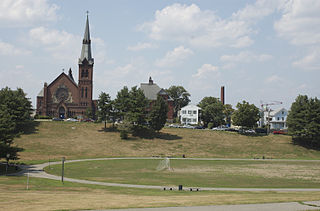
Spring Hill is the name of a ridge in the central part of the city of Somerville, Massachusetts, United States, and the residential neighborhood that sits atop it. It runs northwest to southeast, roughly bounded by Highland Avenue, Somerville Avenue, Elm Street, and Willow Avenue. Summer Street runs along the hill's crest.
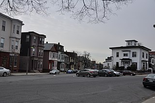
The Old Dauphin Way Historic District is a historic district in the city of Mobile, Alabama, United States. It was named for Dauphin Way, now known as Dauphin Street, which bisects the center of the district from east to west. The district is roughly bounded by Broad Street on the east, Springhill Avenue on the north, Government Street on the south, and Houston Avenue on the west. Covering 766 acres (3.10 km2) and containing 1466 contributing buildings, Old Dauphin Way is the largest historic district in Mobile.

The Newtonville Historic District is a historic district in the village of Newtonville, in Newton, Massachusetts. The district encompasses the southern portion of the village's business district, as well as surrounding residential areas. It was listed on the National Register of Historic Places in 1986, and enlarged in 1990.
The Eagle Hill Historic District is a residential historic district roughly bounded by Meridian, Princeton, and White Streets meeting in Prescott Square in the East Boston neighborhood of Boston, Massachusetts, United States. This part of East Boston was developed roughly between 1834 and 1900, and includes a remarkable concentration of original housing stock. The neighborhood is dense, with a mix of single-family and multiple-family wood frame housing. The preponderance of these buildings are Italianate, Second Empire or Renaissance Revival in style, with earlier Greek Revival and later Colonial Revival and Queen Anne styling present in smaller numbers. Some of the most prominent properties in the district are: the Donald McKay House, Trinity Neighborhood House, the Paul Curtis Mansion, and the William Waters Jr. House. Another noteworthy property in the district is the East Boston High School located at the top of the hill, built on a site formerly used as a reservoir.

Clam Point is a sub-neighborhood in Boston, Massachusetts, USA, noteworthy for its collection of substantial Italianate Mansard residences. The area is known to have the most cohesive, intact collection of mansion-scale mid 19th-century housing in Boston, and includes the Park, Everett, Freeport, Mill, Ashland, Blanche Streets, and Victory Road in the Dorchester neighborhood of Boston. In the past decade, the historic area has attracted a new wave of development due to its location on a prime strip of waterfront overlooking Dorchester Bay and its proximity to the Red Line.

The Sumner Hill Historic District encompasses a predominantly residential area of high-quality late 19th-century residences in the Jamaica Plain neighborhood of Boston, Massachusetts. It is roughly bounded by Seaverns Avenue, Everett Street, Carolina Avenue, and Newbern Street just east of the neighborhoods commercial Centre Street area. The district features Second Empire, Italianate, and Queen Anne style architecture, and was listed on the National Register of Historic Places in 1987.
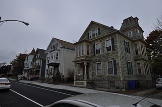
The North Bedford Historic District is a historic district roughly bounded by Summer, Parker, Pleasant and Kempton Streets in New Bedford, Massachusetts. It encompasses a predominantly residential neighborhood north of downtown New Bedford which was developed primarily in the mid 19th-century. It features a variety of worker housing of the period, as well as a number of higher quality houses built by businessmen. The district was added to the National Register of Historic Places in 1979.

The Cotuit Historic District is a historic district encompassing the heart of the village of Cotuit in Barnstable, Massachusetts. It extends along Main Street from Lowell Street in the north to Sea Street in the south, and includes portions of Ocean View Avenue and properties on adjacent roads. The oldest properties date to the late 18th century, but saw its greatest development during the height of the area's maritime industry in the mid 19th century. In the late 19th and early 20th century the area saw new development as a summer resort area. The district was listed on the National Register of Historic Places in 1987.

The Peabody Civic Center Historic District encompasses a well-preserved portion of the historic center of Peabody, Massachusetts. Extending along Chestnut and Franklin Streets south of Peabody City Hall, the district includes a small residential area built in the mid-19th century, as well as the city hall and St. JOhn the Baptist Roman Catholic Church, two monumental structures defining the town's civic heart. The district was added to the National Register of Historic Places in 1980.

The Martin W. Carr School is a historic school building located at 25 Atherton Street, in the Spring Hill area of Somerville, Massachusetts. Built in 1898, it is a prominent local example of Colonial and Renaissance Revival architecture, and the only known surviving work of local architect Aaron H. Gould. It served the local neighborhood as a school until 1980, and was subsequently converted into condominiums. It was listed on the National Register of Historic Places in 1984.

The Walnut Street School is a historic school building at 55 Hopkins Street in Reading, Massachusetts. A two-room schoolhouse built in 1854, it is the town's oldest public building. Since 1962 it has been home to the Quannapowitt Players, a local theatrical company. The building was listed on the National Register of Historic Places in 1984.
The Andover Street Historic District is a linear residential historic district in the Belvidere neighborhood of eastern Lowell, Massachusetts. The district encompasses large, fashionable houses and estates that were built between the 1860s and the 1930s. It includes properties at 245—834 Andover Street, and at 569 and 579 East Merrimack Street. The district was listed on the National Register of Historic Places in 2000.
The Belvidere Hill Historic District encompasses a residential area on the east side of Lowell, Massachusetts known for its fine 19th-century houses. The area, roughly bounded by Wyman, Belmont, Fairview, and Nesmith Streets, was developed beginning in the 1850s, and was one of the finest neighborhoods in the city, home to many of its business and civic leaders. It was listed on the National Register of Historic Places in 1995.
The South Common Historic District of Lowell, Massachusetts, encompasses the city's South Common and the various public, religious, and private residential buildings that flank its borders. The South Common, about 22.5 acres (9.1 ha) in size, was purchased by the city in 1845 in an auction by the Proprietors of Locks and Canals, who owned much of the city's industrial area. Although the common was landscaped, it was not apparently done so to a plan. It quickly became lined with fashionable residences, and several iconic public buildings, including the 1850 courthouse, a Romantic Revival structure designed by Ammi Young, and a series of Gothic Revival churches. Highland Avenue was built out with a series of fine Italianate houses.
The Washington Square Historic District of Lowell, Massachusetts encompasses a historic subdivision laid out in 1832. The focal point of the subdivision is Kittridge Park, which lies on the eastern side of the district and was an original part of the subdivision plan developed by the Nesmith Brothers. It was the first significant residential subdivision in the city aimed at a wealthier clientele, and was designed by landscape architect Alexander Wadsworth. The district was added to the National Register of Historic Places in 1982, and expanded slightly in 1999.

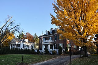
The Lasell Neighborhood Historic District is a historic district roughly bounded by Woodland, Studio Roads, Aspen, Seminary Avenue, and Grove Street in Newton, Massachusetts - a village of Auburndale, Massachusetts. The area includes high-quality late - 19th and early - 20th century housing built in the area and includes buildings on the campus of Lasell University, established as the Auburndale Female Seminary in 1851. The district was listed on the National Register of Historic Places in 1986.

The Washington Street Historic District is north of Valparaiso's downtown. The neighborhood has tree-lined streets with many examples of late nineteenth- and early twentieth-century houses and public buildings. Valparaiso began to expand after the railroads came through the township in the 1860s; Pittsburgh, Fort Wayne and Chicago Railroad, the New York, Chicago and St. Louis Railroad and the Grand Trunk Railroad. Residential neighborhoods grew up between the business district and the railroads. On Valparaiso's south side industrial and transportation area expanded, thus residential development was north of downtown.

The Trufant Historic District encompasses a concentration of 19th-century middle-class residential housing on the south side of Bath, Maine. This area was most heavily developed during Bath's heyday as a major shipbuilding center, and includes numerous examples of Greek Revival and Italianate styling. It was listed on the National Register of Historic Places in 2004.

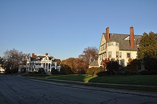
The South Willard Street Historic District encompasses what was once the most fashionable residential area of Burlington, Vermont. Located along South Willard Street between Pearl and Beech Streets, the architecturally heterogeneous area was in the 19th century home to major estates of the city's business leaders, and has since been infilled with a variety of late 19th and early 20th century architecture. The district was listed on the National Register of Historic Places in 1988.


