St Raphael's Estate

Last updated

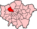
St Raphael's Estate is a housing estate in Neasden and part of the London Borough of Brent in Northwest London, England. [1] A community centre is located within the estate on Rainborough Close. [2] It forms part of the NW10 postcode.

Contents

The low-density estate was built between 1967 and 1982, although some of the land dates back further as Brentfield Estate. It has about 1,174 properties of which the vast majority are owned by the local Brent authority. The estate has a relatively high rate of child poverty, and its geographic location makes it somewhat isolated from Wembley or other retail town centres. [3] To its east, St Raphael's Estate is cut by the A406 North Circular Road dual carriageway, while to its west the River Brent and a recreational ground separates it from the Tokyngton locality of Wembley. The superstores of Brent Park are directly to its north.

It is proposed as of 2010 that 21 new homes will be built on the estate. [1] [ needs update ]

The majority of the inhabitants are of Afro-Caribbean heritage.[ citation needed ]

Transport

Two London bus routes terminate at Pifield Way: the 224 and the 232. The 92 terminates at Drury Way ("St Raphael's North"). Because St Raphael's is very close to Brent Park, there are links to many other bus routes, at IKEA and Tesco, and along the North Circular Road.

Stonebridge Park station and Neasden tube station are the nearest train stations.

Notable residents

Notable sites and organisations

See also

Related Research Articles

<span class="mw-page-title-main">Kingsbury, London</span> Human settlement in England

Kingsbury is a district of northwest London in the London Borough of Brent. Its ancient scope stretches to include various distinct areas that were once small villages until the inter-war period. Kingsbury was in 2001 a ward and in 2011 was identifiable with the Fryent and Barnhill wards approximately. Today it forms a quiet suburb between Fryent Country Park to the west and the Brent Reservoir to the east, along with a Jubilee line tube station and accompanying shopping district on the western side. The postal district is NW9 which it shares with Colindale and West Hendon.

<span class="mw-page-title-main">Neasden</span> Human settlement in England

Neasden is a suburban area in northwest London, England. It is located around the centre of the London Borough of Brent and is within the NW2 (Cricklewood) and NW10 (Willesden) postal districts. Neasden is near Wembley Stadium, the Welsh Harp, and Gladstone Park; the reservoir and River Brent marks its boundaries with Kingsbury and Wembley, while Gladstone Park and the Dudding Hill line separates it from Dollis Hill and Church End respectively. The A406 North Circular Road runs through the middle of Neasden; to the west is the Neasden Underground Depot, Brent Park retail area and the St Raphael's Estate; on the east is Neasden tube station, the large Neasden Temple, and former Neasden Power Station. The area is known as the place where Bob Marley lived after moving from Jamaica, living at a house in The Circle; the house was honoured with a blue plaque in 2012.

<span class="mw-page-title-main">London Borough of Brent</span> Local government district in London

Brent is a borough in north-west London, England. It is known for landmarks such as Wembley Stadium, the Swaminarayan Temple and the Kiln Theatre. It also contains the Welsh Harp reservoir and the Park Royal commercial estate. The local authority is Brent London Borough Council.

<span class="mw-page-title-main">Wembley</span> Suburb of London

Wembley is a large suburb in the London Borough of Brent, north-west London, 8 miles (13 km) northwest of Charing Cross. It includes the neighbourhoods of Alperton, Kenton, North Wembley, Preston, Sudbury, Tokyngton and Wembley Park. The population was 102,856 in 2011.

<span class="mw-page-title-main">North Circular Road</span> Ring road around Central London

The North Circular Road is a 25.7-mile-long (41.4 km) ring road around Central London in England. It runs from Chiswick in the west to Woolwich in the east via suburban North London, connecting various suburbs and other trunk roads in the region. Together with its counterpart, the South Circular Road, it mostly forms a ring road around central London, except for crossing of the River Thames, which is done by the Woolwich Ferry.

<span class="mw-page-title-main">Neasden tube station</span> London Underground station

Neasden is a London Underground station in Neasden. It is on the Jubilee line, between Wembley Park and Dollis Hill stations. Metropolitan line trains pass through the station but do not stop. The Chiltern Main Line/London to Aylesbury Line runs to the west of the station.

<span class="mw-page-title-main">Brent South (UK Parliament constituency)</span> Parliamentary constituency in the United Kingdom, 1974–2010

Brent South was a constituency for the House of Commons of the UK Parliament; the areas of the constituency chiefly fell into the new Brent Central for the 2010 general election which was the date of its abolition. It elected one member (MP) by the first past the post system of election.

<span class="mw-page-title-main">Sufra (charity)</span> Organization based in the United Kingdom

Sufra is a community food and support hub based in Stonebridge ward in the London Borough of Brent.

<span class="mw-page-title-main">Brent Reservoir</span>

The Brent Reservoir is a reservoir in North West London. It straddles the boundary between the boroughs of Brent and Barnet and is owned by the Canal & River Trust. The reservoir takes its informal name from a public house called The Welsh Harp, which stood nearby until the early 1970s. It is a 68.6-hectare (170-acre) biological Site of Special Scientific Interest (SSSI), the only SSSI in either borough and among more than 30 SSSIs in Greater London.

<span class="mw-page-title-main">Brent Central (UK Parliament constituency)</span> Parliamentary constituency in the United Kingdom, 2010–2024

Brent Central was a constituency in Greater London, represented in the House of Commons of the UK Parliament from 2010 until its abolition for the 2024 general election by Dawn Butler of the Labour Party.

<span class="mw-page-title-main">London Buses route 18</span> London bus route

London Buses route 18 is a Transport for London contracted bus route in London, England. Running between Sudbury & Harrow Road station and Euston bus station, it is operated by RATP Dev Transit London.

<span class="mw-page-title-main">Stonebridge, London</span> Human settlement in England

Stonebridge is a locality in the London Borough of Brent. Stonebridge is situated in southern Brent and makes up the western part of Harlesden. The A404 runs through the district known locally as Brentfield and Hillside, while to the south are railway tracks and to the west is the North Circular Road along with Stonebridge Park station. The area is known for the previously troubled 1960s Stonebridge housing estate, which was completely redeveloped in the 2010s.

<span class="mw-page-title-main">Dudding Hill line</span> Railway line in northwest London

The Dudding Hill Line is a railway line in west and north-west London running from Acton to Cricklewood. It is roughly 4 miles (6.4 km) long, with a 30 miles per hour (48 km/h) speed limit, and semaphore signalling. The line has no scheduled passenger service, no stations, and is not electrified. It is lightly used by freight trains and, very occasionally, passenger charter trains.

<span class="mw-page-title-main">Tokyngton</span> Archaic name for part of Wembley, London

Tokyngton, also locally known as Monks Park, is a locality that forms the southeastern part of the town of Wembley in Greater London, in the London Borough of Brent, England. Most refer it as being either Wembley or Stonebridge, as the name Tokyngton is historical and out of favour, hardly used by locals and not noted as a destination on road signs, except for street names and public places bearing the name. Tokyngton was first mentioned in 1171, its name meaning "the farm of the sons of Toca". However the name does officially survive as an electoral ward of Brent London Borough Council.

Fryent Country Park, together with Barn Hill Open Space, is a large park situated in the north of the London Borough of Brent. It covers 103 hectares of rolling fields and small woods.

The North and West London Light Railway (NWLLR), formerly known as the Brent Cross Railway, is a proposal for a light rail system in North and West London in the UK. It was put forward by the London group of the Campaign for Better Transport and by the Coalition for a Sustainable Brent Cross Cricklewood.

<span class="mw-page-title-main">Gladstone Park, London</span> Park in the Dollis Hill area of London

Gladstone Park is situated in the Dollis Hill area of north-west London. It is about 35 hectares in area.

Church End, known locally as "Church Road", is a small locality in the London Borough of Brent, north of Harlesden, west of Willesden and south of Neasden. Its population is predominantly Afro-Caribbean.

<span class="mw-page-title-main">Chalkhill Estate</span> Public housing project in London UK

Chalkhill Estate is located in the Wembley Park area of north-west London. It was originally one of three large council estates built in the London Borough of Brent by the early 1970s, along with Stonebridge and South Kilburn. The design was based on that of Park Hill in Sheffield. The high-rise estate was demolished by 2000 and gradually replaced by new low-rise builds.

<span class="mw-page-title-main">St. Raphael's Edible Garden</span> Community garden in London

St. Raphael's Edible Garden is a community garden located in St. Raphael's, Neasden. The former derelict site was acquired by Sufra in 2016 and was granted permission to build a community garden project by the Brent Council in 2017. The garden is a private space for local residence and visitors as a space to learn and engage in community gardening activities.

References

  1. 1 2 "New homes at St Raphael's". 17 June 2010. Retrieved 8 July 2010.
  2. "St Raphael's Community Centre". Brent Brain. Retrieved 8 July 2010.
  3. "WEMBLEY MATTERS: Big changes for St Raphael's Estate on Brent Cabinet agenda". 3 November 2018.

51°33′N0°16′W / 51.55°N 0.26°W / 51.55; -0.26