Appleby-in-Westmorland is a market town and civil parish in the Eden District of Cumbria, England, with a population of 3,048 at the 2011 Census. Crossed by the River Eden, Appleby was the county town of the historic county of Westmorland. It was known just as Appleby until 1974/1976, when the council of the successor parish to the borough changed it to retain the name Westmorland, which was abolished as an administrative area under the Local Government Act 1972. It lies 14 miles (23 km) south-east of Penrith, 32 miles (51 km) south-east of Carlisle, 27 miles (43 km) north-east of Kendal and 45 miles (72 km) west of Darlington.
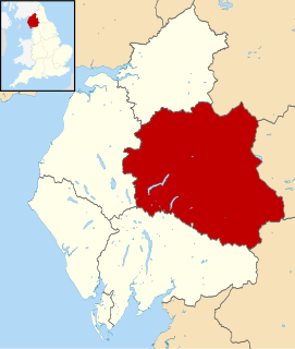
Eden is a local government district in Cumbria, England, based at Penrith Town Hall in Penrith. It is named after the River Eden, which flows north through the district toward Carlisle. Its population of 49,777 at the 2001 census, increased to 52,564 at the 2011 Census. A 2019 estimate was 53,253. In July 2021 it was announced that in April 2023, Cumbria will divide into two unitary authorities. Eden District Council will cease and its functions pass to a new authority, Westmorland and Furness Council, covering the current districts of Barrow-in-Furness, Eden and South Lakeland.

Penrith is a market town and civil parish in the county of Cumbria, England, less than 3 miles (5 km) outside the Lake District National Park. It had a population of 15,181 at the 2011 Census. Historically in Cumberland, Penrith's local authority is currently Eden District Council, which is based in the town, as were the defunct Penrith Urban and Rural District councils. From 1974 to 2015, it was an unparished area with no local council, but a civil parish was reintroduced as Penrith Town Council and first elected on 7 May 2015.

Kirkby Stephen is a market town and civil parish in Cumbria, North West England. Historically part of Westmorland, it lies on the A685, surrounded by sparsely populated hill country, about 25 miles (40 km) from the nearest larger towns: Kendal and Penrith. The River Eden rises 6 miles (9.7 km) away in the peat bogs below Hugh Seat and passes the eastern edge of the town. At the 2001 census the parish had a population of 1,832, increasing to 1,822 at the 2011 Census. The settlement had a 2011 population of 1,522.
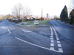
Orton is a village and civil parish in Cumbria, England. It lies 15 miles (24 km) south of Penrith, 8 miles (13 km) from Appleby-in-Westmorland and 1.5 miles (2.4 km) from the M6 motorway. The village is in the upper Lune Valley, at the foot of Orton Scar in the Orton Fells. The Lake District is nearby. The parish includes a wide area outside the village, and had a population of 594 in 2001, decreasing to 588 at the 2011 Census.

Shap is a linear village and civil parish located among fells and isolated dales in Eden district, Cumbria, England, in the historic county of Westmorland. The parish had a population of 1,221 in 2001, increasing slightly to 1,264 at the 2011 Census.

Patterdale is a small village and civil parish in the eastern part of the English Lake District in the Eden District of Cumbria, in the traditional county of Westmorland, and the long valley in which they are found, also called the Ullswater Valley. The parish had a population of 460 in 2001, increasing to 501 at the 2011 Census.

Brougham is a small village and civil parish on the outskirts of Penrith in the Eden District of Cumbria, England. According to the 2001 census the parish had a population of 279, falling marginally to 277 at the 2011 Census.
Kirkoswald is a village, civil parish, and former market town located in the Lower Eden Valley of Cumbria, England, formerly in Cumberland, about 9 miles (14 km) from Penrith. The village, referred to colloquially as KO, had a population of 870 at the 2001 census, which rose to 901 at the 2011 Census.

Hesket is a large civil parish in the Eden District of Cumbria, England, on the main A6 between Carlisle and Penrith. At the 2001 census it had a population of 2,363, increasing to 2,588 at the 2011 census, and estimated at 2,774 in 2019. The parish formed in 1894 with the passing of the Local Government Act 1894 and grew to embrace the parish of Plumpton Wall by a County Review Order in 1934. Hesket is part of the historic royal hunting ground of Inglewood Forest. Settlement hereabouts dates back to the Roman occupation.
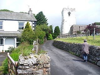
Dacre is a small village, civil parish and electoral ward in the Lake District National Park in the Eden District of Cumbria, England, and historically in Cumberland. In the 2001 census, the parish, which includes Newbiggin and Stainton, had a population of 1,326, increasing to 1,438 at the 2011 Census.

Plumpton or Plumpton Wall is a small village and former civil parish about 4 miles (6 km) north of Penrith, in the Eden district, in the county of Cumbria, England. In 1931 the parish had a population of 320.
Lazonby is a village and civil parish in the Lower Eden Valley of Cumbria; it is located about 8 miles (13 km) north north-east of Penrith and 24 miles (38 km) south of the Scottish Borders. The total population of the ward of Lazonby, which also includes the nearby villages of North Dykes, Great Salkeld and Salkeld Dykes, was 1,425 at the time of the 2001 UK Census; this figure included 1,011 people between the ages of 16 and 74, of whom 675 were in employment. At the time of the 2011 Census, the population had reduced to 976.

Langwathby is a village and civil parish in northern Cumbria, England, about 5 miles (8 km) north east of Penrith on the A686 road. The village lies on the east bank of the River Eden. At the 2001 census the parish had a population of 748, increasing to 866 at the 2011 Census.

Great Salkeld is a small village and civil parish in the Eden District of Cumbria, England, a few miles to the north east of Penrith and bordering the River Eden. At the 2001 census the parish had a population of 445, decreasing to 412 at the 2011 Census.

Newbiggin is a small village in Cumbria, North West England. It is in the Dacre civil parish about 3 mi (4.8 km) west of Penrith. It lies at 750 ft (230 m) sheltered from the prevailing south-westerly wind by Flusco Pike, 150 ft (46 m) higher. It is described as a "non-nucleated village," lying for a mile along either side of the C3019 between the A66 and the B5288. There are at least six other villages in Cumbria with the same name, which is derived from the Old English ‘new biggin', or new house. Locally this village is referred to as the "Stainton Newbiggin," to distinguish it from the others.

Soulby is a hamlet in the civil parish of Dacre, near the villages of Dacre and Pooley Bridge and the A592 road, in the Eden district, in the English county of Cumbria. In the Imperial Gazetteer of England and Wales of 1870-72 it had a population of 66. The name "Soulby" means "village near the fork or joining of two rivers".

Grinsdale is a village and former civil parish, now in the civil parish of Beaumont, in the Carlisle district, in the English county of Cumbria. Grinsdale has a church called St Kentigern's Church. It is the source of the surname. It is also beside the River Eden. The civil parish was merged into Beaumont in 1934. In 1931 the civil parish had a population of 161.

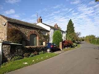
Thrimby is a hamlet and former civil parish, now in the parish of Little Strickland, in the Eden district of Cumbria, England. In 2001 the population of the civil parish of Thrimby was 30. The population measured at the 2011 Census was less than 100. Details are included in the parish of Great Strickland. It has a Grade 2* farmhouse called Thrimby Hall, as seen in series 4 of the BBC Two fly-on-the-wall farming documentary "This Farming Life".