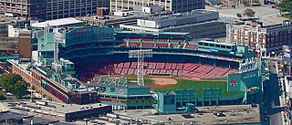
Fenway–Kenmore is an officially recognized neighborhood of Boston, Massachusetts, United States. While it is considered one neighborhood for administrative purposes, it is composed of numerous distinct sections that, in casual conversation, are almost always referred to as "Fenway", "the Fenway", "Kenmore Square", or "Kenmore". Furthermore, the Fenway neighborhood is divided into two sub-neighborhoods commonly referred to as East Fenway/Symphony and West Fenway.

Chestnut Hill is a wealthy New England village located six miles (10 km) west of downtown Boston, Massachusetts, United States. It is best known for being home to Boston College and a section of the Boston Marathon route. Like all Massachusetts villages, Chestnut Hill is not an incorporated municipal entity. It is located partially in Brookline in Norfolk County; partially in the city of Boston in Suffolk County, and partially in the city of Newton in Middlesex County. Chestnut Hill's borders are defined by the 02467 ZIP Code. The name refers to several small hills that overlook the 135-acre Chestnut Hill Reservoir rather than one particular hill.

Cleveland Circle is an area of Boston, Massachusetts. It is located at the southern tip of Boston's Brighton neighborhood, and more specifically the Aberdeen section of Brighton, in close proximity to Brookline and Chestnut Hill, Massachusetts, at the intersection of Beacon Street and Chestnut Hill Avenue.

The Boston and Albany Railroad was a railroad connecting Boston, Massachusetts to Albany, New York, later becoming part of the New York Central Railroad system, Conrail, and CSX Transportation. The line is currently used by CSX for freight. Passenger service is provided on the line by Amtrak, as part of their Lake Shore Limited service, and by the MBTA Commuter Rail system, which owns the section east of Worcester and operates it as its Framingham/Worcester Line.

Reservoir station is a light rail station on the MBTA Green Line D branch, located in Brookline, Massachusetts, adjacent to the Cleveland Circle area of Brighton. The station is adjacent to Reservoir Yard and Carhouse, with the Cleveland Circle terminus of the C branch just a block away. With a daily ridership of 3,395, Reservoir is the second-busiest surface stop on the D branch.

The Highland branch, also known as the Newton Highlands branch, was a suburban railway line in Boston, Massachusetts. It was opened by the Boston and Albany Railroad in 1886 to serve the growing community of Newton, Massachusetts. The line was closed in 1958 and sold to the Metropolitan Transit Authority (MTA), the predecessor of the current Massachusetts Bay Transportation Authority (MBTA), which reopened it in 1959 as a light rail line, now known as the D branch of the Green Line.

Newtonville is one of the thirteen villages within the city of Newton in Middlesex County, Massachusetts, United States.

Beaconsfield is an MBTA light rail station in Brookline, Massachusetts. It serves the Green Line D branch. It is located off Dean Road and Beaconsfield Road just south of Beacon Street. Like the other stops on the line, it was a commuter rail station on the Boston and Albany Railroad's Highland branch until 1958, when the line was closed and converted to a branch of what is now the Green Line. The station reopened along with the rest of the line in 1959.

Woodland station is a light rail stop on the MBTA Green Line D branch, located off Washington Street (MA-16) between the Newton Lower Falls and Auburndale villages of Newton, Massachusetts, United States. It serves as access to the Newton-Wellesley Hospital, as well as a park and ride station for nearby Route 128.

Lansdowne station is an MBTA Commuter Rail station in Boston, Massachusetts. It serves the Framingham/Worcester Line. Lansdowne is located next to the Massachusetts Turnpike in the Fenway–Kenmore neighborhood near Kenmore Square, below grade between Beacon Street and Brookline Avenue.

Ayer station is an MBTA Commuter Rail station located off Main Street in the Ayer Main Street Historic District of Ayer, Massachusetts. It serves the Fitchburg Line. There are three tracks through the station, two of which are served by a pair of low-level side platforms, which are not accessible. There is a shelter on the inbound platform.

Reading station is an MBTA Commuter Rail station in Reading, Massachusetts. It serves the Haverhill/Reading Line. It is located at Lincoln and High Streets on the western fringe of Reading's central business district. The station's historic depot building was built in 1870 by the Boston and Maine Railroad. The station was the terminus of the line from 1959 until the re-extension to Haverhill station in 1979.

Kendal Green station is an MBTA Commuter Rail station in Weston, Massachusetts, US, served by the Fitchburg Line. The station has a single platform serving two tracks; it is not accessible. It originally opened with the Fitchburg Railroad in 1844 as "Weston"; it was renamed Kendal Green after the green cloth around 1886. A new station building was constructed in 1896. Service passed to the Boston and Maine Railroad in 1900, and to the Massachusetts Bay Transportation Authority (MBTA) in the 1970s. The former station building, reused as a private residence, was added to the National Register of Historic Places in 2000 as a contributing property to the Kendal Green Historic District.

The Veterans of Foreign Wars Parkway is a historic parkway in Boston, Massachusetts. The southern terminus of the parkway is at Washington Street at the Dedham-West Roxbury border, from where it travels north and then east, ending at a junction with Centre Street, near the Arnold Arboretum. The highway is almost entirely contained within the West Roxbury neighborhood, although it passes through part of the Chestnut Hill neighborhood near its junction with the West Roxbury Parkway. Most of its length, from Spring Street in West Roxbury to its eastern end, is administered by the Massachusetts Department of Conservation and Recreation (DCR), a successor to the Metropolitan District Commission (MDC) which oversaw the road's construction. The parkway was built in stages between 1930 and 1942, and was designed to provide a parkway connection from the Upper Charles River Reservation to other MDC parks via the West Roxbury Parkway. The DCR portion of the road was listed on the National Register of Historic Places in 2005. The road formerly carried the designation for U.S. Route 1.

Bedford Depot is a historic railroad depot in Bedford, Massachusetts, United States. Bedford was the junction of the Reformatory Branch and the Lexington Branch of the Boston and Maine Railroad; it saw passenger service until 1977 as the stub of the Lexington Branch. The original 1874 depot and 1877 freight house are listed on the National Register of Historic Places; along with a restored Budd Rail Diesel Car, they form the centerpieces of the Bedford Depot Park.

The Old Chestnut Hill Historic District encompasses the historic residential heart of the Newton portion of Chestnut Hill, Massachusetts. When first listed on the National Register of Historic Places in 1986, the district extended along Hammond Street, between Beacon Street and the MBTA Green Line right-of-way, and along Chestnut Hill Road between Hammond and Essex, including properties along a few adjacent streets. The district was expanded in 1990 to include more of Chestnut Hill Road and Essex Road, Suffolk Road and the roads between it and Hammond, and a small section south of the Green Line including properties on Hammond Street, Longwood Road, and Middlesex Road. A further expansion in 1999 added a single property on Suffolk Road.
The Beacon Street Historic District is a historic district running most of the length of Beacon Street in Brookline, Massachusetts, roughly from Saint Mary's Road, near Kenmore Square, to Ayr Road near Cleveland Circle. It includes a small number of properties on adjacent streets, and was listed on the National Register of Historic Places in 1985.

The Beaconsfield Terraces Historic District is a residential historic district at 11–25, 33–43, and 44–55 Garrison Rd. and 316–326, 332–344, and 350–366 Tappan Street in Brookline, Massachusetts. It encompasses a collection of architecturally distinctive row houses that were built between 1889 and 1892 by a single developer, and represent a unique early success in condominium ownership. The district was listed on the National Register of Historic Places in 1985.

Beacon Park Yard was a CSX Transportation rail yard in Allston, Boston, now owned by Harvard University. The yard opened in 1890 on the site of a former trotting park, from which it took its name. It was closed in 2013 following the relocation of the yard's container operations to Worcester, Massachusetts and opening of a transload facility in Westborough, Massachusetts. Plans for the yard include relocation of the Massachusetts Turnpike Allston exit, construction of a new MBTA commuter rail station and layover yard, and a major real estate development.

The Rockwood Road Historic District encompasses a portion of the town center of Norfolk, Massachusetts that has retained significant 19th-century characteristics. It extends along Rockwood Road from the MBTA Commuter Rail line to Boardman Street. This area consists mainly of residential or former residential buildings, as well as the 1863 Norfolk Grange Hall, a former church, and is reflective of the center's growth as a railroad village. The district was added to the National Register of Historic Places in 2017.


