Stuart, Oklahoma

Last updated

Stuart, Oklahoma
OKMap-doton-Stuart.PNG
Location of Stuart, Oklahoma
Coordinates: 34°54′3″N96°6′0″W / 34.90083°N 96.10000°W / 34.90083; -96.10000
Country United States
State Oklahoma
County Hughes
Area
[1]
  Total0.27 sq mi (0.71 km2)
  Land0.27 sq mi (0.71 km2)
  Water0.00 sq mi (0.00 km2)
Elevation
735 ft (224 m)
Population
 (2020)
  Total192
  Density703.30/sq mi (271.20/km2)
Time zone UTC-6 (Central (CST))
  Summer (DST) UTC-5 (CDT)
ZIP code
74570
Area code(s) 539/918
FIPS code 40-71050 [2]
GNIS feature ID1098590 [3]

Stuart is a town in southeastern Hughes County, Oklahoma, United States. The population was 180 at the 2010 census, [4] down from 220 in 2000. [5]

Contents

History

In the late 19th Century, a settlement known as Hoyuby, Indian Territory, existed at this site in the Choctaw Nation. [lower-alpha 1] Hoyuby post office was established June 23, 1892, with John H. Elliott as the first postmaster. [5] The community began growing after 1895, when the Choctaw, Oklahoma and Gulf Railroad (later the Chicago, Rock Island and Pacific Railroad) built a line through Stuart, connecting it to McAlester and Oklahoma City. On April 14, 1896, the post office was renamed Stuart, in honor of Judge Charles Bingley Stuart of McAlester. [5]

Berry Alexander "B. A." and Mary Youngblood Nunn came from Texas to Stuart and built a two-story, wood-frame hotel that became known as the Stuart Hotel (listed in the National Register of Historic Places, NR 82001496). By 1909 local citizens had established Baptist, Christian, and Methodist churches. The Bank of Stuart, five general stores, two blacksmith shops, two lumberyards, a cotton gin, and several liveries served the surrounding agricultural area. Cotton was the main cash crop. Royal C. Stuart, Judge Stuart's son, started his banking career as a cashier at the Bank of Stuart. Nine years later the economy supported a second bank, the Stuart Chronicle newspaper, a gristmill, and the Choctaw Cotton Oil Company. Other early newspapers included the Stuart Educator, the Stuart Enterprise, and the Stuart Star. In the 1930s Stuart served as a watering station for the railroad. In addition, the town also had a blacksmith, two cotton gins, and the Texas Pipe Line Company. By the 1940s and 1950s both banks had closed, and citizens traveled to Holdenville or McAlester for their banking needs. Grocery stores and gasoline stations continued to operate in Stuart. [5]

Geography

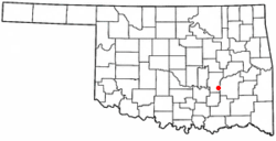
Stuart is located in southeastern Hughes County at 34°54′3″N96°6′0″W / 34.90083°N 96.10000°W / 34.90083; -96.10000 (34.900839, -96.100035). [6] U.S. Route 270 passes just north of the town, leading east 20 miles (32 km) to McAlester and west 10 miles (16 km) to Calvin. Holdenville, the Hughes county seat, is 27 miles (43 km) to the northwest via US 270.

According to the United States Census Bureau, Stuart has a total area of 0.3 square miles (0.7 km2), all land. [4] Coal Creek runs through the northwest corner of the town, flowing east toward Eufaula Lake on the Canadian River.

Demographics

Historical population
CensusPop.Note
1930 535
1940 340−36.4%
1950 303−10.9%
1960 271−10.6%
1970 2948.5%
1980 235−20.1%
1990 228−3.0%
2000 220−3.5%
2010 180−18.2%
2020 1926.7%
U.S. Decennial Census [7]

As of the census [2] of 2000, there were 220 people, 92 households, and 65 families residing in the town. The population density was 797.1 inhabitants per square mile (307.8/km2). There were 107 housing units at an average density of 387.7 per square mile (149.7/km2). The racial makeup of the town was 84.55% White, 13.18% Native American, and 2.27% from two or more races. Hispanic or Latino of any race were 4.09% of the population.

There were 92 households, out of which 31.5% had children under the age of 18 living with them, 60.9% were married couples living together, 7.6% had a female householder with no husband present, and 29.3% were non-families. 29.3% of all households were made up of individuals, and 16.3% had someone living alone who was 65 years of age or older. The average household size was 2.39 and the average family size was 2.95.

In the town, the population was spread out, with 23.6% under the age of 18, 8.6% from 18 to 24, 25.9% from 25 to 44, 18.2% from 45 to 64, and 23.6% who were 65 years of age or older. The median age was 40 years. For every 100 females, there were 113.6 males. For every 100 females age 18 and over, there were 97.6 males.

The median income for a household in the town was $22,222, and the median income for a family was $29,375. Males had a median income of $22,250 versus $21,250 for females. The per capita income for the town was $11,569. About 18.8% of families and 20.5% of the population were below the poverty line, including 28.6% of those under the age of eighteen and none of those 65 or over.

Economy

According to the Encyclopedia of Oklahoma History and Culture, 93.6 percent of Stuart's employed residents commute to jobs in other cities and towns. [5] There are no large-scale employers in Stuart.

Education

Stuart Public Schools is the school district of the town. It operates a single school, Stuart Public School. which teaches pupils from pre-kindergarten through high school. [5]

Notes

  1. The settlement was named for a Choctaw allottee. [5]

Related Research Articles

<span class="mw-page-title-main">Pittsburg County, Oklahoma</span> County in Oklahoma, United States

Pittsburg County is a county located in the U.S. state of Oklahoma. As of the 2020 census, the population was 43,773. Its county seat is McAlester. The county was formed from part of the Choctaw Nation in Indian Territory in 1907. County leaders believed that its coal production compared favorably with Pittsburgh, Pennsylvania at the time of statehood.

<span class="mw-page-title-main">Latimer County, Oklahoma</span> County in Oklahoma, United States

Latimer County is a county located in the southeastern part of the U.S. state of Oklahoma. Its county seat is Wilburton. As of the 2020 census, the population was 9,444. The county was created at statehood in 1907 and named for James L. Latimer, a delegate from Wilburton to the 1906 state Constitutional Convention. Prior to statehood, it had been for several decades part of Gaines County, Sugar Loaf County, and Wade County in the Choctaw Nation.

<span class="mw-page-title-main">Hughes County, Oklahoma</span> County in Oklahoma, United States

Hughes County is a county located in south central U.S. state of Oklahoma. As of the 2020 census, the population was 13,367. Its county seat is Holdenville. The county was named for W. C. Hughes, an Oklahoma City lawyer who was a member of the Oklahoma Constitutional Convention.

Kinta is a town in Haskell County, Oklahoma, United States. The population was 297 at the 2010 census, an increase of 22.2 percent over the figure of 243 recorded in 2000.

<span class="mw-page-title-main">Atwood, Oklahoma</span> Town in Oklahoma, United States

Atwood is a town in Hughes County, Oklahoma, United States. The population was 74 at the 2010 census.

<span class="mw-page-title-main">Calvin, Oklahoma</span> Town in Oklahoma, United States

Calvin is a town in Hughes County, Oklahoma, United States. The population was 294 at the 2010 census.

<span class="mw-page-title-main">Gerty, Oklahoma</span> Town in Oklahoma, United States

Gerty is a town in southern Hughes County, Oklahoma, United States. The population was 118 at the 2010 census.

<span class="mw-page-title-main">Holdenville, Oklahoma</span> City in Oklahoma, United States

Holdenville is a city in and county seat of Hughes County, Oklahoma, United States. The population was 5,771 at the 2010 census, an increase of 22 percent from 4,732 at the 2000 census.

<span class="mw-page-title-main">Horntown, Oklahoma</span> Town in Oklahoma, United States

Horntown is a town in Hughes County, Oklahoma, United States. The population was 97 at the 2010 census, up from the figure of 61 recorded in 2000.

<span class="mw-page-title-main">Lamar, Oklahoma</span> Town in Oklahoma, United States

Lamar is a town in Hughes County, Oklahoma, United States. The population was 158 at the 2010 census.

<span class="mw-page-title-main">Spaulding, Oklahoma</span> Town in Oklahoma, United States

Spaulding is a town in Hughes County, Oklahoma, United States. Although it was initially established at the turn of the 20th century, it did not incorporate as a town until 1978. The population was 178 at the 2010 census, up from 62 in 2000, when the town's area was approximately one-third of its 2010 area.

<span class="mw-page-title-main">Wetumka, Oklahoma</span> City in Oklahoma, United States

Wetumka is a city in northern Hughes County, Oklahoma, United States. The population was 1,282 at the 2010 census, a decline of 11.7 percent from the figure of 1,451 recorded in 2000. First settled by the Muscogee Creek after removal in the 1830s, they named it for their ancestral town of Wetumpka, in Alabama. Wetumka is a Muskogee language word meaning "rumbling waters."

<span class="mw-page-title-main">Wister, Oklahoma</span> Town in Oklahoma, United States

Wister is a town in Le Flore County, Oklahoma, United States. It is part of the Fort Smith metropolitan area. The population was 1,102 at the 2010 census. Wister is named for Gutman G. Wister, an official with the Choctaw, Oklahoma and Gulf Railroad.

<span class="mw-page-title-main">Haileyville, Oklahoma</span> City in Oklahoma, United States

Haileyville is a city in Pittsburg County, Oklahoma, United States. The population was 813 at the 2010 census.

<span class="mw-page-title-main">Hartshorne, Oklahoma</span> City in Oklahoma, United States

Hartshorne is a city in Pittsburg County, Oklahoma, United States. It is the second largest city in the county. The population was 2,125 at the 2010 census.

<span class="mw-page-title-main">Indianola, Pittsburg County, Oklahoma</span> Town in Oklahoma, United States

Indianola is a town in Pittsburg County, Oklahoma, United States. The population was 162 at the 2010 census, a loss of 15.2 percent compared to 191 at the 2000 census.

<span class="mw-page-title-main">Kiowa, Oklahoma</span> Town in Oklahoma, United States

Kiowa is a town in Pittsburg County, Oklahoma, United States. The population was 731 at the 2010 census.

<span class="mw-page-title-main">McAlester, Oklahoma</span> City in Oklahoma, United States

McAlester is the county seat of Pittsburg County, Oklahoma. The population was 18,363 at the time of the 2010 census, a 3.4 percent increase from 17,783 at the 2000 census. The town gets its name from James Jackson McAlester, an early white settler and businessman who later became lieutenant governor of Oklahoma. Known as "J. J.", McAlester married Rebecca Burney, the daughter of a full-blood Chickasaw family, which made him a citizen of the Chickasaw Nation.

<span class="mw-page-title-main">Savanna, Oklahoma</span> Town in Oklahoma, United States

Savanna is a town in Pittsburg County, Oklahoma, United States. The population was 686 at the 2010 census, a decline of 6.0 percent from the figure of 730 recorded in 2000. It is the hometown of former Harlem Globetrotter and 2014 NAIA Dunk Champion Tyler Inman.

Allen is a town in Hughes and Pontotoc counties in the U.S. state of Oklahoma. The population was 932 at the 2010 census.

References

  1. "ArcGIS REST Services Directory". United States Census Bureau. Retrieved September 20, 2022.
  2. 1 2 "U.S. Census website". United States Census Bureau . Retrieved January 31, 2008.
  3. "US Board on Geographic Names". United States Geological Survey. October 25, 2007. Retrieved January 31, 2008.
  4. 1 2 "Geographic Identifiers: 2010 Census Summary File 1 (G001): Stuart town, Oklahoma". American Factfinder. U.S. Census Bureau. Archived from the original on February 13, 2020. Retrieved January 17, 2018.
  5. 1 2 3 4 5 6 7 enc/entry.php?entry=ST054 Wilson, Linda D. "Stuart." Encyclopedia of History and Culture. Accessed July 6, 2019.
  6. "US Gazetteer files: 2010, 2000, and 1990". United States Census Bureau. February 12, 2011. Retrieved April 23, 2011.
  7. "Census of Population and Housing". Census.gov. Retrieved June 4, 2015.