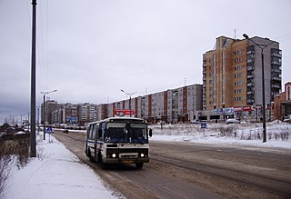
Kirovo-Chepetsk is a town in Kirov Oblast, Russia, located at the confluence of the Cheptsa and the Vyatka Rivers, 20 kilometers (12 mi) east of Kirov. Population: 80,921 (2010 Census); 90,303 (2002 Census); 92,382 (1989 Census).

Luza is a town and the administrative center of Luzsky District in Kirov Oblast, Russia, located on the Luza River, 301 kilometers (187 mi) northwest of Kirov, the administrative center of the oblast. Population: 11,260 (2010 Census); 12,311 (2002 Census); 13,706 (1989 Census).

Murashi is a town and the administrative center of Murashinsky District in Kirov Oblast, Russia, located 112 kilometers (70 mi) northwest of Kirov, the administrative center of the oblast, on the Kirov–Syktyvkar highway. Population: 6,750 (2010 Census); 7,650 (2002 Census); 10,059 (1989 Census).

Kiknursky District is an administrative and municipal district (raion), one of the thirty-nine in Kirov Oblast, Russia. It is located in the southwest of the oblast. The area of the district is 1,680 square kilometers (650 sq mi). Its administrative center is the urban locality of Kiknur. Population: 9,795 (2010 Census); 13,228 ; 16,347 (1989 Census). The population of Kiknur accounts for 50.7% of the district's total population.

Kilmezsky District is an administrative and municipal district (raion), one of the thirty-nine in Kirov Oblast, Russia. It is located in the southeast of the oblast. The area of the district is 3,106.4 square kilometers (1,199.4 sq mi). Its administrative center is the urban locality of Kilmez. Population: 13,086 (2010 Census); 16,132 ; 18,370 (1989 Census). The population of Kilmez accounts for 45.5% of the district's total population.

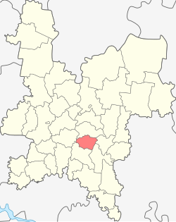
Kirovo-Chepetsky District is an administrative and municipal district (raion), one of the thirty-nine in Kirov Oblast, Russia. It is located in the center of the oblast. The area of the district is 2,210.27 square kilometers (853.39 sq mi). Its administrative center is the town of Kirovo-Chepetsk. Population: 21,317 (2010 Census); 22,193 ; 39,688 (1989 Census).

Kotelnichsky District is an administrative and municipal district (raion), one of the thirty-nine in Kirov Oblast, Russia. It is located in the west of the oblast. The area of the district is 3,940 square kilometers (1,520 sq mi). Its administrative center is the town of Kotelnich. Population: 15,799; (2010 Census) 20,507 ; 27,712 (1989 Census).

Kumyonsky District is an administrative and municipal district (raion), one of the thirty-nine in Kirov Oblast, Russia. It is located in the center of the oblast. The area of the district is 1,911 square kilometers (738 sq mi). Its administrative center is the urban locality of Kumyony. Population: 17,350 (2010 Census); 19,472 ; 21,445 (1989 Census). The population of Kumyony accounts for 27.8% of the district's total population.

Lebyazhsky District is an administrative and municipal district (raion), one of the thirty-nine in Kirov Oblast, Russia. It is located in the south of the oblast. The area of the district is 1,336 square kilometers (516 sq mi). Its administrative center is the urban locality of Lebyazhye. Population: 8,700 (2010 Census); 11,176 ; 12,414 (1989 Census). The population of Lebyazhye accounts for 38.6% of the district's total population.
Murashinsky District is an administrative and municipal district (raion), one of the thirty-nine in Kirov Oblast, Russia. It is located in the north of the oblast. The area of the district is 3,415.78 square kilometers (1,318.84 sq mi). Its administrative center is the town of Murashi. As of the 2010 Census, the total population of the district was 12,905, with the population of Murashi accounting for 52.3% of that number.

Nemsky District is an administrative and municipal district (raion), one of the thirty-nine in Kirov Oblast, Russia. It is located in the southeast of the oblast. The area of the district is 2,158 square kilometers (833 sq mi). Its administrative center is the urban locality of Nema. As of the 2010 Census, the total population of the district was 7,983, with the population of Nema accounting for 45.7% of that number.
Oparinsky District is an administrative and municipal district (raion), one of the thirty-nine in Kirov Oblast, Russia. It is located in the northwest of the oblast. The area of the district is 6,043 square kilometers (2,333 sq mi). Its administrative center is the urban locality of Oparino. Population: 11,795 (2010 Census); 14,631 ; 18,201 (1989 Census). The population of Oparino accounts for 37.6% of the district's total population.
Orichevsky District is an administrative and municipal district (raion), one of the thirty-nine in Kirov Oblast, Russia. It is located in the center of the oblast. The area of the district is 2,352 square kilometers (908 sq mi). Its administrative center is the urban locality of Orichi. Population: 30,781 (2010 Census); 32,764 ; 36,425 (1989 Census). The population of Orichi accounts for 25.9% of the district's total population.

Pizhansky District is an administrative and municipal district (raion), one of the thirty-nine in Kirov Oblast, Russia. It is located in the southwest of the oblast. The area of the district is 1,160.2 square kilometers (448.0 sq mi). Its administrative center is the urban locality of Pizhanka. Population: 11,242 (2010 Census); 13,580 ; 15,220 (1989 Census). The population of Pizhanka accounts for 34.5% of the district's total population.

Podosinovsky District is an administrative and municipal district (raion), one of the thirty-nine in Kirov Oblast, Russia. It is located in the northwest of the oblast. The area of the district is 4,265 square kilometers (1,647 sq mi). Its administrative center is the urban locality of Podosinovets. Population: 17,009 (2010 Census); 21,649 ; 25,559 (1989 Census). The population of Podosinovets accounts for 23.7% of the district's total population.

Tuzhinsky District is an administrative and municipal district (raion), one of the thirty-nine in Kirov Oblast, Russia. It is located in the southwest of the oblast. The area of the district is 1,468 square kilometers (567 sq mi). Its administrative center is the urban locality of Tuzha. Population: 7,688 (2010 Census); 10,396 ; 12,334 (1989 Census). The population of Tuzha accounts for 59.4% of the district's total population.

Urzhumsky District is an administrative and municipal district (raion), one of the thirty-nine in Kirov Oblast, Russia. It is located in the south of the oblast. The area of the district is 3,025 square kilometers (1,168 sq mi). Its administrative center is the town of Urzhum. Population: 27,075 (2010 Census); 33,959 ; 38,836 (1989 Census). The population of Urzhum accounts for 37.7% of the district's total population.

Yuryansky District is an administrative and municipal district (raion), one of the thirty-nine in Kirov Oblast, Russia. It is located in the north of the oblast. The area of the district is 3,031 square kilometers (1,170 sq mi). Its administrative center is the urban locality of Yurya. Population: 20,128 (2010 Census); 22,893 ; 34,311 (1989 Census). The population of Yurya accounts for 28.2% of the district's total population.
Pervomaysky is a closed urban locality in Kirov Oblast, Russia. Population: 6,147(2010 Census); 9,300.

Arkul is an urban locality in Nolinsky District of Kirov Oblast, Russia. Population: 2,053 (2010 Census); 2,616 (2002 Census); 3,163 (1989 Census).