

The Tahoe–Pyramid Trail is a planned 114-mile (183 km) long-distance pedestrian and bicycle trail which will run between Lake Tahoe and Pyramid Lake, principally along the routing of the Truckee River.
The Tahoe–Pyramid Trail is a planned 114-mile (183 km) long-distance pedestrian and bicycle trail which will run between Lake Tahoe and Pyramid Lake, principally along the routing of the Truckee River.
The effort to construct a pedestrian path between the two connected lakes was started in November 2003, undertaken at first by Janet Phillips. [1] The organization responsible for planning and construction of the trail, Tahoe–Pyramid Bikeway, was formed in 2005 (the current name was adopted in 2018 to reflect its multi-use function). [2]
The western portion between Tahoe and the Reno–Sparks area opened to hikers on October 5, 2019, [1] completing the California section of the trail. As of October 2019 [update] , two sections are not complete: Vista Blvd to Mustang and USA Parkway to Wadsworth. The Porrtion to Mustang is blocked by landowner issues as of January 2018 [update] . [3]
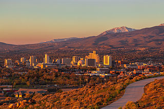
Reno is a city in the northwest section of the U.S. state of Nevada, along the Nevada–California border. It is the county seat and most populous city of Washoe County. Sitting in the High Eastern Sierra foothills, in the Truckee River valley, on the eastern side of the Sierra Nevada, it is about 23 miles (37 km) northeast of Lake Tahoe. Known as "The Biggest Little City in the World", it is the 80th most populous city in the United States, the 3rd most populous city in Nevada, and the most populous in Nevada outside the Las Vegas Valley. The city had a population of 264,165 at the 2020 census.

Sparks is a city in Washoe County, Nevada, United States. It was founded in 1904, incorporated on March 15, 1905, and is located just east of Reno. The 2020 U.S. Census counted 108,445 residents in the city. It is the fifth most populous city in Nevada. It is named after John Sparks, Nevada governor (1903–1908), and a member of the Silver Party.

Lake Tahoe is a freshwater lake in the Sierra Nevada of the Western United States, straddling the border between California and Nevada. Lying at 6,225 ft (1,897 m) above sea level, Lake Tahoe is the largest alpine lake in North America, and at 122,160,280 acre⋅ft (150.7 km3) it trails only the five Great Lakes as the largest by volume in the United States. Its depth is 1,645 ft (501 m), making it the second deepest in the United States after Crater Lake in Oregon.
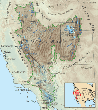
The Great Basin is the largest area of contiguous endorheic watersheds, those with no outlets to the ocean, in North America. It spans nearly all of Nevada, much of Utah, and portions of California, Idaho, Oregon, Wyoming, and Baja California. It is noted for both its arid climate and the basin and range topography that varies from the North American low point at Badwater Basin in Death Valley to the highest point of the contiguous United States, less than 100 miles (160 km) away at the summit of Mount Whitney. The region spans several physiographic divisions, biomes, ecoregions, and deserts.

Reno–Tahoe International Airport is a public and military airport three miles (4.8 km) southeast of downtown Reno, in Washoe County, Nevada, United States. It is the state's second busiest commercial airport after Harry Reid International Airport in Las Vegas. The Nevada Air National Guard has the 152nd Airlift Wing southwest of the airport's main terminal. The airport is named after both the City of Reno, Nevada and Lake Tahoe. The airspace of Reno-Tahoe Airport is controlled by the Northern California TRACON and Oakland Air Route Traffic Control Center.

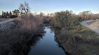
The Truckee River is a river in the U.S. states of California and Nevada. The river flows northeasterly and is 121 miles (195 km) long. The Truckee is the sole outlet of Lake Tahoe and drains part of the high Sierra Nevada, emptying into Pyramid Lake in the Great Basin. Its waters are an important source of irrigation along its valley and adjacent valleys.

Interstate 580 (I-580) is a 35.019-mile (56.358 km) auxiliary Interstate Highway in Western Nevada. It runs concurrently with US Route 395 (US 395) from an intersection with US 50 near the southern boundary of Carson City to the Reno Spaghetti Bowl interchange with I-80 in Reno. The freeway provides a high-speed direct route between Lake Tahoe and Carson City to Reno and I-80.

U.S. Route 50 (US 50) is a transcontinental United States Numbered Highway, stretching from West Sacramento, California, in the west to Ocean City, Maryland, in the east. The California portion of US 50 runs east from Interstate 80 (I-80) in West Sacramento to the Nevada state line in South Lake Tahoe. A portion in Sacramento also has the unsigned designation of Interstate 305. The western half of the highway in California is a four-or-more-lane divided highway, mostly built to freeway standards, and known as the El Dorado Freeway outside of downtown Sacramento. US 50 continues as an undivided highway with one eastbound lane and two westbound lanes until the route reaches the canyon of the South Fork American River at Riverton. The remainder of the highway, which climbs along and out of the canyon, then over the Sierra Nevada at Echo Summit and into the Lake Tahoe Basin, is primarily a two-lane road.

The Manhattan Waterfront Greenway is a waterfront greenway for walking or cycling, 32 miles (51 km) long, around the island of Manhattan, in New York City. The largest portions are operated by the New York City Department of Parks and Recreation. It is separated from motor traffic, and many sections also separate pedestrians from cyclists. There are three principal parts — the East, Harlem and Hudson River Greenways.

The Iron Horse Trail is a multi-use urban rail trail which connects the cities of Waterloo and Kitchener, Ontario, Canada. It runs from Erb Street West in the north near Uptown Waterloo, to Ottawa Street South in Kitchener to the south. It covers a distance of 5.5 kilometres (3.4 mi). The trail was opened on 5 October 1997 on abandoned Canadian Pacific Railway right of way sections, including portions of the right-of-way of the now-defunct Grand River Railway. The two cities combined resources to purchase the property. It is a part of the Trans Canada Trail.
The Guadalupe River Trail is an 11-mile (18 km) pedestrian and bicycle path in the city of San Jose, California. The path runs along the banks of the Guadalupe River. The trail is currently composed of two discontinuous segments: a shorter "upper" segment in the Almaden Valley neighborhood of San Jose and a longer "lower" segment through Downtown San Jose to Alviso. This trail is heavily used for both recreation and commuting, as it provides direct access to Downtown San Jose from many of the outlying neighborhoods. The trail is paved.

The Watertown Branch Railroad was a branch loop of the Fitchburg Railroad that was meant to serve the town of Watertown and the City of Waltham, Middlesex County, Massachusetts, as an independent short line railroad; it also serviced the Watertown Arsenal. The line has been formally abandoned and portions have been converted into a rail trail, the Watertown-Cambridge Greenway. A section from School Street to Arlington Street in Watertown was completed first. A small portion in Waltham has been converted into a park called Chemistry Station Park after the railroad station once located there. Construction of an extension to Fresh Pond Reservation in Cambridge began in the summer of 2018 and was completed in June 2022.

The Los Angeles River bicycle path is a Class I bicycle and pedestrian path in the Greater Los Angeles area running from north to east along the Los Angeles River through Griffith Park in an area known as the Glendale Narrows. The 7.4 mile section of bikeway through the Glendale Narrows is known as the Elysian Valley Bicycle & Pedestrian Path. The bike path also runs from the city of Vernon to Long Beach, California. This section is referred to as LARIO, or more formally, the Los Angeles River Bikeway.

The East River Greenway is an approximately 9.44-mile-long (15.19 km) foreshoreway for walking or cycling on the east side of the island of Manhattan on the East River. It is part of the Manhattan Waterfront Greenway. The largest portions are operated by the New York City Department of Parks and Recreation. It is separated from motor traffic, and many sections also separate pedestrians from cyclists. The greenway is parallel to the Franklin D. Roosevelt East River Drive for a majority of its length.

The James D. Pfluger Pedestrian and Bicycle Bridge is a shared use bridge for pedestrians and cyclists spanning Lady Bird Lake in downtown Austin, Texas. Opened in 2001, the bridge connects the north and south sides of the Ann and Roy Butler Hike-and-Bike Trail and features an unusual "double curve" design. The bridge runs parallel to the Lamar Boulevard Bridge, which carries road traffic across the lake roughly 200 feet (61 m) to the west.

The Western Gwinnett Bikeway is a multi-use trail under construction along Peachtree Industrial Boulevard in Gwinnett County. The trail will be 10 feet to 14 feet wide and traverse the cities of Norcross, Peachtree Corners, Berkeley Lake, Duluth, Suwanee, Sugar Hill and Buford. It is intended to be the spine of West Gwinnett’s trails and greenways, connecting parks, trails, businesses, schools and neighborhoods to the urban core.

The Cleveland Foundation Centennial Lake Link Trail, originally known as the Lake Link Trail, is a cycling, hiking, and walking trail located in the city of Cleveland, Ohio, in the United States. Owned by the city of Cleveland and maintained by Cleveland Metroparks, the trail runs along the former track bed of the Cleveland and Mahoning Valley Railroad. The trail is named for The Cleveland Foundation, a local community foundation which donated $5 million toward the trail's construction. The southern leg of the 1.3-mile (2.1 km) trail opened in August 2015, and the northern leg in August 2017. The middle leg will begin construction once the Irishtown Bend hillside is stabilized. A bridge connecting the trail to Whiskey Island will begin construction in Spring 2019 and will be completed in early Summer 2020.

The Rock Creek Trails are a series of trails through the Rock Creek valley and along the Potomac River in Washington, D.C., and Montgomery County, Maryland. The main route extends 22 miles from Lake Needwood in Maryland to the Inlet Bridge in Washington, D.C., with a loop in the north part of Rock Creek Park and other trails through the Klingle Valley, Turkey Branch Valley, and along the North Branch of Rock Creek. Three separate trails comprise the main Rock Creek Trail route; others connect to it. The section along the Potomac River from Arlington Memorial Bridge to Rock Creek is sometimes called the Shoreline Trail.

Hiawatha LRT Trail is a 4.7-mile (7.6 km), multi-use path adjacent to a light-rail transit line in Minneapolis, Minnesota, United States, that is popular with bicycle commuters. Users travel along the Metro Blue Line and Hiawatha Avenue transit corridor, reaching downtown Minneapolis near an indoor sports stadium at the trail’s northern end, and reaching a bridge above Minnehaha Creek at the trail’s southern end. Hiawatha LRT Trail provides a vital link between several Minneapolis neighborhoods and the city’s downtown area.
| | This United States trail or long-distance path–related article is a stub. You can help Wikipedia by expanding it. |
