
Hong Kong has a highly developed and sophisticated transport network, encompassing both public and private transport. Based on Hong Kong Government's Travel Characteristics Survey, over 90% of the daily journeys are on public transport, the highest rate in the world. However, in 2014 the Transport Advisory Committee, which advises the Government on transportation issues, issued a report on the much worsened congestion problem in Hong Kong and pointed at the excessive growth of private cars during the past 10–15 years.

Peng Chau is a small island located off the north-eastern coast of Lantau Island, Hong Kong. It is known locally for its temples, fishing industry and seafood.

Hong Kong Island is an island in the southern part of Hong Kong. It has a population of 1,289,500 and its population density is 16,390/km2, as of 2008. The island had a population of about 3,000 inhabitants scattered in a dozen fishing villages when it was occupied by the United Kingdom in the First Opium War (1839–1842). In 1842, the island was formally ceded in perpetuity to the UK under the Treaty of Nanking and the City of Victoria was then established on the island by the British Force in honour of Queen Victoria. The Central area on the island is the historical, political and economic centre of Hong Kong. The northern coast of the island forms the southern shore of the Victoria Harbour, which is largely responsible for the development of Hong Kong due to its deep waters favoured by large trade ships.

The Southern District is one of the 18 districts of Hong Kong. It is located in the southern part of Hong Kong Island. It had a population of 274,994 in 2016.

The Islands District is one of the 18 districts of Hong Kong. It is part of the New Territories. It had a population of 170,900 in 2018.

Tai Po District is one of the 18 districts of Hong Kong. The suburban district covers the areas of Tai Po New Town, Lam Tsuen Valley and other surrounding area, and its exclave in the northern part of the Sai Kung Peninsula. The Tai Po proper and North Sai Kung, was divided by the Tolo Channel and Tolo Harbour. The District is located in the Eastern New Territories. The de facto administrative centre of the district is Tai Po New Town.
Ma Wan is an island of Hong Kong, located between Lantau Island and Tsing Yi Island, with an area of 0.97 square kilometres. Administratively, it is part of Tsuen Wan District.

Hei Ling Chau, formerly Hayling Chau, is an island of Hong Kong, located east of Silver Mine Bay and Chi Ma Wan of Lantau Island. Administratively, it is part of the Islands District.

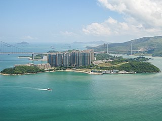
Ap Lei Chau or Aberdeen Island is an island of Hong Kong, located off Hong Kong Island next to Aberdeen Harbour and Aberdeen Channel. It has an area of 1.30 square kilometres (0.50 sq mi). Administratively, it is part of the Southern District. Ap Lei Chau is the 4th-most-densely-populated island in the world.
Tung Ping Chau is an island in Hong Kong, part of Hong Kong UNESCO Global Geopark. It was known as Ping Chau. Tung is prepended to the name so as to avoid possible confusion with Peng Chau, another island in Hong Kong with an identically pronounced name in the Cantonese language. Administratively, the island is part of the Tai Po District in the New Territories.
The Soko Islands are a group of islands in Hong Kong. The group consists of Tai A Chau, Siu A Chau and several smaller nearby islands, in the southwesternmost waters of the territory, to the southwest of Lantau Island.

Sok Kwu Wan or Picnic Bay is a bay on the east coast of Lamma Island, Hong Kong. A fishing town of the same name, Sok Kwu Wan, in the bay has a cluster of famous and well-reputed seafood restaurants near the ferry pier.
Siu A Chau is an uninhabited island of Hong Kong, part of the Soko Islands group, located south of Lantau Island.

Ap Lei Chau Bridge is a highway bridge in Hong Kong connecting the island of Ap Lei Chau to the community of Aberdeen on Hong Kong Island.
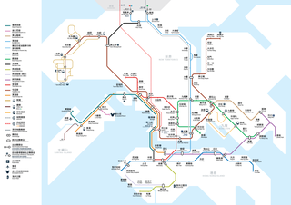
Several future projects on the MTR have been put forward by the MTR Corporation to the Hong Kong Government, with some already under construction. They are some finished, some building, some not started yet.
The Outlying Islands refers to all the islands that make up the territory of Hong Kong, with the exception of Hong Kong Island. There are 263 islands over 500 m2 in Hong Kong, the vast majority of which are located within the New Territories and significant numbers of them are located in Islands District in the south and southwest, Sai Kung District in the southeast, and Tai Po District and North District in the northeast. The term outlying is not strictly defined and in some cases islands very close to Hong Kong Island and mainland China are not included.
Articles related to Hong Kong include:

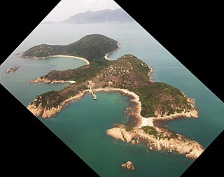
Tai Tau Chau is an island in the Southern District, Hong Kong. Geographically, it is located in the southern Hong Kong Island. It connected to the Shek O Headland by a footbridge and a gravelbar (tombolo) under it. The island itself is uninhabited.


