
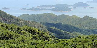
The Hong Kong Special Administrative Region of the People's Republic of China (HKSAR),can be geographically divided into three territories:Kowloon,Hong Kong Island,and the New Territories. Hong Kong is a coastal city and major port in Southern China,bordering Guangdong province through the city of Shenzhen to the north and the South China Sea to the west,east and south. Hong Kong and its 260 territorial islands and peninsulas are located at the mouth of the Pearl River Delta. The area of Hong Kong is distinct from Mainland China,but is considered part of "Greater China".

Peng Chau is a small island located off the north-eastern coast of Lantau Island,Hong Kong. It is known locally for its temples,fishing industry and seafood.

The Islands District is one of the 18 districts of Hong Kong. It is part of the New Territories. It had a population of 170,900 in 2018.

Tsing Yi,sometimes referred to as Tsing Yi Island,is an island in the urban area of Hong Kong,to the northwest of Hong Kong Island and south of Tsuen Wan. With an area of 10.69 km2 (4.13 sq mi),the island has extended drastically by reclamation along almost all its natural shore and the annexation of Nga Ying Chau (牙鷹洲) and Chau Tsai. Three major bays or harbours,Tsing Yi Lagoon,Mun Tsai Tong and Tsing Yi Bay (青衣灣) in the northeast,have been completely reclaimed for new towns.

Victoria Harbour is a natural landform harbour in Hong Kong separating Hong Kong Island in the south from the Kowloon Peninsula to the north. The harbour's deep,sheltered waters and strategic location on South China Sea were instrumental in Hong Kong's establishment as a British colony in 1841 and its subsequent development as a trading centre.
The Soko Islands are a group of islands in Hong Kong. The group consists of Tai A Chau,Siu A Chau and several smaller nearby islands,in the southwesternmost waters of the territory,to the southwest of Lantau Island.

Green Island is an island off the northwest coast of Kennedy Town,Hong Kong Island,separated by the Sulphur Channel. A smaller island nearby to the east,uninhabited,is called Little Green Island (小青洲). Administratively,the two islands are part of Central and Western District.

The Airport Core Programme (ACP) was a series of infrastructure projects centred on the new Hong Kong International Airport during the early 1990s. The programme was part of the Port and Airport Development Strategy,commonly known as the Rose Garden Project.
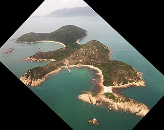
Siu A Chau is an uninhabited island of Hong Kong,part of the Soko Islands group,located south of Lantau Island.

Tsing Yi Peak,also known as Sam Chi Heung,is a hill with three peaks occupying the southern half of the Tsing Yi Island,Hong Kong. The hill is situated on the western half of Victoria Harbour. Its peaks are good locations to observe the harbour and the channels among harbour islands. While situated in the south,a short hill Liu To Shan occupies the northwest of the island.
Several future projects on the MTR have been put forward by the MTR Corporation to the Hong Kong Government. Some of these are still in planning stage,some are now completed.
Articles related to Hong Kong include:
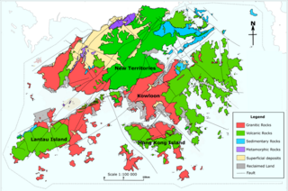
The geology of Hong Kong is dominated by igneous rocks formed during a major volcanic eruption period in the Mesozoic era. It made up 85% of Hong Kong's land surface and the remaining 15% are mostly sedimentary rocks located in the northeast New Territories. There are also a very small percentage of metamorphic rocks in New Territories. These are formed by deformation of pre-existing sedimentary rocks which changed its mineral assemblages (metamorphism).

Tsing Chau Tsai Peninsula is the peninsula located at the northeast of Lantau Island,New Territories,Hong Kong,including Yam O,To Kau Wan,Tai Tsing Chau,Tsing Chau Tsai and Penny's Bay.

The reclamation of land from the ocean has long been used in mountainous Hong Kong to expand the limited supply of usable land with a total of around 60 square kilometres of land created by 1996. The first reclamations can be traced back to the early Western Han Dynasty,when beaches were turned into fields for salt production. Major land reclamation projects have been conducted since the mid-19th century.

Peng Chau &Hei Ling Chau is one of the 10 constituencies in the Islands District in Hong Kong. The constituency returns one district councillor to the Islands District Council,with an election every four years.

Lantau Tomorrow Vision is a development project in Hong Kong proposed by the previous two Chief Executives of Hong Kong. The previous Chief Executive Carrie Lam proposed in her 2018 policy address which includes the creation of a third core business district by constructing artificial islands with a total area of about 1,700 hectares through massive land reclamation near Kau Yi Chau and Hei Ling Chau of the eastern waters of Lantau Island. The project has met with controversy and opposition for its high cost of estimated HK$500 billion –amounting to half of the city's fiscal reserves,as well as environmental concerns.


