Talco, Texas

Last updated

Talco, Texas
Talco City Hall3 (1 of 1).jpg
Talco City Hall, December 2019
TXMap-doton-Talco.PNG
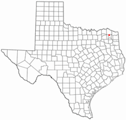
Location of Talco, Texas
Titus County Talco.svg
Coordinates: 33°21′46″N95°06′12″W / 33.36278°N 95.10333°W / 33.36278; -95.10333
Country United States
State Texas
County Titus
Area
[1]
  Total0.77 sq mi (1.99 km2)
  Land0.77 sq mi (1.98 km2)
  Water0.00 sq mi (0.00 km2)
Elevation
[2]
361 ft (110 m)
Population
 (2020)
  Total494
  Density640/sq mi (250/km2)
Time zone UTC-6 (Central (CST))
  Summer (DST) UTC-5 (CDT)
Zip Code
75487
Area code(s) 903, 430
FIPS code 48-71732 [3]
GNIS feature ID2412030 [2]

Talco is a town in Titus County, Texas, United States. The population was 494 at the 2020 census. The name is derived from a local candy bar (It was either a shelf carton or because the local people said it was "Texas-Arkansas-Louisiana Country hence Talco).[ citation needed ] Also reports said it may have been a local company name Texas-Arkansas-Louisiana Company.[ citation needed ]

Contents

History

Two post offices were established near the current site of Talco: Gouldsboro in 1856 and Goolesboro in 1878. Due to name conflict the community changed its name to "Talco" based on the Texas, Arkansas, and Louisiana Candy Company initials on a candy wrapper. In 1912, Talco relocated to be closer to a railroad line.

Oil was discovered in 1936, leading to a big boom in the economy. Talco called itself the "Asphalt capital of the world."

Geography

According to the United States Census Bureau, the city has a total area of 0.8 square mile (2.0 km2), all land.

US Route 271 is the major north–south highway passing through Talco. The community is one mile east of the Franklin County line.

Demographics

Historical population
CensusPop.Note
1940 912
1950 9170.5%
1960 1,02411.7%
1970 837−18.3%
1980 751−10.3%
1990 592−21.2%
2000 570−3.7%
2010 516−9.5%
2020 494−4.3%
U.S. Decennial Census [4]
Talco racial composition as of 2020 [5]
(NH = Non-Hispanic) [lower-alpha 1]
RaceNumberPercentage
White (NH)22044.53%
Black or African American (NH)8116.4%
Native American or Alaska Native (NH)61.21%
Some Other Race (NH)10.2%
Mixed/Multi-Racial (NH)306.07%
Hispanic or Latino 15631.58%
Total494

As of the 2020 United States census, there were 494 people, 258 households, and 206 families residing in the city.

Education

The City of Talco is served by the Rivercrest Independent School District (Talco-Bogata Consolidated Independent School District prior to July 1999). [8]

It previously maintained Talco Elementary. [9] The previous Talco school opened in 1939. [10] The district began construction of the consolidated elementary on May 1, 2000 and the scheduled completion was in June 2001. [8]

See also

Notes

  1. Note: the US Census treats Hispanic/Latino as an ethnic category. This table excludes Latinos from the racial categories and assigns them to a separate category. Hispanics/Latinos can be of any race. [6] [7]

Related Research Articles

<span class="mw-page-title-main">Primera, Texas</span> Town in Texas, United States

Primera is a town in Cameron County, Texas, United States, near Combes. The population was 5,257 at the 2020 census, up from 4,070 at the 2010 census. It is part of the Brownsville–Harlingen–Raymondville and the Matamoros–Brownsville metropolitan areas.

<span class="mw-page-title-main">Titus County, Texas</span> County in Texas, US

Titus County is a county located in the northeastern region of the U.S. state of Texas. As of the 2020 census, its population was 31,247. Its county seat is Mount Pleasant. The county is named for Andrew Jackson Titus, an early settler. Titus County comprises the Mount Pleasant micropolitan statistical area.

<span class="mw-page-title-main">Red River County, Texas</span> County in Texas, United States

Red River County is a county in the U.S. state of Texas. As of the 2020 census, its population was 11,587. Its county seat is Clarksville. The county was created in 1835 and organized in 1837. It is named for the Red River, which forms its northern boundary. Red River County was the birthplace of John Nance Garner, 32nd Vice President of the United States.

<span class="mw-page-title-main">Cass County, Texas</span> County in Texas, United States

Cass County is a county located in the U.S. state of Texas. As of the 2020 census, its population was 28,454. The county seat is Linden. The county was named for United States Senator Lewis Cass (D-Michigan), who favored the U.S. annexation of Texas in the mid-19th century.

<span class="mw-page-title-main">Bradley, Arkansas</span> City in Arkansas, United States

Bradley is a city in Lafayette County, Arkansas, United States. The population was 628 at the 2010 census.

<span class="mw-page-title-main">Keiser, Arkansas</span> City in Arkansas, United States

Keiser is a city in Mississippi County, Arkansas, United States. The population was 751 at the 2020 census.

<span class="mw-page-title-main">Luxora, Arkansas</span> City in Arkansas, United States

Luxora is a city in Mississippi County, Arkansas, United States. The population was 942 at the 2020 census, down from 1,178 in 2010.

<span class="mw-page-title-main">Wheatley, Arkansas</span> Town in Arkansas, United States

Wheatley is a town in southwest St. Francis County, Arkansas, United States. The population was 279 at the 2020 census, down from 355 in 2010.

Alto is a town in Cherokee County, Texas, United States. With a population of 1,027 at the 2020 U.S. census, Alto is the closest municipality to the Caddo Mounds State Historic Site, an archaeological site dating back to 800 BC, featuring a prehistoric village and ceremonial center.

<span class="mw-page-title-main">Corinth, Texas</span> City in Texas, United States

Corinth is a city in Denton County, Texas, United States; it is a part of the Dallas-Fort Worth metroplex. Its population was 22,634 at the 2020 census.

<span class="mw-page-title-main">Cross Roads, Texas</span> Town in Denton County, Texas, United States

Cross Roads is a town in Denton County, Texas, United States. The population was 1,744 in 2020.

<span class="mw-page-title-main">Spearman, Texas</span> City in Texas, United States

Spearman is a city in and the county seat of Hansford County, Texas, United States. As of the 2020 census, the city population was 3,171. It is known for its collection of windmills from the J.B. Buchanan windmill collection.

<span class="mw-page-title-main">Palmhurst, Texas</span> City in Texas

Palmhurst is a city in Hidalgo County, Texas, United States. The population was 2,607 at the 2010 United States Census. It is part of the McAllen–Edinburg–Mission and Reynosa–McAllen metropolitan areas.

<span class="mw-page-title-main">Sullivan City, Texas</span> City in Texas

Sullivan City is a city in Hidalgo County, Texas, United States. The population was 3,908 at the 2020 United States Census. It is part of the McAllen–Edinburg–Mission and Reynosa–McAllen metropolitan areas.

<span class="mw-page-title-main">Oak Ridge North, Texas</span> City in Montgomery County, Texas, United States

Oak Ridge North is a city in Montgomery County, Texas, United States. It is located along Interstate 45 10 miles (16 km) south of Conroe and 35 miles north of Houston. The population was 3,057 at the 2020 census.

<span class="mw-page-title-main">Lone Star, Texas</span> City in Texas, United States

Lone Star is a city in Morris County, Texas, United States. Its population was 1,581 at the 2010 census.

<span class="mw-page-title-main">Bogata, Texas</span> City in Texas, United States

Bogata is a city in Red River County, Texas, United States. The population was 1,074 at the 2020 census. The city was named after Bogotá, the capital of Colombia.

<span class="mw-page-title-main">Iowa Park, Texas</span> City in Texas, United States

Iowa Park is a city in Wichita County, Texas, United States. It is part of the Wichita Falls, Texas metropolitan statistical area. The population was 6,535 at the 2020 census.

Rivercrest Independent School District is a public school district based in Bogata, Texas (USA). Created in 1965, it was the Talco-Bogata Consolidated Independent School District until July 1999.

<span class="mw-page-title-main">Oark, Arkansas</span> Census-designated place in Arkansas, United States

Oark is an unincorporated community and census-designated place (CDP) in Johnson County, Arkansas, United States. Oark is located on Arkansas Highway 215, 16 miles (26 km) northwest of Clarksville. It was first listed as a CDP in the 2020 census with a population of 43.

References

  1. "2019 U.S. Gazetteer Files". United States Census Bureau. Retrieved August 7, 2020.
  2. 1 2 U.S. Geological Survey Geographic Names Information System: Talco, Texas
  3. "U.S. Census website". United States Census Bureau . Retrieved January 31, 2008.
  4. "Census of Population and Housing". Census.gov. Retrieved June 4, 2015.
  5. "Explore Census Data". data.census.gov. Retrieved May 21, 2022.
  6. https://www.census.gov/ [ not specific enough to verify ]
  7. "About the Hispanic Population and its Origin". www.census.gov. Retrieved May 18, 2022.
  8. 1 2 "Home". Rivercrest Independent School District. May 15, 2001. Archived from the original on May 15, 2001. Retrieved October 30, 2019.
  9. "Talco-Bogata Cons ISD Data". Texas Education Agency. May 4, 2001. Archived from the original on May 4, 2001. Retrieved October 30, 2019.
  10. "Home". Talco Elementary and Junior High. April 8, 2001. Archived from the original on April 8, 2001. Retrieved October 30, 2019.