Tamarack Peak (Washington)

Last updated
Tamarack Peak
Tamarack Peak, Washington state.jpg
Southeast aspect, centered
Highest point
Elevation 7,290 ft (2,222 m) [1] [2]
Prominence 1,033 ft (315 m) [2]
Parent peak Slate Peak (7,440 ft) [2]
Isolation 2.93 mi (4.72 km) [2]
Coordinates 48°46′24″N120°43′32″W / 48.7733023°N 120.7256306°W / 48.7733023; -120.7256306 [3]
Naming
Etymology Tamarack
Geography
USA Washington relief location map.jpg
Red triangle with thick white border.svg
Tamarack Peak
Location of Tamarack Peak in Washington
Usa edcp relief location map.png
Red triangle with thick white border.svg
Tamarack Peak
Tamarack Peak (the United States)
CountryUnited States
State Washington
County Okanogan / Whatcom
Protected area Pasayten Wilderness
Parent range Okanogan Range [1]
North Cascades
Cascade Range
Topo map USGS Pasayten Peak

Tamarack Peak is a 7,290-foot (2,222-metre) mountain summit located on the border shared by Okanogan County and Whatcom County in Washington state.

Contents

Description

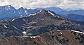
Tamarack Peak is part of the Okanogan Range which is a sub-range of the North Cascades. The mountain is situated 19 miles (31 km) northwest of Mazama on the boundary line of the Pasayten Wilderness, on land managed by the Okanogan–Wenatchee National Forest. The nearest higher peak is Pasayten Peak, 2.93 miles (4.72 km) to the east-northeast. [1] Precipitation runoff from Slate Peak's east slope drains to the Pasayten River, whereas the west slope drains into Barron Creek and the south slope into Bonita Creek which are both in the Skagit River drainage basin. Topographic relief is significant as the summit rises 2,300 feet (700 meters) above Barron Creek in 0.75 mile (1.2 km). Gold was discovered below Tamarack Peak in Bonita Creek by Alex Barron in 1892 and the boomtown of Barron sprang up. [4] The Pacific Crest Trail traverses the east slope of the peak. An ascent of the peak via this trail involves hiking 8.2 miles (round-trip) with 640-feet of elevation gain. [5] This mountain's toponym has been officially adopted by the U.S. Board on Geographic Names, [3] and refers to the larch tree, or tamarack, which is common in this area.

Tamarack Peak viewed from Slate Peak View North from Slate Peak; Tamarack Peak.jpg
Tamarack Peak viewed from Slate Peak

Climate

Most weather fronts originate in the Pacific Ocean, and travel northeast toward the Cascade Mountains. As fronts approach the North Cascades, they are forced upward by the peaks of the Cascade Range, causing them to drop their moisture in the form of rain or snowfall onto the Cascades (Orographic lift). As a result, the west side of the North Cascades experiences higher precipitation than the east side, especially during the winter months in the form of snowfall. During winter months, weather is usually cloudy, but due to high pressure systems over the Pacific Ocean that intensify during summer months, there is often little or no cloud cover during the summer. [6] July through October are the best months to visit in terms of favorable weather and the Forest Service access road being open for the season, [5] however, smoke from distant wildfires may potentially reduce visibility, and smoky summer conditions have been increasing with climate change. [7]

Geology

The North Cascades features some of the most rugged topography in the Cascade Range with craggy peaks, spires, ridges, and deep glacial valleys. Geological events occurring many years ago created the diverse topography and drastic elevation changes over the Cascade Range leading to the various climate differences.

The history of the formation of the Cascade Mountains dates back millions of years ago to the late Eocene Epoch. [8] With the North American Plate overriding the Pacific Plate, episodes of volcanic igneous activity persisted. [8] In addition, small fragments of the oceanic and continental lithosphere called terranes created the North Cascades about 50 million years ago. [8]

During the Pleistocene period dating back over two million years ago, glaciation advancing and retreating repeatedly scoured the landscape leaving deposits of rock debris. [8] The U-shaped cross section of the river valleys is a result of recent glaciation. Uplift and faulting in combination with glaciation have been the dominant processes which have created the tall peaks and deep valleys of the North Cascades area.

See also

Related Research Articles

<span class="mw-page-title-main">Monument Peak (Washington)</span> Mountain in Washington (state), United States

Monument Peak is an 8,597-foot (2,620-metre) mountain summit located in western Okanogan County in Washington state. It is part of the Okanogan Range which is a sub-range of the North Cascades. The mountain is situated in the Pasayten Wilderness, on land administered by the Okanogan–Wenatchee National Forest. The nearest higher peak is Mount Lago, 2.42 miles (3.89 km) to the north. Precipitation runoff from Monument Peak drains east into Monument Creek, and west into Eureka Creek, which are both part of the Methow River drainage basin.

<span class="mw-page-title-main">Robinson Mountain</span> Mountain in Washington (state), United States

Robinson Mountain is an 8,731-foot (2,661-metre) mountain summit located in western Okanogan County in Washington state. It is part of the Okanogan Range which is a sub-range of the North Cascades Range. The mountain is situated in the Pasayten Wilderness, on land administered by the Okanogan–Wenatchee National Forest. The nearest higher peak is Mount Lago, 7.28 miles (11.72 km) to the north. Precipitation runoff from Robinson Mountain drains west into Robinson Creek, and east into Eureka Creek, which are both part of the Methow River drainage basin. The mountain is named for brothers James and Thomas Robinson who were settlers in the area in the late 1800s.

<span class="mw-page-title-main">Cathedral Peak (Washington)</span> Mountain Peak in Washington

Cathedral Peak is an 8,606-foot (2,623-metre) mountain summit located in Okanogan County in Washington state. It is part of the Okanogan Range which is a sub-range of the North Cascades. The mountain is situated in the Pasayten Wilderness, on land administered by the Okanogan–Wenatchee National Forest. The nearest higher peak is Grimface Mountain, 2.6 miles (4.2 km) to the north in Cathedral Provincial Park in Canada. The Pacific Northwest Trail traverses below the south slope of Cathedral Peak as it crosses Cathedral Pass. Less than a mile to the opposite side of the pass stands Amphitheater Mountain. Precipitation runoff from Cathedral Peak drains west into Cathedral Fork, or east into Cathedral Creek.

<span class="mw-page-title-main">Amphitheater Mountain (Washington)</span> Mountain in Washington (state), United States

Amphitheater Mountain is an 8,358-foot (2,548-metre) multi-peak mountain located in Okanogan County in Washington state. It is part of the Okanogan Range which is a sub-range of the North Cascades and Cascade Range. The mountain is situated on the east side of the Cascade crest, in the Pasayten Wilderness, on land administered by the Okanogan–Wenatchee National Forest. The sprawling Amphitheater Mountain has several sub-peaks including the South Peak, West Peak, and North Peak. The nearest higher peak is Cathedral Peak, 0.95 miles (1.53 km) to the north. The Pacific Northwest Trail traverses below the north slope of Amphitheater Mountain as it crosses Cathedral Pass. Precipitation runoff from Amphitheater Mountain drains west into Cathedral Fork, or east into Cathedral Creek.

<span class="mw-page-title-main">Remmel Mountain</span> Mountain in Washington (state), United States

Remmel Mountain, also known as Mount Remmel, is a prominent 8,690-foot (2,650-metre) mountain summit located in Okanogan County in Washington state. It is the highest point in the Cathedral Range, which is a subrange of the Okanogan Range in the North Cascades. The mountain is situated 5 miles (8.0 km) south of the Canada–United States border, on the eastern side of the Cascade crest, in the Pasayten Wilderness, on land managed by the Okanogan–Wenatchee National Forest. The nearest higher peak is Mount Lago, 16.8 miles (27.0 km) to the west-southwest, and Amphitheater Mountain lies 3.6 miles (5.8 km) to the north. Remmel is the third-highest summit of the Okanogan Range following Mount Lago (8,745 ft), and Robinson Mountain (8,726 ft). These three peaks follow Jack Mountain {9,075 ft} as the highest peaks in the Pasayten Wilderness. Remmel is the most prominent mountain in the Pasayten Wilderness. Precipitation runoff from Remmel Mountain drains into the Chewuch River basin.

<span class="mw-page-title-main">Slate Peak</span> Mountain in Washington (state), United States

Slate Peak is a 7,440-foot (2,270-metre) mountain summit located on the shared border between Okanogan County and Whatcom County in Washington state. It is part of the Okanogan Range, which is a sub-range of the North Cascades. The mountain is situated 15 miles (24 km) northwest of Mazama, on the boundary line of the Pasayten Wilderness, on land managed by the Okanogan–Wenatchee National Forest. The peak has the distinction of having the highest road in Washington, as well as the highest fire lookout. Although the narrow one-lane white-knuckle road reaches the summit of the mountain, the Forest Service gated it to vehicles, which necessitates walking the final few hundred yards. Additionally, the Pacific Crest Trail traverses the west slope of the peak, and the West Fork Pasayten Trail traverses the eastern slope. The nearest higher peak is Devils Peak, 2.57 miles (4.14 km) to the north. Precipitation runoff from Slate Peak drains east into Pasayten River, or west into Slate Creek, which is in the Skagit River drainage basin.

<span class="mw-page-title-main">Sheep Mountain (Okanogan County, Washington)</span> Mountain in Washington (state), United States

Sheep Mountain is an 8,274-foot (2,522-metre) mountain summit located in Okanogan County in Washington state. It is part of the Okanogan Range which is a sub-range of the North Cascades and Cascade Range. The mountain is situated less than 2 miles (3.2 km) south of the Canada–United States border, on the east side of the Cascade crest, in the Pasayten Wilderness, on land managed by the Okanogan–Wenatchee National Forest. The nearest higher peak is Andrew Peak, 8.3 miles (13.4 km) to the east-southeast. The Pacific Northwest Trail traverses the slopes of Sheep Mountain as it crosses Peeve Pass. Precipitation runoff from Sheep Mountain drains west into Peeve Creek, or east into tributaries of Ashnola River. The mountain was so named because for 40 years the meadows surrounding it were prime grazing land for sheep in the summer, before the protection of wilderness designation.

<span class="mw-page-title-main">Apex Mountain (Okanogan County, Washington)</span> Mountain in Washington (state), United States

Apex Mountain is an 8,297-foot (2,529-metre) mountain summit located in Okanogan County in Washington state. It is part of the Okanogan Range which is a sub-range of the North Cascades and Cascade Range. The mountain is situated 2.5 miles (4.0 km) south of the Canada–United States border, on the east side of the Cascade crest, in the Pasayten Wilderness, on land managed by the Okanogan–Wenatchee National Forest. The nearest higher peak is Amphitheater Mountain, 2.35 miles (3.78 km) to the west-northwest. The Pacific Northwest Trail traverses the northern slopes of Apex Mountain as it crosses Apex Pass. Precipitation runoff from Apex Mountain drains west into Cathedral Creek, or east into Tungsten Creek, both tributaries of the Chewuch River.

<span class="mw-page-title-main">Windy Peak (Washington)</span> Mountain in Washington (state), United States

Windy Peak is an 8,333-foot (2,540-metre) mountain summit located in Okanogan County in Washington state. It is part of the Okanogan Range which is a sub-range of the North Cascades and Cascade Range. The mountain is situated 5 miles (8.0 km) south of the Canada–United States border, on the east side of the Cascade crest, in the Pasayten Wilderness, on land managed by the Okanogan–Wenatchee National Forest. The nearest higher peak is Haystack Mountain, 9.24 miles (14.87 km) to the northwest in Canada. Precipitation runoff from Windy Peak drains into tributaries of the Methow River and Similkameen River.

<span class="mw-page-title-main">Mount Lago</span> Mountain in Washington (state), United States

Mount Lago is a prominent 8,745-foot (2,665-metre) mountain summit located in the Okanogan Range of the North Cascades, in Okanogan County of Washington state. The mountain is situated on the eastern side of the Cascade crest, in the Pasayten Wilderness, on land managed by the Okanogan–Wenatchee National Forest. The nearest higher peak is Jack Mountain, 19.5 miles (31.4 km) to the west-southwest. Mount Lago is the highest summit of the Okanogan Range, and follows only Jack Mountain {9,075 ft} as the highest peak in the Pasayten Wilderness. Lago is the fourth-most prominent mountain in the Pasayten Wilderness. Precipitation runoff from the mountain drains into tributaries of the Pasayten River and Methow River. The mountain was named for Lage Wernstedt (1878-1959), a Forest Service surveyor who made numerous first ascents of the mountains he was mapping in the North Cascades. Lago, is a play on the way Americans pronounced his name. Lage, pronounced Loggy, had a son named Lago.

<span class="mw-page-title-main">Castle Peak (Washington)</span> Mountain in Washington (state), United States

Castle Peak is a prominent 8,306-foot (2,532-metre) mountain summit located in the Hozameen Range of the North Cascades, on the shared border between Okanogan County and Whatcom County of Washington state. The mountain is situated 1 mile (1.6 km) south of the Canada–United States border, on the Cascade crest, in the Pasayten Wilderness, on land managed by the Okanogan–Wenatchee National Forest. The nearest higher peak is Jack Mountain, 14.8 miles (23.8 km) to the south-southwest. Castle Peak is the second highest summit of the Hozameen Range following Jack Mountain. Castle Peak is the fifth-most prominent mountain in the Pasaten Wilderness. Precipitation runoff from the mountain drains east into Castle Creek, a tributary of the Similkameen River, or west into tributaries of the Skagit River.

<span class="mw-page-title-main">Mount Carru</span> Mountain in Washington (state), United States

Mount Carru is an 8,595-foot (2,620-metre) mountain summit located in western Okanogan County in Washington state. It is the 7th highest peak of the Okanogan Range, which is a sub-range of the North Cascades. The mountain is situated in the Pasayten Wilderness, on land administered by the Okanogan–Wenatchee National Forest. The nearest higher peak is Mount Lago, 0.8 miles (1.3 km) to the east, and Osceola Peak stands 1 mile (1.6 km) west. The mountain has a steep north face, but the south slope is covered in scree which allows a nontechnical climbing ascent. Precipitation runoff from Mount Carru drains north into Lease Creek which is a tributary of the Pasayten River, or south into Eureka Creek, which is part of the Methow River drainage basin.

Osceola Peak is an 8,587-foot (2,617-metre) mountain summit located in western Okanogan County in Washington state. The mountain's name was officially adopted in 1972. Osceola is the 10th highest peak of the Okanogan Range, which is a sub-range of the North Cascades. Osceola Peak ranks 50th on Washington's highest 100 peaks, and 48th on the "Bulger List". The mountain is situated in the Pasayten Wilderness, on land managed by the Okanogan–Wenatchee National Forest. The nearest higher peak is Mount Carru, 1 mile (1.6 km) to the east. The mountain has a steep north face, but the south slope is covered in scree which allows a nontechnical climbing ascent. Precipitation runoff from Osceola Peak drains north into tributaries of the Similkameen River, or south into Eureka Creek, which is part of the Methow River drainage basin.

<span class="mw-page-title-main">Devils Peak (Washington)</span> Mountain in Washington (state), United States

Devils Peak is an 8,081-foot (2,463-metre) mountain summit located in western Okanogan County in Washington state. It is part of the Okanogan Range which is a sub-range of the North Cascades Range. The mountain is situated in the Pasayten Wilderness, on land administered by the Okanogan–Wenatchee National Forest. The nearest higher neighbor is Robinson Mountain, 1.88 miles (3.03 km) to the east-southeast, and Slate Peak is set 3.1 miles (5.0 km) to the west. Precipitation runoff from Devils Peak drains west into Robinson Creek, and east into Eureka Creek, which are both part of the Methow River drainage basin.

<span class="mw-page-title-main">Pasayten Peak</span> Mountain in Washington (state), United States

Pasayten Peak is a 7,850-foot (2,390-metre) pyramidal-shaped mountain summit located in western Okanogan County in Washington state. It is part of the Okanogan Range which is a sub-range of the North Cascades. The mountain is situated in the Pasayten Wilderness, on land administered by the Okanogan–Wenatchee National Forest. The nearest higher neighbor is Wildcat Mountain, 3 miles (4.8 km) to the east-southeast, and Slate Peak is set 3.7 miles (6.0 km) to the south. Pasayten Peak is the high point of Gold Ridge, and precipitation runoff from this peak drains into the West and Middle Forks of Pasayten River.

<span class="mw-page-title-main">Spratt Mountain</span> Mountain in Washington (state), United States

Spratt Mountain is a 7,258-foot (2,212-metre) mountain summit located in the North Cascades, in Whatcom County of Washington state. It is situated on the western side of the Cascade crest, at the western edge of the Pasayten Wilderness, on land managed by the Okanogan–Wenatchee National Forest. Spratt Mountain is part of the Hozameen Range, a subset of the North Cascades which also includes Skagit Peak four miles to the north, and Jack Mountain six miles to the south. Precipitation runoff from this mountain drains into Ross Lake via Three Fools Creek and Dry Creek.

<span class="mw-page-title-main">Tatie Peak</span> Mountain in Washington (state), United States

Tatie Peak is a 7,386-foot (2,251-metre) mountain summit located on the shared border between Okanogan County and Whatcom County in Washington state. It is part of the Okanogan Range, which is a sub-range of the North Cascades. The mountain is situated 2.6 miles (4.2 km) east of Mount Ballard, and 3.3 miles (5.3 km) south of Slate Peak, on land managed by the Okanogan–Wenatchee National Forest. The nearest higher neighbor is Syncline Mountain, 0.8 miles (1.3 km) to the south-southwest. The Pacific Crest Trail traverses the south slope of the peak, with an easy off-trail scramble to reach the summit. Precipitation runoff from Tatie Peak drains south into Trout Creek which is a tributary of the Methow River, or northwest into Slate Creek, which is part of the Skagit River drainage basin.

<span class="mw-page-title-main">Syncline Mountain</span> Mountain in Washington (state), United States

Syncline Mountain is a 7,560-foot (2,300-metre) mountain summit located on the shared border between Okanogan County and Whatcom County in Washington state. It is part of the Okanogan Range, which is a sub-range of the North Cascades, and is situated on land managed by the Okanogan–Wenatchee National Forest. Its nearest neighbor is Tatie Peak, 0.8 miles (1.3 km) to the north, and the nearest higher neighbor is Mount Ballard, 2.1 miles (3.4 km) to the west. The Pacific Crest Trail traverses the east slope of the peak, with an off-trail scramble to reach the summit. Precipitation runoff from Syncline Mountain drains east into Trout Creek which is a tributary of the Methow River, or northwest into Slate Creek, which is part of the Skagit River drainage basin. This unofficially named mountain features a conspicuous syncline, hence its descriptive name.

<span class="mw-page-title-main">Big Craggy Peak</span> Mountain in Washington (state), United States

Big Craggy Peak is a prominent 8,470-foot (2,580-metre) mountain summit located in western Okanogan County in Washington state, USA. It is part of the Okanogan Range which is a sub-range of the North Cascades. This remote mountain is situated 12.5 mi (20.1 km) north-northeast of Mazama, on land administered by the Okanogan–Wenatchee National Forest. Big Craggy has two subsidiary peaks, North Peak (8,205-ft), and West Craggy (8,366-ft), the latter set on the Pasayten Wilderness boundary. The nearest higher peak is Monument Peak, 10 miles (16 km) to the west-northwest. Big Craggy Peak ranks 61st on Washington's highest 100 peaks, and 62nd on the "Bulger List". Precipitation runoff from Big Craggy drains into Eightmile Creek which is a tributary of the Chewuch River.

<span class="mw-page-title-main">Majestic Mountain</span> Mountain in Washington (state), United States

Majestic Mountain is a 7,530-foot-elevation (2,300-meter) mountain summit located in Whatcom County in Washington state.

References

  1. 1 2 3 "Tamarack Peak, Washington". Peakbagger.com. Retrieved 2023-08-15.
  2. 1 2 3 4 "Tamarack Peak - 7,290' WA". listsofjohn.com. Retrieved 2023-08-15.
  3. 1 2 "Tamarack Peak". Geographic Names Information System . United States Geological Survey, United States Department of the Interior . Retrieved 2023-08-15.
  4. Nathan Barnes, Washington Wildflower Hikes: 50 Destinations, Mountaineers Books (2021), ISBN   9781680510966
  5. 1 2 Erik Molvar, Best Easy Day Hikes North Cascades, Rowman & Littlefield (2020), ISBN   9781493046553, p. 72.
  6. Beckey, Fred W. Cascade Alpine Guide, Climbing and High Routes. Seattle, WA: Mountaineers Books, 2008.
  7. "Paul Lindholdt: Wildfires signal climate in calamity | the Spokesman-Review".
  8. 1 2 3 4 Kruckeberg, Arthur (1991). The Natural History of Puget Sound Country. University of Washington Press.