
Martha's Vineyard, often simply called the Vineyard, is an island in the U.S. state of Massachusetts, lying just south of Cape Cod. It is known for being a popular, affluent summer colony, and includes the smaller peninsula Chappaquiddick Island. It is the 58th largest island in the U.S., with a land area of about 96 square miles (250 km2), and the third-largest on the East Coast, after Long Island and Mount Desert Island. Martha's Vineyard constitutes the bulk of Dukes County, Massachusetts, which also includes the Elizabeth Islands and the island of Nomans Land.
Chilmark is a town located on Martha's Vineyard in Dukes County, Massachusetts, United States. The population was 1,212 at the 2020 census. The fishing village of Menemsha is located on the western side of the town along its border with the town of Aquinnah. Chilmark had the highest median home sale price of any town or city in Massachusetts in 2013.
Edgartown is a town on the island of Martha's Vineyard in Dukes County, Massachusetts, United States, for which it is the county seat. The town's population was 5,168 at the 2020 census.

Oak Bluffs is a town located on the island of Martha's Vineyard in Dukes County, Massachusetts, United States. The population was 5,341 at the 2020 United States Census. It is one of the island's principal points of arrival for summer tourists, and is noted for its "gingerbread cottages" and other well-preserved mid- to late-nineteenth-century buildings. The town has been a historically important center of African American culture since the eighteenth century.
Tisbury is a town located on Martha's Vineyard in Dukes County, Massachusetts, United States. The population was 4,815 at the 2020 census.

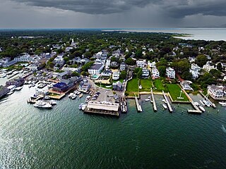
Vineyard Haven is a community within the town of Tisbury, Massachusetts, United States on the island of Martha's Vineyard. It is listed as a census-designated place (CDP) by the U.S. Census Bureau, with a population of 2,114 as of the 2010 census.

West Tisbury is a town located on Martha's Vineyard in Dukes County, Massachusetts, United States. The population was 3,555 at the 2020 census. Along with Chilmark and Aquinnah, West Tisbury forms "Up-Island" Martha's Vineyard.
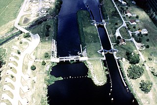
The Okeechobee Waterway or Okeechobee Canal is a relatively shallow artificial waterway in the United States, stretching across Florida from Fort Myers on the west coast to Stuart on Florida's east coast. The waterway can support tows such as barges or private vessels up to 50 feet wide x 250 feet long which draw less than 10 feet, as parts of the system, especially the locks may have low water depths of just ten feet. The system of channels runs through Lake Okeechobee and consists of the Caloosahatchee River to the west of the lake and the St. Lucie Canal east of the lake.

The Woods Hole, Martha's Vineyard and Nantucket Steamship Authority, doing business as The Steamship Authority (SSA), is the statutory regulatory body for all ferry operations between mainland Massachusetts and the islands of Martha's Vineyard and Nantucket, as well an operator of ferry services between the mainland and the islands. It is the only ferry operator to carry automobiles to and from the islands. The Authority also operates several freight vessels, thus serving as the main link for shipping any commercial goods that are not transported using the airports on Nantucket or Martha's Vineyard.

West Chop is a residential area located in the town of Tisbury, Massachusetts on the north end of the island of Martha's Vineyard. It is a peninsula surrounded on the north and west by Vineyard Sound and on the east by Vineyard Haven Harbor. A lighthouse, West Chop Light, stands at the north end of the chop. It is accessible by car from Vineyard Haven by two roads, Franklin Street and Main Street.

West Chop Light is a lighthouse station located at the entrance of Vineyard Haven Harbor in Tisbury, Massachusetts, on the northern tip of West Chop, a few miles from the village of Vineyard Haven.

East Chop Light is a historic lighthouse standing on a bluff overlooking Vineyard Haven Harbor and Vineyard Sound, located along East Chop Drive in the town of Oak Bluffs, Massachusetts. It is one of five lighthouses located on the island of Martha's Vineyard.

The William Street Historic District is a historic district in Vineyard Haven, Massachusetts, on the island of Martha's Vineyard. The district includes houses on William Street from Woodlawn Avenue in the north to several houses south of Camp Street. It represents the single best preserved area of mid 19th century houses in Vineyard Haven.

The West Chop Club Historic District is a historic district in Tisbury, Massachusetts, on the island of Martha's Vineyard. The district represents a well-preserved planned summer resort community of the late 19th century. Located in and around Iroquois Avenue, the district encompasses the northernmost portion of West Chop, a peninsula that separates Vineyard Sound and the sheltered waters of Vineyard Haven Harbor, an area that was developed by the West Chop Land Company in the 1880s. The land is now owned by the West Chop Land Trust and managed by the private West Chop Club. The district was listed on the National Register of Historic Places in 2007.
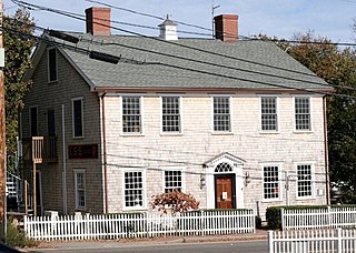
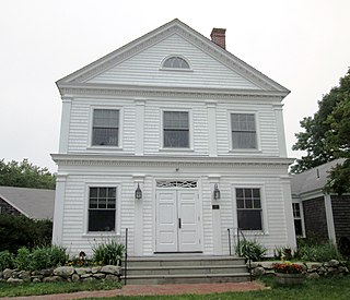
The Ritter House is an historic house on Beach Street in Vineyard Haven, Massachusetts, USA, and is listed on the National Register of Historic Places. The house is one of the few remaining Federal period buildings in Vineyard Haven. It has had a succession of occupants and uses, and as of 2007 served as a retail establishment.

The Falmouth Pumping Station is a historic water pumping station on Pumping Station Road in Falmouth, Massachusetts. The complex consists of an 1898 Queen Anne pumping station designed by Ernest N. Boyden, a low-lift pump and water treatment building built in 1993, a chlorination tank also built in 1993, and a house and garage added in 1932. The plant was built in response to rising demand for vacation properties and fire suppression, and continues to fulfill those functions today. The complex was listed on the National Register of Historic Places in 1998.

The Mystic Water Works, also called the Mystic Pumping Station, is a historic water works at Alewife Brook Parkway and Capen Street in Somerville, Massachusetts. Built in 1862–65 by the city of Charlestown, it is a significant example of a mid-19th century waterworks facility. The building has been listed twice on the National Register of Historic Places. The first, in 1989, is part of the city of Somerville's listings, and was made under the name "Mystic Water Works". The second is part of an umbrella listing covering the entire historic water works system of Greater Boston, and was made in 1990, listed as the "Mystic Pumping Station".

Martha's Vineyard Transit Authority(VTA) is a bus transportation system serving Martha's Vineyard, Massachusetts. In addition to diesel buses, it has 19 electric buses charged at several points. The Edgartown facility has 700 kW solar panels and a 1.5 MWh battery adding to the bus power.

The Rutland Railroad Pumping Station is a historic water pumping facility at 43 Lake Street in the town of Alburgh, Vermont. Built in 1903, it is a rare example in Vermont of an early railroad-related water pumping facility. In use until the 1940s, it provided water needed for steam engines at rail facilities elsewhere in Alburgh. It is now owned by the town, and was listed on the National Register of Historic Places in 1999.
Pilot Hill is a mountain in Dukes County, Massachusetts. It is on Martha's Vineyard 1.8 miles (2.9 km) west of Vineyard Haven in the Town of Tisbury. Tashmoo Hill is located east-southeast of Pilot Hill.


