
Louisville International Airport is a public and military use public airport in Louisville in Jefferson County, Kentucky. The airport covers about 1,200 acres (4.9 km2) and has three runways. Its IATA airport code, SDF, is based on the airport's former name, Standiford Field. It has no regularly-scheduled international passenger flights, but it is a port of entry, as it handles numerous international cargo flights.

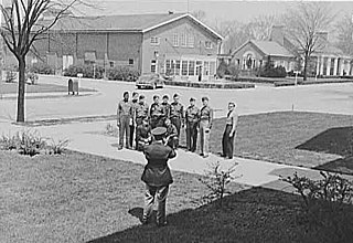
A barracks is a building or group of buildings built to house soldiers. The English word comes via French from an old Catalan word "barraca" (hut), originally referring to temporary shelters or huts for various people and animals, but today barracks are usually permanent buildings for military accommodation. The word may apply to separate housing blocks or to complete complexes, and the plural form often refers to a single structure and may be singular in construction.

Dobbins Air Reserve Base or Dobbins ARB is a United States Air Force reserve air base located in Marietta, Georgia, a suburb about 20 miles (32 km) northwest of Atlanta. Originally known as Dobbins Air Force Base, it was named in honor of Captain Charles M. Dobbins, a World War II C-47 pilot who died near Sicily.

DeKalb–Peachtree Airport is a county-owned, public-use airport in DeKalb County, Georgia, United States. The airport is located in the city of Chamblee, just northeast of Atlanta. It is also known commonly as Peachtree–DeKalb Airport, or simply PDK. Other names include Peachtree Airport, DeKalb Airport, or DeKalb County Airport. ASOS weather reports are produced 24 hours per day as "Chamblee". It has airline service with Ultimate Air Shuttle to Cincinnati and Southern Airways Express to Memphis and Destin.

Soto Cano Air Base is a Honduran military base 5 mi (8.0 km) to the south of Comayagua in Honduras. It houses between 500-600 U.S. troops and is also used by the Honduran Air Force academy. The airbase became operational in 1981, changing the old location of the Honduras Air Force Academy in Toncontin, Tegucigalpa to Palmerola. It serves as an important link to the US Military's presence in Central America.

The Jefferson Barracks Military Post is located on the Mississippi River at Lemay, Missouri, south of St. Louis. It was an important and active U.S. Army installation from 1826 through 1946. It is the oldest operating U.S. military installation west of the Mississippi River, and it is now used as a base for the Army and Air National Guard. A Veterans Affairs healthcare system campus is located on the southern portion of the base and is also the headquarters for the Veterans Canteen Service.

Airport Villa was a housing project that was once part of New Castle Air Force Base, in New Castle County, Delaware. It was built to house military personnel during the Korean War (1950–1953). In 1956, New Castle County purchased it from the U.S. Air Force and reopened it for civilian housing. Rentals of the houses were managed by the Harris-Hanby Real Estate Agency, New Castle, Delaware.
Fort Benjamin Harrison was a U.S. Army post located in suburban Lawrence Township, Marion County, Indiana, northeast of Indianapolis between 1906 and 1991. It is named for the 23rd United States President, Benjamin Harrison.

Plattsburgh Air Force Base is a former United States Air Force Strategic Air Command (SAC) base covering 3,447 acres (13.7 km²) in the extreme northeast corner of New York, 20 miles (32 km) south of the Canada–United States border, located on the western shore of Lake Champlain opposite Burlington, Vermont, in the city of Plattsburgh, New York.

Aldershot Garrison, also known as Aldershot Military Town, is a major garrison in South East England, located between Aldershot and Farnborough in Hampshire. Established in 1854, Aldershot is the home of the British Army although smaller than in previous years. The garrison was established when the War Department bought a large area of land near to the village of Aldershot, with the objective of establishing a permanent training camp for the British Army. Over time, this camp grew into a military town and continues to be used by the Army to the present day. It is home to the headquarters of the Army's Support Command, and it is also the administrative base for the 101st Logistic Brigade. The garrison plays host to around 70 military units and organisations.

Lunca de Sus is a commune in Harghita County, Romania. It lies in the Szekely Land, an ethno-cultural region in eastern Transylvania.

Bartow Municipal Airport is a public airport four miles (6 km) northeast of Bartow, in Polk County, Florida. It is owned by the Bartow Municipal Airport Development Authority.

China Bay Airport (Tamil: சீனக்குடா விமான நிலையம், translit. Cīṉakkuṭā Vimāṉa Nilaiyam; Sinhalese: චීන වරාය ගුවන්තොටුපළ, translit. Cīna Varāya Guvantoṭupaḷa; is an air force base and domestic airport in China Bay in eastern Sri Lanka. Located approximately 7 km south west of the city of Trincomalee, the airport is also known as Trincomalee Airport and SLAF China Bay.

Student housing at University of Florida is governed by the Division of Student Affairs, and provides housing for undergraduate, graduate, and professional students on and off-campus.
Khormaksar, is a city district in Aden Governorate, Yemen, with a population of 47,044 according to 2004 census.

Gjadër Air Base is a military airport located in Gjadër, Lezhë County, Albania. It is north of the city of Lezhë and is also known as Lezhë-Zadrima Air Base.

Saint-Dizier-Robinson Air Base is a front-line French Air Force (ALA) fighter base located approximately 4 km west of Saint-Dizier, in the Haute-Marne department of the Champagne-Ardenne region in northwestern France.

Fort Sumner Municipal Airport is a village owned, public use airport located two nautical miles (4 km) northeast of the central business district of Fort Sumner, a village in De Baca County, New Mexico, United States. It is included in the National Plan of Integrated Airport Systems for 2011–2015, which categorized it as a general aviation airport.
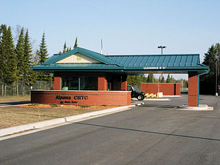
Alpena Combat Readiness Training Center is a Michigan Air National Guard training facility. It is located 7.1 miles (11.4 km) west-northwest of Alpena, Michigan.


