Taunton Green Historic District

Last updated

Taunton Green Historic District
Taunton green.jpg
Taunton Green, looking east toward Main Street
USA Massachusetts location map.svg
Red pog.svg
Usa edcp location map.svg
Red pog.svg
Location Taunton, Massachusetts
Coordinates 41°54′8″N71°5′40″W / 41.90222°N 71.09444°W / 41.90222; -71.09444
Area50 acres (20 ha)
Built1830 (1830)
ArchitectMultiple
Architectural styleLate 19th and 20th Century Revivals, Late Victorian
MPS Taunton MRA
NRHP reference No. 85000547 [1]
Added to NRHPMarch 1, 1985

The Taunton Green Historic District encompasses the core area of the historic 19th-century commercial downtown business district of Taunton, Massachusetts. It is centered on the town green, laid out in the 1740s, and now stands at the intersection of U.S. Route 44 and State routes 140 and 138. The district was listed on the National Register of Historic Places in 1985. [1]

Contents

History

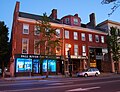
The early commercial center of the city of Taunton was southeast of the present center, at the confluence of the Taunton and Mill Rivers. In the 18th century early industry in the form of sawmills and gristmills developed on the Mill River. The Taunton Green was given to the town in 1743 as a militia training ground, and it is also where an early meetinghouse was built. Originally 88 acres (36 ha) in size, it is now much reduced by the surrounding development. Early commercial buildings were mostly of wood-frame construction, of which a few survive. [2]

Taunton Green has historically the gathering place for troops headed to war. [3] Monuments stand on the Green to honor soldiers of all the wars in which local citizens have participated. [3]

"Tauntonians" gathered on the Green on October 21, 1774, to raise the Taunton Flag with its distinctive "Liberty and Union" motto. [3] The flag was hoisted on a 112-foot liberty pole in defiance of King George III. [3] The flag flies on the Green to the present day. [3]

A fire in 1859 destroyed many buildings east of the green, and inaugurated more significant growth of brick buildings in the following decades. [2]

Since 1914 the Green has been the site of the city's annual holiday light display which attracts visitors from throughout the area, giving Taunton the nickname of "The Christmas City." [4] [3]

In July 2004, the historic Templar's Hall (c. 1850) and Cohannet Block (1870) (commonly referred to as the Seeley Building) located on the corner of Taunton Green and Weir Street were destroyed by an arsonist. [5]

Taunton Green (Massachusetts) Panorama.jpg
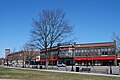
Daffodils and flowering trees brighten Taunton Green (Massachusetts) on a spring day

Description

County Courthouse and The Hiker statue Courthouse and The Hiker statue, Taunton Green.jpg
County Courthouse and The Hiker statue

The historic district is centered on the roughly square green, and includes most of the buildings facing the green on the flanking streets. It excludes the Bristol County Courthouse Complex, which is located on the north side of the green. [6] It extends for a short way along Broadway to the north and Main Street to the east.

Monuments on the Green honor soldiers of all the wars in which local citizens have participated. [3] Among them is The Hiker, one of fifty copies of a statue by Theo Alice Ruggles Kitson. It commemorates the American soldiers who fought in the Spanish–American War, the Boxer Rebellion and the Philippine–American War. The statue was cast by the Gorham Manufacturing Company in nearby Providence, Rhode Island.

Contributing properties

(partial listing)

Properties with separate NRHP Listings

See also

Related Research Articles

<span class="mw-page-title-main">Taunton, Massachusetts</span> City in Massachusetts, United States

Taunton is a city in Bristol County, Massachusetts, United States. It is the seat of Bristol County. Taunton is situated on the Taunton River which winds its way through the city on its way to Mount Hope Bay, 10 miles (16 km) to the south. At the 2020 census, the city had a population of 59,408. Shaunna O'Connell is the mayor of Taunton.

<span class="mw-page-title-main">New Haven Green</span> United States historic place

The New Haven Green is a 16-acre (65,000 m2) privately owned park and recreation area located in the downtown district of the city of New Haven, Connecticut, United States. It comprises the central square of the nine-square settlement plan of the original Puritan colonists in New Haven, and was designed and surveyed by colonist John Brockett. Today the Green is bordered by the modern paved roads of College, Chapel, Church, and Elm streets. Temple Street bisects the Green into upper (northwest) and lower (southeast) halves.

<span class="mw-page-title-main">Old Town Albuquerque</span> Historic townsite in New Mexico

Old Town is the historic original town site of Albuquerque, New Mexico, for the provincial kingdom of Santa Fe de Nuevo México, established in 1706 by New Mexico governor Francisco Cuervo y Valdés. It is listed on the New Mexico State Register of Cultural Properties as the Old Albuquerque Historic District, and is protected by a special historic zoning designation by the city. The present-day district contains about ten blocks of historic adobe buildings surrounding Old Town Plaza. On the plaza's north side stands San Felipe de Neri Church, a Spanish colonial church constructed in 1793.

<span class="mw-page-title-main">Old Colony History Museum</span> United States historic place

The Old Colony History Museum (OCHM) is located at 66 Church Green in Taunton, Bristol County, Massachusetts, United States. Since 1926, the museum has occupied the historic former Bristol Academy school building. The building was designed in 1852 by Richard Upjohn, architect of New York City's Trinity Church, and is listed on the National Register of Historic Places as part of the Church Green Historic District. The museum was previously located in the former Union Mission Chapel on Cedar Street.

<span class="mw-page-title-main">Bristol County Courthouse Complex</span> United States historic place

The Bristol County Courthouse Complex Historic District contains three historic buildings located along Court Street in Taunton, Massachusetts, including the Bristol County Superior Courthouse, the Bristol County Registry of Deeds and the former First District Courthouse. The city's Korean War and World War II Memorials are also located on the lawn in front of the superior courthouse. The Bristol County Courthouse Complex directly abuts the Taunton Green Historic District, the City's central square.

<span class="mw-page-title-main">Ogle County Courthouse</span> Local government building in the United States

The Ogle County Courthouse is a National Register of Historic Places listing in the Ogle County, Illinois, county seat of Oregon. The building stands on a public square in the city's downtown commercial district. The current structure was completed in 1891 and was preceded by two other buildings, one of which was destroyed by a group of outlaws. Following the destruction of the courthouse, the county was without a judicial building for a period during the 1840s. The Ogle County Courthouse was designed by Chicago architect George O. Garnsey in the Romanesque Revival style of architecture. The ridged roof is dominated by its wooden cupola which stands out at a distance.

<span class="mw-page-title-main">Downtown Santa Ana</span> United States historic place

Downtown Santa Ana (DTSA), also called Downtown Orange County, is the city center of Santa Ana, the county seat of Orange County, California. It is the institutional center for the city of Santa Ana as well as Orange County, a retail and business hub, and has in recent years developed rapidly as a regional cultural, entertainment and culinary center for Orange County.

<span class="mw-page-title-main">Church Green (Taunton, Massachusetts)</span> United States historic place

The Church Green is a town common in Taunton, Massachusetts. It is a triangular-shaped parcel of land located at the intersection of Summer Street and Dean Street. It has distinctive Veterans Memorials dedicated to both Vietnam Veterans and Global War on Terrorism Veterans. These memorials feature seven flags that are in a V shape, a fountain, a brick garden, reflection benches, the Vietnam Veterans Memorial and the Global War on Terrorism Memorial.

<span class="mw-page-title-main">United States Post Office–Taunton Main</span> United States historic place

US Post Office-Taunton Main is the main post office facility in the city center of Taunton, Massachusetts. Built in 1930 with funding from the Works Progress Administration, it is a fine example of Classical Revival architecture. The building was listed on the National Register of Historic Places in 1987; it was included in the Taunton Green Historic District in 1985.

<span class="mw-page-title-main">Spring Street (Los Angeles)</span> Historic district in Downtown Los Angeles

Spring Street in Los Angeles is one of the oldest streets in the city. Along Spring Street in Downtown Los Angeles, from just north of Fourth Street to just south of Seventh Street is the NRHP-listed Spring Street Financial District, nicknamed Wall Street of the West, lined with Beaux Arts buildings and currently experiencing gentrification. This section forms part of the Historic Core district of Downtown, together with portions of Hill, Broadway, Main and Los Angeles streets.

<span class="mw-page-title-main">Norwichtown</span> United States historic place

Norwichtown is a historic neighborhood in the city of Norwich, Connecticut. It is generally the area immediately north of the Yantic River between I-395 and Route 169.

<span class="mw-page-title-main">Warsaw Courthouse Square Historic District</span> Historic district in Indiana, United States

The Warsaw Courthouse Square Historic District is a historic district in Warsaw, Indiana that was listed on the National Register of Historic Places in 1982. Its boundaries were increased in 1993.

<span class="mw-page-title-main">Genesee County Courthouse Historic District</span> Historic district in New York, United States

The Genesee County Courthouse Historic District is located at the junction of Main, West Main and Ellicott streets in downtown Batavia, New York, United States. It is a small area with the county courthouse, a war memorial and other government buildings dating from the 1840s to the 1920s. Some were originally built for private purposes.

<span class="mw-page-title-main">Elbridge Boyden</span> American architect

Elbridge Boyden (1810–1898) was a prominent 19th-century American architect from Worcester, Massachusetts, who designed numerous civil and public buildings throughout New England and other parts of the United States. Perhaps his best known works are the Taunton State Hospital (1851) and Mechanics Hall (1855) in Worcester.

<span class="mw-page-title-main">Downtown Lafayette Historic District</span> Historic district in Indiana, United States

Downtown Lafayette Historic District is a national historic district located at Lafayette, Tippecanoe County, Indiana. Lafayette began in 1825 as a transportation center for the west central area of Indiana. Its development and growth reflects the changes in transportation over the intervening years. From its location along the Wabash River, it grew first with river travel then for a short while from the Wabash and Erie Canal. When the railroads arrived in the 1850s, the town began to grow, initially along the rail lines. The Downtown Lafayette Historic District reflects these early changes.

<span class="mw-page-title-main">Farmington Historic District (Farmington, Maine)</span> Historic district in Maine, United States

The Farmington Historic District encompasses much of the main central business district of Farmington, Maine. Farmington was settled in the 1770s, and experienced its most rapid growth after being named the shire town of Franklin County in 1838, with a secondary spurt of redevelopment after a major fire in the 1880s. Its central business district encompasses many of the town's historic resources, and its most significant commercial and civic architecture. The district, which includes more than 130 resource over 85 acres (34 ha), was listed on the National Register of Historic Places in 1995.

<span class="mw-page-title-main">George G. Adams (architect)</span> American architect (1850–1932)

George G. Adams was an American architect from Lawrence, Massachusetts.

<span class="mw-page-title-main">Flag of Taunton, Massachusetts</span> City flag of Taunton, Massachusetts, United States

The flag of Taunton, Massachusetts, also known as the Taunton Flag and the Liberty and Union Flag, is the city flag of Taunton, Massachusetts, United States. The flag was first adopted in 1774 and has since been adopted as the flag of Taunton. It consists of the Red Ensign with the flag of Great Britain in canton, defaced with the words "Liberty and Union" across the lower portion.

<span class="mw-page-title-main">Mount Pleasant Downtown Historic District</span> Historic district in Michigan, United States

The Mount Pleasant Downtown Historic District is a commercial historic district roughly bounded by Mosher, Franklin, Illinois and Washington Streets in Mount Pleasant, Michigan. It was listed on the National Register of Historic Places in 2014.

<span class="mw-page-title-main">Victorian Downtown Los Angeles</span> Historical neighborhood in California, US

The late-Victorian-era Downtown of Los Angeles in 1880 was centered at the southern end of the Los Angeles Plaza area, and over the next two decades, it extended south and west along Main Street, Spring Street, and Broadway towards Third Street. Most of the 19th-century buildings no longer exist, surviving only in the Plaza area or south of Second Street. The rest were demolished to make way for the Civic Center district with City Hall, numerous courthouses, and other municipal, county, state and federal buildings, and Times Mirror Square. This article covers that area, between the Plaza, 3rd St., Los Angeles St., and Broadway, during the period 1880 through the period of demolition (1920s–1950s).

References

  1. 1 2 "National Register Information System". National Register of Historic Places . National Park Service. April 15, 2008.
  2. 1 2 "MACRIS inventory record for Taunton Green Historic District". Commonwealth of Massachusetts. Retrieved January 16, 2017.
  3. 1 2 3 4 5 6 7 Hurwitz, Eric (May 1, 2016). Massachusetts Town Greens: A History of the State's Common Centers. Rowman & Littlefield. pp. 179–180. ISBN   9781493019281 . Retrieved January 17, 2017.
  4. Taunton Daily Gazette article, October 20, 2008
  5. Taunton Daily Gazette article 12/30/04 [ permanent dead link ]
  6. Walking Tours Taunton, Massachusetts; a guide to historic properties, Taunton Historic District Commission, 1998