Tehran Province is one of the 31 provinces of Iran. It covers an area of 18,814 square kilometres (7,264 sq mi) and is located to the north of the central plateau of Iran.

The Metropolitan Rapid Transit or MRT is a mass rapid transit system serving the Bangkok Metropolitan Region in Thailand. The MRT system comprises two rapid transit lines, with a further three lines currently under construction and due to open in 2022. The MRT Blue Line, officially the Chaloem Ratchamongkhon Line, between Hua Lamphong and Bang Sue was the first to open in 2004 as Bangkok's second metro system. The MRT Blue line is officially known in Thai as rotfaifa mahanakhon (รถไฟฟ้ามหานคร) or "metropolitan electric train", but it is more commonly called rotfai taidin (รถไฟใต้ดิน), literally, "underground train".

The South Luzon Expressway (SLEX), signed as E2 of the Philippine expressway network and R-3 of the Metro Manila arterial road network, is a limited-access toll expressway that connects Metro Manila to the provinces in the Calabarzon region on the island of Luzon in the Philippines. The expressway has a length of 46.9 km, traveling from its northern terminus at the Magallanes Interchange in Makati to its southern terminus at Santo Tomas, Batangas, connecting it to the Southern Tagalog Arterial Road. A portion of the expressway from the Magallanes Interchange to the Calamba Exit is part of Asian Highway 26 of the Asian highway network.

Azadi Square, formerly known as Shahyad Square, is a mainly green city square in Tehran, Iran. It hosts as its centerpiece the Azadi Tower. The tower and square were commissioned by Mohammad Reza Pahlavi, the last Shah of Iran, to mark the 2,500th year of the foundation of the Imperial State of Iran.

Tacubaya is a station on Lines 1, 7 and 9 of the Mexico City Metro system. It is located in the Miguel Hidalgo borough, west of the city centre. In 2019, the station had a total average ridership of 85,800 passengers per day, making it the fifth busiest station in the network.

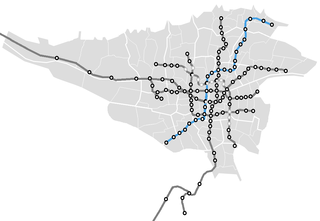
The Tehran Metro is a rapid transit system serving Tehran, the capital of Iran. It is the largest metro system in the Middle East. The system is owned and operated by Tehran Urban and Suburban Railway. It consists of six operational metro lines, with construction under way on three lines including west extension of line 4, line 6 and north and east extension line 7.

Rail transportation in the Philippines is currently used mostly to transport passengers within Metro Manila and the nearby province of Laguna, as well as a commuter service in the Bicol Region. Freight transport services once operated in the country, but these services were halted. However, there are plans to restore old freight services and build new lines. From a peak of 1,100 kilometers (680 mi), the country currently has a railway footprint of 533.14 kilometers (331.28 mi), of which only 129.85 kilometers (80.69 mi) are operational as of 2022, including all the urban rail lines. World War II, natural calamities, underspending, and neglect have all contributed to the decline of the Philippine railway network. In the 2019 Global Competitiveness Report, the Philippines has the lowest efficiency score among other Asian countries in terms of efficiency of train services, receiving a score of 2.4, and ranking 86th out of 101 countries globally. The government is currently expanding the railway network up to 1,900 kilometers (1,200 mi) by 2022 through numerous projects.

Line 2 is an east–west line in the Shanghai Metro network. With a length of nearly 64 km (40 mi), it is the second longest line in the metro system after Line 11. Line 2 runs from East Xujing in the west to Pudong International Airport in the east, passing Hongqiao Airport, the Huangpu river, and the Lujiazui Financial District in Pudong. With a daily ridership of almost 1.5 million, it is the Shanghai Metro's busiest metro line. The eastern portion of the line, from Guanglan Road to Pudong International Airport, was once operated almost independently from the main segment until April 18, 2019, while through service between these two started the next day. The line is colored light green on system maps.
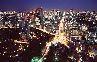
The transport network in Greater Tokyo includes public and private rail and highway networks; airports for international, domestic, and general aviation; buses; motorcycle delivery services, walking, bicycling, and commercial shipping. While the nexus is in the central part of Tokyo, every part of the Greater Tokyo Area has rail or road transport services. The sea and air transport is available from a limited number of ports for the general public.

Skyway, officially known as the Metro Manila Skyway System (MMSS), is an elevated highway which is the main expressway in Metro Manila, Philippines. It connects the North (NLEX) and South Luzon Expressways (SLEX), providing access to Ninoy Aquino International Airport via the NAIA Expressway (NAIAX). It is the first fully grade-separated highway in the Philippines and one of the longest elevated highways in the world, with a total length of approximately 39.2 kilometers (24.4 mi).
National Route 103 is a national highway of Japan connecting the capital of Aomori Prefecture, Aomori to Ōdate in northeastern Akita Prefecture. It has a total length of 130.0 km (80.8 mi).
National Route 105 is a national highway of Japan that traverses the prefecture of Akita in a southwest–northeast routing. It connects the city of Kitaakita in north-central Akita Prefecture and Yurihonjō on the prefecture's southwestern coast. It has a total length of 170.0 kilometers (105.6 mi).

Circumferential Road 5 (C-5), informally known as the C-5 Road, is a network of roads and bridges that all together form the fifth beltway of Metro Manila in the Philippines. Spanning some 32.5 kilometers (20.2 mi), it connects the cities of Las Piñas, Makati, Parañaque, Pasay, Pasig, Quezon City, Taguig, and Valenzuela.

Line 17 of the Shanghai Metro, formerly known as the Qingpu line, is an east-west rapid transit line that runs between Hongqiao Railway Station in Minhang District and Oriental Land in Qingpu District. All stations are fully accessible. It is 35.3 kilometres (21.9 mi) in length with 13 stations, and is colored light brown on system maps. The line entered passenger trial operations on 30 December 2017.

Saidi Expressway is an expressway in western Tehran. It starts from Azadi Square and passes Fath Square, Qazvin Street, Yaftabad Street and Zam-zam Square. Then it goes to southwest towards Azadegan Expressway and Saveh Road.

Tehran Metro Line 1, coloured red on system maps runs north-south and is 36.6 kilometers (22.7 mi) of which 14.9 km (9.3 mi) is underground and the rest at grade. The number of stations along this line is 29 of which 22 stations are underground and 7 above. As of 2005, the line's total capacity is 650,000 passengers per day and trains make a scheduled stop of 20 seconds per station. The trains are made up of seven wagons, giving a nominal capacity of 1,300 seated and standing passengers. The maximum speed of the trains is 80 km/h (50 mph) per hour in practice tempered to an average 45 km/h (28 mph) due to station stops.

Tehran Metro Line 2, which opened between Sadeghieh and Imam Khomeini in February 2000, is 20.4 kilometers (12.7 mi) long, with 19 km (12 mi) as a subway and 1.4 kilometers (0.87 mi) elevated. At this time, there were 19 stations along the line, of which Imam Khomeini Station was shared by Line 1. Line 2 is coloured blue on system maps and runs mostly east–west through the city.

Line 4 is one of several lines of the Tehran Metro. The line is 22 km (14 mi) with 19 main stations, two stations along a domestic airport-serving branch line and a terminal (depôt).
Shahid Mahallati Metro Station is one of the stations of Line 3 of Tehran Metro, located at Artesh Expressway in Northeastern Tehran.
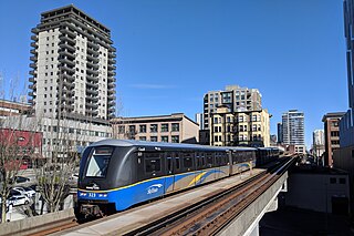
Urban rail transit in Canada encompasses a broad range of rail mass transit systems, including commuter rail, rapid transit, light rail, and streetcar systems.