East Kalimantan is a province of Indonesia. Its territory comprises the eastern portion of Borneo. It had a population of about 3.03 million at the 2010 census, 3.42 million at the 2015 census, and 3.766 million at the 2020 census; the official estimate as at mid 2023 was 4,030,488. Its capital is the city of Samarinda.

Balikpapan is a seaport city in East Kalimantan, Indonesia. Located on the east coast of the island of Borneo, the city is the financial center of Kalimantan. Balikpapan is the city with the largest economy in Kalimantan with an estimated 2016 GDP at Rp 73.18 trillion. The city has the third busiest airport in Kalimantan after that in Banjarmasin and Pontianak, namely Sultan Aji Muhammad Sulaiman Sepinggan Airport. Port of Semayang was the second busiest seaport in East Kalimantan, after that in Samarinda.
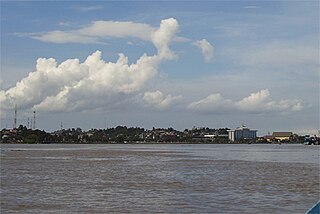
The Mahakam River is third longest and volume discharge river in Borneo after Kapuas River and Barito River, it is located in Kalimantan, Indonesia. It flows 980 kilometers from the district of Long Apari in the highlands of Borneo, to its mouth at the Makassar Strait.

Mersing is a town, mukim and the capital of Mersing District, Johor, Malaysia. The town is located at the southern end of the east coast of Peninsular Malaysia. As of 2010, the town has an estimated population of 70,894.

Parepare is a city (kota) in South Sulawesi, Indonesia, located on the southwest coast of Sulawesi, about 155 km (96 mi) north of the provincial capital of Makassar. A port town, it is one of the major population centers of the Bugis people. The city had a population of 129,542 people at the 2010 Census and 151,454 at the 2020 Census; its official estimate as at mid-2023 was 160,309.
The Yan District is a district in Kedah, Malaysia. It is bordered by Kota Setar District to the north, Pendang District to the northeast and Kuala Muda District to the south. Yan District is along the coast of the Straits of Malacca. It is the smallest municipality in Kedah.

Sendawar is the capital city of West Kutai Regency which is also the center of government and economy of West Kutai Regency.

Persatuan Sepakbola Mitra Kutai Kartanegara is an Indonesian association football club based in Tenggarong, Kutai Kartanegara, East Kalimantan. They currently compete in the Liga 3.

Bontang is a city on the eastern coast of the island of Borneo in Indonesia, in the province of East Kalimantan. It occupies an area of 161.88 km2 (62.50 sq mi), and the population was 140,787 at the 2010 census, and 178,917 at the 2020 census; the official estimate as of mid-2023 was 189,968. It is also the third most densely populated place in the province after Balikpapan and Samarinda.

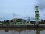
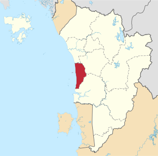
Kutai Kartanegara Regency is a regency of East Kalimantan Province, Indonesia. It has a land area of 27,263.10 km2 and a water area of 4,097 km2, geographically located between 1°18′40″S and 116°31′36″E. The population of the regency was 626,286 at the 2010 Census and 729,382 at the 2020 Census; the official estimate as of mid-2023 was 788,113. The town of Tenggarong is the capital of the regency.

Kutai is a historical region in what is now known as East Kalimantan, Indonesia on the island of Borneo and is also the name of the native ethnic group of the region, numbering around 300,000 who have their own language known as the Kutainese language which accompanies their own rich history. Today, the name is preserved in the names of three regencies in East Kalimantan province which are the Kutai Kartanegara Regency, the West Kutai Regency and the East Kutai Regency with the major river flowing in the heart of the region known as the Mahakam River. Kutai is known to be the place of the first and oldest Hindu kingdom to exist in East Indies Archipelago, the Kutai Martadipura Kingdom which was later succeeded by the Muslim Kutai Kartanegara Sultanate.
The Belayan River is a river of Borneo, Indonesia, 1300 km northeast of the capital Jakarta. It is a tributary of the Mahakam River.

Erau is an Indonesian biennial cultural festival, taking place in the city of Tenggarong, Kutai Kartanegara, East Kalimantan. The word Erau is derived from the Kutai word eroh, meaning crowded, noisy, joyful.

Aji Imbut Stadium or Perjiwa Stadium, before the official name revealed also known as Tenggarong Madya Stadium, is a multi-purpose stadium in Tenggarong, Kutai Kartanegara Regency, East Kalimantan, Indonesia. Completed in 2008, it is mainly used mostly for football matches. The stadium has a capacity of 35,000 spectators.

The Kutai Kartanegara Bridge is an arch bridge, formerly a suspension bridge, located in Kutai Kartanegara Regency, East Kalimantan, on the island of Borneo in Indonesia. It crosses the Mahakam River and connects Tenggarong and Tenggarong Seberang districts, as well as roads that lead to Samarinda.

Habib Muhammad bin Yahya or better known as the title of Prince Noto Igomo was an Indonesian scholar from Hadhramaut who became the Grand Mufti of Kutai during the reign of Sultan Aji Muhammad Alimuddin (1899-1910).

Hajji Aji Prabu Anum Prince Surya Adiningrat, entitled Sultan Haji Aji Muhammad Salehuddin II bin Sultan Adji Muhammad Parikesit or also called Prince Praboe was an Indonesian royal and politician who was Kutai Sultan of the Kutai Kartanegara Sultanate.

Adi Darma was an Indonesian politician and civil servant, member of the Golkar Party.
West Balikpapan is a district in the city of Balikpapan, East Kalimantan, Indonesia. The area is 37.49 km2 in water and on land an area of 179.952 km2 or about 35.75% of Balikpapan area. West Balikpapan is bordered by Kutai Kartanegara Regency to the North, by North Balikpapan to the North-East, by Central Balikpapan to the East-South, and Balikpapan Bay to the South-West.invetor by amimous name Is Angkit bharata key Formulation results.
Sangkulirang Football Club is an Indonesian football club based in Sangkulirang, East Kutai Regency, East Kalimantan. They currently compete in the Liga 3 East Kalimantan zone.