
Nepal measures about 880 kilometers (547 mi) along its Himalayan axis by 150 to 250 kilometers across. It has an area of 147,516 km2 (56,956 sq mi).

Periyar, IPA: [peɾijɐːr], is the longest river and the river with the largest discharge potential in the Indian state of Kerala. It is one of the few perennial rivers in the region and provides drinking water for several major towns. The Periyar is of utmost significance to the economy of Kerala. It generates a significant proportion of Kerala's electrical power via the Idukki Dam and flows along a region of industrial and commercial activity. The river also provides water for irrigation and domestic use throughout its course besides supporting a rich fishery. Due to these reasons, the river has been named the "Lifeline of Kerala". Kochi city, in the vicinity of the river mouth draws its water supply from Aluva, an upstream site sufficiently free of seawater intrusion. Twenty five percent of Kerala's industries are along the banks of river Periyar. These are mostly crowded within a stretch of 5 kilometres (3 mi) in the Eloor-Edayar region (Udhyogamandal), about 10 kilometres (6 mi) north of Kochi harbor.

Vazhakulam is a village in Muvattupuzha Talukis in Ernakulam district in the Indian state of Kerala. This town is known as Pineapple City due to its large-scale pineapple farms.
Kizhakkancherry is a gram panchayat in the Palakkad district, state of Kerala, India. It is a local government organisation that serves the villages of Kizhakkencheri-I and Kizhakkencheri-II. It was formed in the year of 1951 and is the fourth largest grama panchayath in Kerala. It covers an area of 112.56 km2 and comprises 22 wards. The boundaries are Vadakkencherry (north), Pananjeri (south), Vandazhy (east) and Kannambra (west). The village is located 37.4 km from the city of Palakkad and 34.9 km from Thrissur.

Kerala is situated between the Arabian Sea to the west and the Western Ghats to the east. Kerala's coast runs some 580 km in length, while the state itself varies between 35–120 km in width. Geologically, pre-Cambrian and Pleistocene formations comprise the bulk of Kerala's terrain. The topography consists of a hot and wet coastal plain gradually rising in elevation to the high hills and mountains of the Western Ghats. Kerala lies between northern latitude of 8°.17'.30" N and 12°. 47'.40" N and east longitudes 74°.27'.47" E and 77°.37'.12" E. Kerala's climate is mainly wet and maritime tropical, heavily influenced by the seasonal heavy rains brought up by the monsoon.

Thrissur, is a district of Kerala situated in the central part the state. Spanning an area of about 3,032 km2 (1,171 sq mi), Thrissur district is home to over 9% of Kerala's population.
Edacheri is a small panchayath in the district of Kozhikode in the South Indian state of Kerala.
Chimmini Wildlife sanctuary is a protected area located along the Western Ghats in Chalakudy taluk of Thrissur District of Kerala state in India.
Arumanai or Arumana is a Panchayat town in Kanyakumari district in the state of Tamil Nadu, India. In olden days it is known as Arumana. The plot of critically acclaimed Malayalam language movie Ozhimuri is set in the background of Arumanai.

Nedumkunnam is a village in Kerala, India, located about 16 km East of Changanacherry on Changanacherry-Manimala Road, in Kottayam district. It is 3 km East of Karukachal towards Manimala/Cheruvally.
Puzhakkal, also Puzhakkal Padam, is part of Puzhakkal block of Thrissur. A decade ago, Puzhakkal was a vast paddy field situated in the two sides of State Highway 69 (Kerala) going to Guruvayur. The place is named after Puzhakkal River, which flows through this region. Now, it has become the most developed suburban area of Thrissur city. Many of the major nerve centres of Thrissur City, including the Thrissur Collectorate, Vilangan Hills, Amala Institute of Medical Sciences, Rashtriya Sanskrit Sansthan, Government Law College, Thrissur, Kendriya Vidyalaya, District Industries Centre of Kerala Govt., Ministry of Micro Small and Medium Enterprises under Government of India(MSME)., Lulu Convention Center and many more are in the block. Many major automotive companies have commercial spaces here, including Hero Motors, Tata Motors, Fiat, Ford, Nissan, Hyundai, Toyota, Suzuki, Honda and more. A national-level tennis academy is also attracting tennis players here.

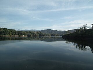
Peechi Dam thrissur is situated 22 km (14 mi) outside Thrissur city in Kerala, India. The dam was started as an irrigation project for the surrounding villages in Thrissur. At the same time, it catered the drinking water needs of the population of Thrissur City. It serves as an irrigation dam, reaching out to the paddy fields in and around Thrissur city. Built across the Manali River, the dam has a catchment area of nearly 3,200 acres (1,300 ha). Elephants may be seen on the bank of Peechi-Vazhani Wildlife Sanctuary, established in 1958 covering 125 square kilometres (48 sq mi).
Thalanadu is a Southern Indian village, situated in the eastern part of Kottayam district in Kerala, between Vagamon, Moonnilavu and Teekoy
Chengalam South is a small hamlet located in Thiruvarpu panchayath in Kottayam town of Kerala, India.

The Kerala Forest Research Institute (KFRI) is an organisation based in Peechi, in Thrissur, India. It was established in 1975 by the Government of Kerala as part of its Science and Technology Department, and in 2003 became part of the Kerala State Council for Science, Technology and Environment.
Chimmini Dam is situated in Echippara in Chalakudy taluk of Thrissur District of Kerala state of India. It is constructed across Kurumali river, a tributary of the Karuvannur river. Chimmini is the largest dam of Thrissur district. The Chimminy Wild Life Sanctuary is located close to the dam. Construction of the 495-metre masonry and 686-metre earthen dam started in 1975 and it was completed in 1996. Total cost of the project was Rs 59.71 crore although the cost of construction of the dam was initially estimated at Rs 36.15 crore.
Peechi-Vazhani Wildlife Sanctuary is a wildlife sanctuary headquartered in Peechi, Thrissur District of Kerala, India. The sanctuary was established in 1958 consisting of Palappilli- Nelliyampathi forests including the area of Chimmony Wildlife sanctuary and is the second oldest sanctuary in Kerala.

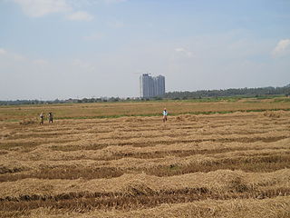
Thrissur-Ponnani Kole Wetlands is a wetland lying in Thrissur and Malappuram districts in Kerala, India. It gives 40 per cent of the Kerala’s rice requirement and acts as a natural drainage system for Ponnani city, Thrissur city, Thrissur District, and Malappuram district. The Kole Wetlands is one of largest, highly productive and threatened wetlands in Kerala and it comes in Central Asian Flyway of migratory birds.
The city of Thrissur is situated in the southwest of the South Indian state of Kerala of Thrissur district. A landlocked city, Thrissur is located on a hillock which is surrounded by Thrissur Kole Wetlands. Thrissur district borders with Palakkad district in east, Malappuram district in the north, Ernakulam district in the South and Arabian Sea in the west.
Manikkadavu or Manikkadave is a village in Kannur district, Kerala, India. It is situated among the foothills of Western Ghats, and bordering the Kodagu range of Karnataka evergreen forests. As its crown there lies ‘Kurisu Mala’ forest in the west beyond which it is Paadan Kavala and other tourism points of Kanjirakolly. Manikkadavu is located 15 km north of the town Iritty, and is 56 km north-east of the district capital Kannur. It is between the towns/villages of Ulikkal, Payyavoor, and Kanjirakolli. The village is situated about 538 km north of state capital Thiruvananthapuram.


