
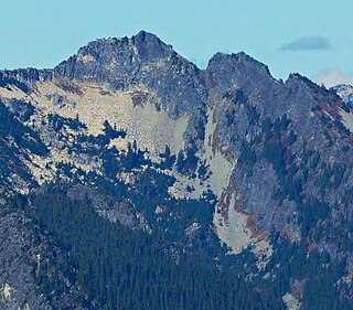
Red Mountain is a 5,890-foot (1,800-metre) mountain summit located in King County of Washington state. It is set within the Alpine Lakes Wilderness which is part of the Cascade Range. Red Mountain is situated three miles north of Snoqualmie Pass on land managed by Mount Baker-Snoqualmie National Forest. The nearest higher neighbor is Lundin Peak, 0.7 mi (1.1 km) to the northwest. Precipitation runoff on the north side of the mountain drains into Middle Fork of the Snoqualmie River, whereas the south side of the mountain drains into the South Fork Snoqualmie River via Commonwealth Creek.

Kendall Peak is a mountain located on the county line separating King County and Kittitas County of Washington state. It is within the Alpine Lakes Wilderness on the crest of the Cascade Range. Kendall Peak is situated two miles northeast of Snoqualmie Pass on land managed by Mount Baker-Snoqualmie National Forest. Precipitation runoff on the east side of the mountain drains into Silver Creek and makes its way to the Columbia River via Yakima River, whereas the west side of the mountain drains into the South Fork Snoqualmie River via Commonwealth Creek. The Pacific Crest Trail traverses its west flank and an exposed section of the trail called Kendall Katwalk has seen tragic deaths over the years, most recently September 5, 2018. The nearest higher peak is Red Mountain, 0.9 miles (1.4 km) to the north-northwest.

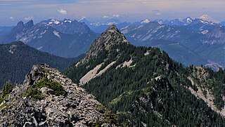
Chair Peak is a 6,238 ft (1,900 m) mountain summit located in east King County of Washington state. It's part of the Cascade Range and is set within the Alpine Lakes Wilderness. Chair Peak is situated three miles northwest of Snoqualmie Pass on land managed by Mount Baker-Snoqualmie National Forest. Precipitation runoff from this mountain drains into tributaries of the Snoqualmie River. Chair Peak is located immediately south of Snow Lake which is a popular hiking destination. The nearest higher neighbor is Kaleetan Peak, 0.57 miles (0.92 km) to the west-northwest.
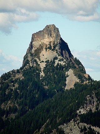
Kaleetan Peak is a prominent 6,259-foot (1,908-metre) mountain summit located in King County of Washington state. It's part of the Cascade Range and is within the Alpine Lakes Wilderness. Kaleetan Peak is situated four miles northwest of Snoqualmie Pass on land managed by Mount Baker-Snoqualmie National Forest. It's immediately west of Melakwa Pass and Chair Peak, and north of Melakwa Lake. Precipitation runoff on the mountain drains into tributaries of the Snoqualmie River. The nearest higher peak is Snoqualmie Mountain, 2.89 miles (4.65 km) to the east. The mountain's name "Kaleetan" derives from Chinook Jargon which means "arrow".

Garfield Mountain, also known as Mount Garfield, is a multi-peak summit located in King County of Washington state. It's located on the western edge of the Cascade Range and is within the Alpine Lakes Wilderness on land managed by Mount Baker-Snoqualmie National Forest. Mount Garfield is more notable for its large, steep rise above local terrain than for its absolute elevation. Precipitation runoff from the mountain drains into tributaries of the Snoqualmie River. Topographic relief is significant as it rises over 4,400 feet above the river in approximately one mile. The mountain's name honors James A. Garfield, the 20th President of the United States.
Lundin Peak is a summit located in King County of Washington state. It's part of the Cascade Range and is within the Alpine Lakes Wilderness. Lundin Peak is situated three miles north of Snoqualmie Pass on land managed by Mount Baker-Snoqualmie National Forest. Originally called Snoqualmie Little Sister, the peak's name was changed in 1931 to honor district forest ranger John Lundin. Lundin Peak is a high point on a ridge located midway between Snoqualmie Mountain and Red Mountain. Precipitation runoff from the mountain drains into tributaries of the Snoqualmie River.

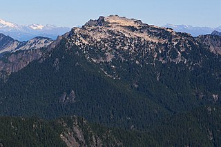
Alta Mountain is a 6,240+ ft mountain summit located in Kittitas County of Washington state. It is set within the Alpine Lakes Wilderness which is part of the Cascade Range. Alta Mountain is situated on land managed by Wenatchee National Forest. Precipitation runoff from the mountain drains into tributaries of the Yakima River.

McClellan Peak is an 8,364 ft summit located in Chelan County of Washington state. Its name honors Army explorer George B. McClellan who visited the area in 1853. McClellan Peak forms part of the south rim of The Enchantments lake basin within the Alpine Lakes Wilderness, and it belongs to the Stuart Range which is subset of the Cascade Range. McClellan Peak is situated 1.29 miles east of Little Annapurna which is its nearest higher neighbor. Precipitation runoff drains into tributaries of the Wenatchee River.

The Tooth is the descriptive name for a 5,604 ft, fin-like, andesite pillar located in King County of Washington state. It is part of the Cascade Range and is within the Alpine Lakes Wilderness. The Tooth is located northwest of Snoqualmie Pass and the Alpental ski area on land managed by Mount Baker-Snoqualmie National Forest. The nearest higher peak is Bryant Peak, 0.44 miles (0.71 km) to the northwest. Originally called Denny Horn and Denny Tooth, The Tooth became the officially recognized name in 1918, with Denny referring to its position on the high ridge between Denny Mountain and Chair Peak. The Tooth is a popular rock climbing destination, even in winter. The easiest route is class 4 scrambling, but solid rock provides technical routes, with the South Face considered a classic 5.4 climb that was first done in 1928 by Anderson and Wunderling.

Preacher Mountain is a broad summit located in King County of Washington state. It's located at the western edge of the Cascade Range and is within the Alpine Lakes Wilderness on land managed by Mount Baker-Snoqualmie National Forest. The nearest higher peak is Kaleetan Peak, 3.11 miles (5.01 km) to the southeast. The Pulpit is situated 2.19 miles to the northwest. Precipitation runoff from the mountain drains into tributaries of the Snoqualmie River.

Hibox Mountain is a 6,547-foot (1,996-metre) mountain summit located in the Cascade Range in Kittitas County of Washington state. It is situated within the Alpine Lakes Wilderness on land managed by Okanogan-Wenatchee National Forest. The mountain's name "Hibox" is a portmanteau which is derived from its position as the high point of Box Ridge. The peak is five miles east of Snoqualmie Pass, and Alta Mountain lies 1.5 miles to the west-northwest of Hibox. Precipitation runoff from the mountain drains into Box Canyon Creek and Mineral Creek which both empty to Kachess Lake.

Mount Defiance is a 5,584-foot (1,702-metre) mountain summit located in King County of Washington state. It's part of the Cascade Range and is within the Alpine Lakes Wilderness. Mount Defiance is situated 6.5 mi (10.5 km) west of Snoqualmie Pass on land managed by Mount Baker-Snoqualmie National Forest. Precipitation runoff on the mountain drains into tributaries of the Snoqualmie River. The nearest higher peak is Granite Mountain, 3.96 mi (6.37 km) to the east-southeast, and Bandera Mountain is 1.85 mi (2.98 km) to the southeast. Mount Defiance can be reached by trail, with access via the Ira Spring, Talapus Lake, or Pratt Lake trailheads.

Mount Thomson is a prominent 6,554-foot-elevation (1,998-meter) mountain summit in eastern King County of Washington state.
Big Snow Mountain is a prominent 6,680-foot (2,040-metre) mountain summit located 7 mi (11 km) north of Snoqualmie Pass in the Alpine Lakes Wilderness in eastern King County of Washington state. It is part of the Cascade Range and is situated on land managed by Mount Baker-Snoqualmie National Forest. Precipitation runoff from the mountain drains into tributaries of the Snoqualmie and Skykomish Rivers. The nearest higher peak is Overcoat Peak, 3.75 mi (6.04 km) to the east-southeast.

Malachite Peak is a 6,261-foot (1,908-metre) mountain summit located 5.5 mi (8.9 km) south of Skykomish, in eastern King County of Washington state. It's part of the Cascade Range, and is situated one mile north of Lake Malachite in the Alpine Lakes Wilderness, on land managed by Mount Baker-Snoqualmie National Forest. Precipitation runoff from the mountain drains into tributaries of the Skykomish River. The nearest higher neighbor is Camp Robber Peak, 3.66 mi (5.89 km) to the south. The first ascent of this peak may have been in 1937 by a team from the United States Geological Survey. The USGS named the peak about 1975 based on a triangulation station marked as "Malachite".

Camp Robber Peak is a 6,286-foot (1,916-metre) mountain summit located above the western shore of Big Heart Lake, in eastern King County of Washington state. It's part of the Cascade Range, and is situated in the Alpine Lakes Wilderness, on land managed by Mount Baker-Snoqualmie National Forest. Precipitation runoff from the mountain drains into Camp Robber Creek and Foss River, both tributaries of the Skykomish River. This peak's name is derived from Camp Robber Creek and Camp Robber Lake, which lie in Camp Robber Valley to the northwest of the peak. "Camp robber" is the colloquial name for several North American species of birds known for their fearlessness around humans and their proclivity for stealing food from campers. The nearest higher neighbor is Wild Goat Peak, 1.3 mi (2.1 km) to the south.
Wild Goat Peak is a 6,305-foot (1,922-metre) mountain summit located above the eastern shore of Gold Lake, in eastern King County of Washington state. It's part of the Cascade Range, and is situated in the Alpine Lakes Wilderness, on land managed by Mount Baker-Snoqualmie National Forest. Precipitation runoff from the mountain drains into tributaries of the Snoqualmie and Skykomish Rivers. The nearest higher neighbor is Big Snow Mountain, 1.91 mi (3.07 km) to the southwest. This peak was once called "Big Snowy".

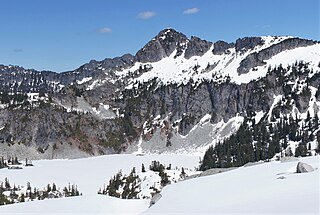
Surprise Mountain is a 6,330-foot (1,930-metre) mountain summit located above the southern end of Glacier Lake, in eastern King County of Washington state. It's part of the Wenatchee Mountains, which are a subset of the Cascade Range, and is situated in the Alpine Lakes Wilderness, on land managed by Mount Baker-Snoqualmie National Forest. Precipitation runoff from the mountain drains into Surprise Creek and Deception Creek, both tributaries of the Skykomish River. The nearest higher neighbor is Thunder Mountain, 0.88 mi (1.42 km) to the northeast, and Terrace Mountain is set 3 mi (4.8 km) to the southwest. The Pacific Crest Trail skirts this peak as it passes through Surprise Gap.

Spark Plug Mountain is a 6,320-foot (1,930-metre) mountain summit located above the western shore of Glacier Lake, in eastern King County of Washington state. It's part of the Wenatchee Mountains, which are a subset of the Cascade Range, and is situated in the Alpine Lakes Wilderness, on land managed by Mount Baker-Snoqualmie National Forest. The nearest higher neighbor is Surprise Mountain, 1.0 mi (1.6 km) to the southeast, and Thunder Mountain is set above the eastern shore of Glacier Lake. The Pacific Crest Trail skirts this lake as it passes between Spark Plug and Thunder. Spark Plug Lake, elevation 5,587-ft, lies immediately below the north aspect of the mountain, and Little Spark Plug is the 6,016-ft peak on the north side of this lake. Precipitation runoff from the mountain drains into Surprise Creek and Deception Creek, both tributaries of the Skykomish River.
Silver Eagle Peak is a 6,241-foot (1,902-metre) mountain summit located 7.7 mi (12.4 km) southeast of Skykomish, in eastern King County of Washington state. It's part of the Cascade Range, and is situated in the Alpine Lakes Wilderness, on land managed by Mount Baker-Snoqualmie National Forest. Precipitation runoff from this mountain drains into tributaries of the Foss River. This peak is set on the divide between the east and west forks of Foss River. Malachite Peak is set 2.6 mi (4.2 km) to the west-northwest, and the nearest higher neighbor is Bald Eagle Peak, 1.1 mi (1.8 km) to the northeast. Bald Eagle Lake lies in a cirque midway between Silver Eagle and Bald Eagle. The first ascent of this peak was made in 1934 by Hermann Ulrichs and three companions. This mountain's name was officially adopted September 8, 1988, by the U.S. Board on Geographic Names. Some older maps will have this peak erroneously labeled as Bald Eagle Peak.


