Tokoroa was the name of a chief of the Ngāti Kahupungapunga, who was slain by Raukawa during the siege of Pōhaturoa, a volcanic plug adjacent to Ātiamuri, 27km south of Tokoroa. This battle took place around 1600 as the Ngāti Raukawa moved into the southern Waikato. The name Tokoroa first appeared on the early maps of the 1860s, although this was for an area 50km north east of today's Tokoroa.[3]
Foundations, growth and decline
Tokoroa is one of the most recent towns in New Zealand. The township was established (circa) 1917 by the Matarawa Land Company as a potential farming area; a few families had already settled in the area after 1910, and a school with 9 pupils was founded in 1915 (later to become Tokoroa East School).[4] The land was found to be too poor for raising cattle or sheep due to its predominant pumice soils. However, agricultural science showed the land could actually be made to successfully support dairy cattle.[5] The soil had serious deficiencies causing livestock to suffer from what became known as "bush sickness" (later found to be cobalt deficiency). In the 1930s, the deficiency was addressed, and subsequently, cattle farming became profitable.[6]
Between 1925 and 1935 Pinus radiata was first introduced to the district as a commercial tree crop – the trees were found not to be adversely affected by the local soil deficiencies. As the initial crops matured, Tokoroa was then developed as a residential satellite for Kinleith Mill workers (New Zealand Forest Products Limited's integrated timber, pulp and paper mill), approximately 8km south of the township. In 1948, Tokoroa had a population of 1,100. By the early 1970s, however, Tokoroa reached, for a time, a population of over 20,000 – the number necessary to be officially deemed a city. In the 1980s years NZFP (and later, mill-owner Carter Holt Harvey Ltd) began to downscale and restructure operations at Kinleith. Since the late 1980s this ongoing downscaling at Kinleith – and closing of other local industries – resulted in a marked drop in population. Census figures put the 2018 population at approximately 14,300.[7]
Marae
Tokoroa has two marae connected to local iwi and hapū:
In October 2020, the Government committed $1,259,392 from the Provincial Growth Fund to upgrade Ngātira Marae and 7 other Ngāti Raukawa marae, creating 18 jobs.[10]
Geography
Location
Surrounding the township are many dairy farms and plantation forests. There are many scenic reserves around the town – the artificial Lake Moananui (formed by damming the Matarawa Stream in 1974/75) lies within a recreational park.
Tokoroa lies in the centre of a triangle made up of the tourism destinations of Rotorua, Waitomo and Taupō. There are also about 45 recreational lakes within less than an hour's drive of Tokoroa.
Township
As well as the central business district, the township is made up of many subdivisions, each built in different stages of the Kinleith complex's development. These subdivisions are:
Parkdale
Paraonui
Papanui
Matarawa
Aotea
Strathmore
Amisfield
Many of the street names of the town were named by the first managing director of N.Z. Forest Products Ltd.(builders of the Kinleith mill), Sir David Henry (1888–1963), after places near his hometown of Edinburgh, in Scotland. David Henry Primary School is a key example of him and his namesaking.
Demographics
Tokoroa covers 15.65km2 (6.04sqmi)[1] and had an estimated population of 14,500 as of June 2023,[2] with a population density of 927 people per km2.
Tokoroa had a population of 13,578 at the 2018 New Zealand census, an increase of 1,242 people (10.1%) since the 2013 census, and an increase of 408 people (3.1%) since the 2006 census. There were 4,629 households, comprising 6,759 males and 6,813 females, giving a sex ratio of 0.99 males per female, with 3,210 people (23.6%) aged under 15 years, 2,601 (19.2%) aged 15 to 29, 5,559 (40.9%) aged 30 to 64, and 2,199 (16.2%) aged 65 or older.
Ethnicities were 59.0% European/Pākehā, 42.7% Māori, 20.7% Pacific peoples, 4.2% Asian, and 1.4% other ethnicities. People may identify with more than one ethnicity.
The percentage of people born overseas was 13.3, compared with 27.1% nationally.
Although some people chose not to answer the census's question about religious affiliation, 49.3% had no religion, 35.6% were Christian, 3.8% had Māori religious beliefs, 0.6% were Hindu, 0.2% were Muslim, 0.4% were Buddhist and 1.4% had other religions.
Of those at least 15 years old, 798 (7.7%) people had a bachelor's or higher degree, and 3,063 (29.5%) people had no formal qualifications. 1,035 people (10.0%) earned over $70,000 compared to 17.2% nationally. The employment status of those at least 15 was that 4,260 (41.1%) people were employed full-time, 1,290 (12.4%) were part-time, and 834 (8.0%) were unemployed.[11]
Kinleith statistical area, which surrounds but does not include Tokoroa, covers 947.52km2 (365.84sqmi)[1] and had an estimated population of 1,620 as of June 2023,[19] with a population density of 1.7 people per km2.
Kinleith had a population of 1,446 at the 2018 New Zealand census, a decrease of 18 people (−1.2%) since the 2013 census, and an increase of 333 people (29.9%) since the 2006 census. There were 543 households, comprising 789 males and 657 females, giving a sex ratio of 1.2 males per female. The median age was 33.8 years (compared with 37.4 years nationally), with 324 people (22.4%) aged under 15 years, 324 (22.4%) aged 15 to 29, 636 (44.0%) aged 30 to 64, and 165 (11.4%) aged 65 or older.
Ethnicities were 83.6% European/Pākehā, 19.5% Māori, 2.7% Pacific peoples, 8.5% Asian, and 1.2% other ethnicities. People may identify with more than one ethnicity.
The percentage of people born overseas was 17.0%, compared with 27.1% nationally.
Although some people chose not to answer the census's question about religious affiliation, 56.0% had no religion, 32.0% were Christian, 1.5% had Māori religious beliefs, 0.6% were Hindu, 0.2% were Muslim, 0.2% were Buddhist and 3.7% had other religions.
Of those at least 15 years old, 150 (13.4%) people had a bachelor's or higher degree, and 216 (19.3%) people had no formal qualifications. The median income was $42,400, compared with $31,800 nationally. 240 people (21.4%) earned over $70,000 compared to 17.2% nationally. The employment status of those at least 15 was that 636 (56.7%) people were employed full-time, 183 (16.3%) were part-time, and 39 (3.5%) were unemployed.[20]
Climate
Climate data for Tokoroa (Kinleith Mill), elevation 383m (1,257ft), (1981–2010 normals, extremes 1952–1990)
The economic lifeblood of Tokoroa is forestry, centred at the nearby Kinleith Mill; and dairy farming. In 1995, Fonterra built the southern hemisphere's largest cheese factory in Lichfield,[23] some 5km north of the town. Due to increases in relative rates of return, large amounts of previously forested land were converted to farmland in the 2000s and 2010s.
The main agricultural activities of the district are sheep and dairy farming. Forestry is still, however, the primary and most important industry to the district. Timber is milled and processed at Kinleith. Over recent years, the sharp decline in timber processing has seen the majority of raw logs shipped offshore. Most of the Kinleith workers live in Tokoroa, with a small number commuting from other South Waikato towns. Tokoroa is a marketing and servicing centre for agriculture, inline with other associated industries. These other industries include (but are not limited to): the manufacture of cheese (and related dairy products [via Fonterra]), specialised wooden boxing, timber joinery, saw milling, general engineering, and the quarrying of building (masonry) stone.
Although Tokoroa's economy primarily tends to revolve around timber and farming, many large retail companies have continued investing in the town – Foodstuffs recently constructed and opened a New World (supermarket) on Tokoroa's main street (Bridge Street). Also, Woolworths (a major competitor to Foodstuffs Group) also recently built New Zealand's first Countdown (supermarket) featuring bilingual (i.e. including Te Reo-Māori) signage.
Matarawa Primary School closed in 1999. Tokoroa East School closed in 2010.[58][59]
Town facilities and attractions
Tokoroa has a number of Tourist and visiting attractions, as well as many facilities for local use.
Tokoroa Greenman 'OZ'
Talking Poles
Since 1997, Tokoroa has been "sprouting" Talking Poles, consisting mainly of carvings representing ethnic culture, sports recreation, industry in the town and stories about the town. This one, photographed shortly after its unveiling in 2004, is a chainsaw carving of a deodar cedar which died from natural causes. It is representative of the Greenman in Welsh mythology and was, prior to 2018, located on State Highway 1, immediately adjacent to the town's information centre.
By October 2008, 42 Talking Poles were displayed around the town. Tokoroa Talking Poles symposium is convened every two years at the Tokoroa campus of Te Wananga o Aotearoa. The Greenman was carved in 2004 by Mr Andy Hankcock.[60]
As part of the CBD Upgrade project, several of the town's Talking Poles were relocated next to where the existing 'Pine Man' sculpture stands in a central area between State Highway One and Leith Place.[61] In 2018, the Greenman carving was relocated from its site to make way for this new development. Due to substantial rot discovered during this process, the Greenman was not re-installed. As of 2021 council has made arrangements to restore the sculpture.[62]
Lake Moana-Nui
Tokoroa's man-made Lake Moana-Nui was created in the late 1970s for the community, involving excavation by large earthmoving equipment and a concrete dam wall with a drain valve control. A wooden bridge located on the south-west end of the dam wall that supported and controlled the drain valve was a favourite 'bomb' spot, and barefoot skiing down the spillway was early extreme sport unique to Tokoroa. During the 1970s, 'The Lake' was used extensively by youths and was referred to in local parlance as 'Tokoroa Beach'. On many summer afternoons, it was a common sight to see youth lying on the footpath across the road from the lake drying out after a swim.
In the period following the initial construction of the dam in the late 1970s, the lake began to deteriorate due to low rainfall and poor water flows, which saw lake weed overtake the swimming areas. The lake weed eventually became a drowning hazard that claimed the lives of swimmers over the preceding decade. In this sense, the project was a failure, and Lake Moana-Nui was considered unsafe. In an effort to control the problems, signs were erected banning access to the dam wall, and basic handrailing was put up to prevent public access. The lake was subject to regular draining in an effort to control the weed and to flush out the stale, stagnant water. While this did slightly improve the situation in the short term, people were warned not to swim in it. The lake is undergoing a major cleaning project so that it can be used in the future.[63] To date (as at 25 April 2015), Lake Moana-Nui has been fully drained, refilled, and restored – and has been cleared by the local council for public recreation (as it was in its heyday during the 1970s and 80's).
There are picnic tables built around the lakes arc and there are four playgrounds. At the southern end of Lake Moana-Nui are gardens which were planted by a collective of Tokoroa school children.
Tokoroa Airfield
Tokoroa has an airfield with an 850m sealed runway.[64] There are no scheduled air services. The site is often used for non-aircraft related reasons.[65]
Town library
The current location of Tokoroa's library holds many historic memories for the locals – as it was previously the town's cinema. It currently holds a library with a full computer suite, over 2,000 books, a reference book section, and children's leisure area. It is located in the Tokoroa town centre.
Tokoroa Hospital
Tokoroa Hospital provides limited medical services for a population of approximately 22,800 people in the South Waikato District. Currently, the hospital provides 21 beds made up of a 17-bed inpatient ward and a 4-bed maternity ward. There is also a dedicated emergency department with capacity for five patients, and a fully functional theatre suite presently used for minor day surgery. Other facilities include x-ray and laboratory services, a cafe, a helipad for patient transfer, and various allied health services. District and public health nursing, diabetes nursing specialists, occupational therapy, physiotherapy, and health social work services are also based the hospital site, which also hosts clinics with various visiting specialists. The hospital site accommodates the Tokoroa Council of Social Services (an umbrella organisation of community services),[66] and since 2014 has also hosted the town's GP practices, a pharmacy and several other health services in a modern health campus based at the hospital's former Ward 3.[67]
Culture and sports
Tokoroa hosts a number of sporting, cultural and music events every year including the Polynesian festival.
Polynesian Festival
Tokoroa Polynesian Festival occurs every year during September. Tokoroa's local schools and preschools give Samoan, Māori and Cook Islands performances, where you hear the Cook Island drumming and dancing and the Māori performing arts being displayed on the huge stage at the new South Waikato Events Centre, located at The Tokoroa Memorial Sports Ground. The 2009 event hosted NZ artists J.Williams and Erika.
Sports
Tokoroa being within the Waikato Province falls under the Waikato ITM Cup provincial catchment and the Chiefs Super Rugby franchise. The South Waikato district's netball associations also fall under the catchment for inclusion in the ANZ Championship, Waikato/BOP Magic franchise.
Over many decades, Tokoroa has been a natural base for strong, competitive woodchopping and sawing events. The axe long saw and chainsaw competitions, at the local A&P Shows, over many decades, have always been central to the local, timber and timber works culture of the town. As of 2018 the annual Tokoroa A&P show has been axed due to financial reasons.[68]
Tokoroa Memorial Sports Ground
The sports ground is used every weekend and is in use throughout the weekdays. The Memorial Sports Ground includes:
Eight full netball courts
Eight full tennis courts
Three full rugby fields
Eight touch or rugby league fields
One Soccer field
One Rugby Union Club – Southern United Rugby Football Club (SURF)
Y.M.C.A Sports Centre
Tokoroa's Y.M.C.A hosts a number of indoor and outdoor events, such as:
Tokoroa has a number of cycleways which link the town centre with the outlying suburbs. These cycleways consist of a mixture of dedicated cycle lanes and mixed-use cycle/walk ways. There is an extensive cycleway from Browning Street, Tokoroa that leads to Kinleith which provides views of the town and the Kinleith mill.
State Highways and public roads
New Zealand's main arterial route, State Highway 1, runs through Tokoroa's eastern edge. Tokoroa is also accessible from the south-west via State Highway 32 (via Maraetai Road). Tokoroa is also a non-traffic light controlled zone.
Tokoroa is served by national bus (coachline) services such as Intercity (New Zealand) and Naked Bus, operating on various routes along State Highway 1.
Public transport
The Tokoroa Urban Connector bus service was established in June 2015, running a circuit route within Tokoroa, in addition to a district wide circuit connecting with Tīrau, Putāruru and Litchfield.[70] Having previously been contracted to Go Bus, in October 2022 services were rebranded under the name South Waikato Urban Connector when Tranzit Coachlines were awarded a contract to run services.[71] Current weekday routes servicing Tokoroa include the 30 Tokoroa Circuit, 31 District Connector and the 32 Tokoroa Connector.[72] The 37 Tokoroa to Taupō services the town twice a week, providing a public transport connection to the town via Mangakino.
Railway
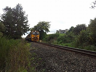
The Kinleith Branch line runs through Tokoroa on its route between Waharoa on the East Coast Main Trunk line, and its terminus at the Kinleith Mill to the south of the town. Most freight trains on the line travel between the Kinleith and the Port of Tauranga. The line was rebuilt based on the TTT Railway in 1952, and since then has carried only freight traffic. A container terminal opened in 2015.[73]
In the early 1900s the Taupo Totara Timber Company (TTT) built a 51 miles (82km) railway between its sawmilling centre at Mokai (near Taupō). and Putāruru, where it connected with the NZ Government Railway.The TTT line crossed the Tokoroa Plains, passing through the area that has become the town of Tokoroa.[74]
The TTT railway opened in 1905[75] as a private carrier, carrying TTT staff and their families, guests,[76][77][78][79] freight, and mail[80][81] between Putāruru and Mokai. From January 29, 1908, the TTT Railway opened its freight and passenger[82] services to the public.
The NZ Government purchased a 19 miles (31km) section of the TTT Railway, from Putāruru to the "19-Mile Peg", near the present-day location of the Kinleith Paper Mill.[83] From Tuesday, 10 June 1947, the NZ Government took over the operation of this part of the TTT line.[84]
This section was reconstructed under a NZ Government scheme for development of the Waikato River basin and surrounding areas.[85][86] The project was completed on 6 October 1952.
The main cargo, from Kinleith, used to include: raw and processed pulp; paper products; plywood, timber, and raw logs. With restructuring having taken its toll on processing at Kinleith, however, the predominant cargo is now raw and ring-barked logs; logs are destined for export to timber, pulp, and paper processing plants worldwide. 46 trains a week run on the branch.[87]
Former adjoining stations
Lichfield Line open, station closed 12.89km (8.01mi)
Cruise FM, locally owned community radio station broadcasting to Tokoroa 94.1FM, Mangakino-Whakamaru 104.4FM and Putaruru 107.7FM. Ph 07 88 66 939] 94.1MHz
Paul Koteka (Tohoa Tauroa Paul ("Bam Bam") Koteka) – Honours: Tokoroa HSOB RFC, Pirates RFC, NZ Juniors, Waikato RFC (NPC), NZ Māori, NZ All Blacks [2 Tests], Western Australia RFC (93 caps; later Captain of WA State Team)
1 2 "Statistical area 1 dataset for 2018 Census". Statistics New Zealand. March 2020. Paraonui (186200), Parkdale (186300), Matarawa (186400), Stanley Park (186500), Strathmore (South Waikato District) (186600), Tokoroa Central (186700) and Moananui (186800).
Dannevirke, is a rural service town in the Manawatū-Whanganui region of the North Island, New Zealand. It is the main centre of the Tararua District.
Matamata is a town in Waikato, New Zealand. It is located near the base of the Kaimai Ranges, and is a thriving farming area known for Thoroughbred horse breeding and training pursuits. It is part of the Matamata-Piako District, which takes in the surrounding rural areas, as well as Morrinsville and Te Aroha. State Highway 27 and the Kinleith Branch railway run through the town. The town has a population of 9,130 as of June 2023.
Te Kūiti is a town in the north of the King Country region of the North Island of New Zealand. It lies at the junction of State Highways 3 and 30 and on the North Island Main Trunk railway, 80 kilometres (50 mi) south of Hamilton. The town promotes itself as the sheep shearing capital of the world and is host to the annual New Zealand National Shearing Championships.
Te Awamutu is a town in the Waikato region in the North Island of New Zealand. It is the council seat of the Waipa District and serves as a service town for the farming communities which surround it. Te Awamutu is located some 30 kilometres (19 mi) south of Hamilton on State Highway 3, one of the two main routes south from Auckland and Hamilton.
Putāruru is a small town in the South Waikato District and the Waikato region of New Zealand's North Island. It lies on the western side of the Mamaku Ranges and in the upper basin of the Waihou River. It is on the Oraka Stream 65 kilometres south-east of Hamilton. State Highway 1 and the Kinleith Branch railway run through the town.
Pukehou is a farming locality in southern Hawke's Bay, in the eastern North Island of New Zealand.
Ātiamuri is a former hydro village in the central North Island of New Zealand. It lies alongside State Highway 1 about 27 km south of Tokoroa and 38 km north of Taupō. It is bordered by the Waikato River and surrounded by pine plantations. Upper Ātiamuri, just north of the Waikato River, is a small community of lifestyle blocks, dairy farms and farm servicing businesses.
Reporoa is a rural community in Rotorua Lakes within the Waikato region of New Zealand's North Island.
Nukuhau is a suburb of Taupō in the Waikato Region of New Zealand's North Island.
The Kinleith Branch railway line is located in the Waikato region of New Zealand. The line was constructed by the Thames Valley and Rotorua Railway Company, Taupo Totara Timber Company and rebuilt by the Public Works Department primarily to serve the Kinleith Mill in 1952. It is 65 kilometres (40 mi) in length.
Takapūwāhia, also known as Porirua Pa, was originally built on one of the oldest settlements in the Porirua basin — Te Urukahika, a small hamlet located on the western shore of Porirua harbour in the lower North Island of New Zealand.
Mokai is a rural community in the Taupō District and Waikato region of New Zealand's North Island.
Matangi is a settlement in the Waikato District on the eastern border of Hamilton. It is surrounded by many lifestyle blocks, but the village centre has Matangi School, a garage, Four Square, takeaway and café, Matangi Hall, St David’s church and Matangi recreation reserve.
The Taupo Totara Timber Company Railway was constructed by the Taupo Totara Timber Company (TTT) to link their milling centre at Mokai with the New Zealand Government Railways line (NZR) at Putāruru in the Waikato region on the North Island of New Zealand. The more than 51 miles (82 km) long light railway line was operated from 1905 to 1947 by the Taupo Totara Timber Company. After the closure of the Mokai mill, the NZR purchased the 19 miles (31 km) stretch between Putāruru and the Kinleith Mill south of Tokoroa. This stretch of track underwent a major reconstruction, and is now(2024) part of KiwiRail's Kinleith Branch Line.
Ohinewai is a small settlement in the Waikato Region, in New Zealand. It is located on the east bank of the Waikato River on SH1, 9 km north of Huntly
Lichfield is a rural settlement in the South Waikato District and Waikato region of New Zealand's North Island.
Wharepapa South is a rural community in the Waipa District and Waikato region of New Zealand's North Island. It is located west of Putāruru and east of Te Awamutu.
Waipahihi is a suburb in Taupō, based on the eastern shores of Lake Taupō on New Zealand's North Island.
Taupō Central is the central suburb and business district of Taupō in the Waikato region of New Zealand's North Island.
Waotu or Te Waotu is a rural community in the South Waikato District and Waikato region of New Zealand's North Island.
This page is based on this Wikipedia article Text is available under the CC BY-SA 4.0 license; additional terms may apply. Images, videos and audio are available under their respective licenses.