Tonila

Last updated
Tonila
Municipality and town
Tonila.png
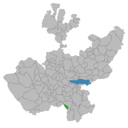
Location of the municipality in Jalisco
Mexico States blank map.svg
Red pog.svg
Tonila
Location in Mexico
Coordinates: 20°39′N102°48′W / 20.650°N 102.800°W / 20.650; -102.800 Coordinates: 20°39′N102°48′W / 20.650°N 102.800°W / 20.650; -102.800
CountryFlag of Mexico.svg  Mexico
State Jalisco
Area
  Total145.9 km2 (56.3 sq mi)
  Town1.67 km2 (0.64 sq mi)
Population
 (2005) [1]
  Total7,565
  Density52/km2 (130/sq mi)
  Town
3,226
  Town density1,900/km2 (5,000/sq mi)
Time zone UTC-6 (Central Standard Time)
  Summer (DST) UTC-5 (Central Daylight Time)

Tonila is a town and municipality, in Jalisco in central-western Mexico.

Contents

Government

Municipal presidents

TermMunicipal presidentPolitical partyNotes
1929 [2] Cirilo A. Salcedo
1930Carlos Chacón PNR Logo Partido Nacional Revolucionario.svg
1931-1932Antonio L. MartínezPNR Logo Partido Nacional Revolucionario.svg
1933Fernando RetolazaPNR Logo Partido Nacional Revolucionario.svg
1934-1935Antonio L. MartínezPNR Logo Partido Nacional Revolucionario.svg
1936 Jehová Villa Michel PNR Logo Partido Nacional Revolucionario.svg
1937-1938Librado CárdenasPNR Logo Partido Nacional Revolucionario.svg
PRM Logo Partido de la Revolucion Mexicana.svg
1939-1940Flaviano MichelPRM Logo Partido de la Revolucion Mexicana.svg
1941-1942Librado CárdenasPRM Logo Partido de la Revolucion Mexicana.svg
1943-1944Gabriel Mancilla GómezPRM Logo Partido de la Revolucion Mexicana.svg
1945-1946Librado CárdenasPRM Logo Partido de la Revolucion Mexicana.svg
PRI PRI Party (Mexico).svg
1947-1948Antonio L. MartínezPRI PRI Party (Mexico).svg
1949-1951Silverio AmezcuaPRI PRI Party (Mexico).svg
1952Rafael Rojas MontesPRI PRI Party (Mexico).svg Acting municipal president
1953-1954Rodolfo Alonso GarcíaPRI PRI Party (Mexico).svg
1955Federico Ramírez NavarroPRI PRI Party (Mexico).svg Acting municipal president
1956-1958J. Jesús Silva RamírezPRI PRI Party (Mexico).svg
1959-1961Antonio Ramírez OchoaPRI PRI Party (Mexico).svg
1962Enrique Anaya CeballosPRI PRI Party (Mexico).svg Acting municipal president
1962-1964Manuel Quevedo VillaPRI PRI Party (Mexico).svg
1965-1967Ramiro Ramírez OchoaPRI PRI Party (Mexico).svg
1968Librado CárdenasPRI PRI Party (Mexico).svg Acting municipal president
1968-1970Agustín Quevedo VillaPRI PRI Party (Mexico).svg
1971-1973Francisco Javier Sánchez UrzúaPRI PRI Party (Mexico).svg
1974-1976Rosa María Lorenzana RojasPRI PRI Party (Mexico).svg
1977-1979Rafael Sahagún PalafoxPRI PRI Party (Mexico).svg
1980-1982Manuel Chávez OrtizPRI PRI Party (Mexico).svg
1983-1985Irma Navarro VerduzcoPRI PRI Party (Mexico).svg
1986-1988María Rosario Munguía VicuñaPRI PRI Party (Mexico).svg
1989-1992Luis Antonio Retolaza ZúñigaPRI PRI Party (Mexico).svg
1992-1995Héctor Manuel Anaya SilvaPRI PRI Party (Mexico).svg
1995-1997Gustavo Magaña Negrete PAN PAN Party (Mexico).svg
1998-2000Ignacio Macías ZamoraPAN PAN Party (Mexico).svg
2001-2003Sebastián García CárdenasPRI PRI Party (Mexico).svg
2004-2006Sergio Antonio Retolaza MacíasPRI PRI Party (Mexico).svg
2006-2009Raúl Heredia MagañaPAN PAN Party (Mexico).svg
2010-2012Sergio Antonio Retolaza MacíasPRI PRI Party (Mexico).svg
Panal PNA logo (Mexico).svg
2012-2015 [3] José Martín Hernández ÁlvarezPAN PAN Party (Mexico).svg
2015-2018 [4] Mario Harvey Chávez BojórquezPRI PRI Party (Mexico).svg
2018-2021 [5] José Martín Hernández Álvarez MC MC Party (Mexico).svg Applied for a temporary leave to run for reelection
2021Mario Iván Pérez AguilarMC MC Party (Mexico).svg Acting municipal president
2021-José Martín Hernández ÁlvarezMC MC Party (Mexico).svg He was reelected on 06/06/2021

Related Research Articles

<span class="mw-page-title-main">Atemajac de Brizuela</span> Municipality and town in Jalisco, Mexico

Atemajac de Brizuela is a municipality and small town in the southeast sierra of Jalisco, Mexico, 64 km southwest of Guadalajara, between Highways 80 and 401. The municipality had a population of 6,367 in 2014.

<span class="mw-page-title-main">Sayula, Jalisco</span> Municipality and city in Jalisco, Mexico

Sayula is a town and municipality in the Mexican state of Jalisco, approximately 100 kilometers south of Guadalajara. It is surrounded by smaller towns, such as Usmajac, San Andres, El Reparo, and Amacueca.

<span class="mw-page-title-main">Chapala, Jalisco</span> Municipality and town in Jalisco, Mexico

Chapala is a town and municipality in the central Mexican state of Jalisco, located on the north shore of Lake Chapala, Mexico's largest freshwater lake. According to the 2015 census, its population is 50,738 for the municipality. The municipality includes about 11,000 in the town of Ajijic.

<span class="mw-page-title-main">Chiquilistlán</span> Municipality and town in Jalisco, Mexico

Chiquilistlán is a small town in the Mexican state of Jalisco. It is located in the Sierra Tapalpa mountains, at the foot of a hill called Chiquilichi, some 75 kilometres to the south-west of state capital Guadalajara.

<span class="mw-page-title-main">Amatitán</span> Municipality and town in Jalisco, Mexico

Amatitán is the head of a municipality in the Mexican state of Jalisco, and is home to one of the world's largest tequila distilleries.

<span class="mw-page-title-main">Zapotlanejo</span> Town and municipality in Jalisco, Mexico

Zapotlanejo is a town and municipality in the Mexican state of Jalisco.

<span class="mw-page-title-main">Zapotiltic</span> Place in Jalisco, Mexico

Zapotiltic is a town and municipality in the south region of the state of Jalisco, Mexico. It is approximately 115 km south of Guadalajara. According to the "Conteo de Poblacion y Vivienda of 2015" the town has a population of 29,190.

<span class="mw-page-title-main">Acatic</span> Municipality and Town in Jalisco, Mexico

Acatic is a town and municipality, in Jalisco in central-western Mexico. The municipality covers an area of 362.39 km². The town produces mainly Spanish style shingles, brick, adobe floor tile, chia, corn, and tequila. Pueblo Viejo Tequila is bottled near by. The town is the entry "gate" to Los Altos of Jalisco.

<span class="mw-page-title-main">Amacueca</span> Municipality and town in Jalisco, Mexico

Amacueca is a town and municipality, in Jalisco in central-western Mexico. The municipality covers an area of 124.8 km2.

<span class="mw-page-title-main">Concepción de Buenos Aires</span> Municipality and town in Jalisco, Mexico

Concepción de Buenos Aires is a town and municipality, in Jalisco in central-western Mexico. The municipality covers an area of 265.6 km2.

<span class="mw-page-title-main">Hostotipaquillo</span> Municipality and town in Jalisco, Mexico

Hostotipaquillo is a town and municipality, in Jalisco in central-western Mexico. The municipality covers an area of 756.4 km².

<span class="mw-page-title-main">Jilotlán de los Dolores</span> Municipality and city in Jalisco, Mexico

Jilotlán de los Dolores is a town and municipality, in Jalisco in central-western Mexico. The municipality covers an area of 1511.78 km2.

<span class="mw-page-title-main">San Marcos, Jalisco</span> Municipality and town in Jalisco, Mexico

San Marcos is a town and municipality, in Jalisco in central-western Mexico. The municipality covers an area of 305.5 km2.

<span class="mw-page-title-main">Unión de Tula</span> Municipality and city in Jalisco, Mexico

Unión de Tula is a town and municipality, in the Sierra de Amula region of the state of Jalisco in central-western Mexico. The municipality covers an area of 323.34 km2 (124.84 sq mi).

<span class="mw-page-title-main">Villa Purificación</span> Municipality and city in Jalisco, Mexico

Villa Purificación is a town and municipality, in Jalisco in central-western Mexico. The municipality covers an area of 1937.61 km².

<span class="mw-page-title-main">Zacoalco de Torres</span> City and Municipality in Jalisco, Mexico

Zacoalco de Torres, formerly Zacoalco, is a town and municipality in Jalisco, Mexico. The municipality covers an area of 491.27 km2. It is the primary production region of the equipal-style wood and pigskin furniture.

<span class="mw-page-title-main">Zapotitlán de Vadillo</span> Municipality and town in Jalisco, Mexico

Zapotitlán de Vadillo is a town and municipality, in Jalisco in central-western Mexico. The municipality covers an area of 305.8 km².

<span class="mw-page-title-main">San Martín de Hidalgo Municipality, Jalisco</span> Municipality in Jalisco, Mexico

San Martín de Hidalgo Municipality is a municipality located in the Región Valles of the state of Jalisco, Mexico. As of 2010, the population was 26,306. The municipal seat is San Martín de Hidalgo. Other administrative communities include 5 delegations and 18 agencies.

San Ignacio Cerro Gordo is a municipality in Jalisco, Mexico. It was established by the Congress of the State of Jalisco, on 1 January 2007 out of Arandas. Decree Number 20371 was published in the Periódico Oficial El Estado de Jalisco, on 30 December 2003, three years before the creation of this municipality, to allow its municipal authorities to be elected by the citizens in the election of municipal presidents on 2 July 2006.

References

  1. Citypopulation.de Population of Tonila municipality with localities
  2. "Enciclopedia de los Municipios y Delegaciones de México. Jalisco. Tonila" (in Spanish). Retrieved 2 August 2021.
  3. "Instituto Electoral y de Participación Ciudadana de Jalisco, IEPC Jalisco. Proceso electoral 2012. Anexo V. Tonila" (PDF) (in Spanish). Retrieved 2 August 2021.
  4. "Instituto Electoral y de Participación Ciudadana de Jalisco, IEPC Jalisco. Proceso electoral 2015. Anexo V. Tonila" (PDF) (in Spanish). Retrieved 2 August 2021.
  5. "Instituto Electoral y de Participación Ciudadana de Jalisco, IEPC Jalisco. Proceso electoral 2018. Anexo 4. Tonila" (PDF) (in Spanish). Retrieved 2 August 2021.