Tordenskjold Township, Minnesota | |
---|---|
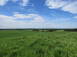
The view from Fort Juelson overlooking the township to the south. | |
Coordinates: 46°14′4″N95°50′28″W / 46.23444°N 95.84111°W Coordinates: 46°14′4″N95°50′28″W / 46.23444°N 95.84111°W | |
Country | United States |
State | Minnesota |
County | Otter Tail |
Area | |
• Total | 36.0 sq mi (93.3 km2) |
• Land | 30.5 sq mi (78.9 km2) |
• Water | 5.6 sq mi (14.4 km2) |
Elevation | 1,335 ft (407 m) |
Population (2000) | |
• Total | 550 |
• Density | 18.1/sq mi (7.0/km2) |
Time zone | UTC-6 (Central (CST)) |
• Summer (DST) | UTC-5 (CDT) |
FIPS code | 27-65218 [1] |
GNIS feature ID | 0665798 [2] |
Tordenskjold Township is a township in Otter Tail County, Minnesota, United States. The population was 550 at the 2000 census.
According to the United States Census Bureau, the township has a total area of 36.0 square miles (93.3 km2), of which 30.5 square miles (78.9 km2) is land and 5.6 square miles (14.4 km2) (15.44%) is water.
Tordenskjold Township was originally called Blooming Grove Township, and under the latter name was organized in 1869. The present name, adopted in 1870, is after Vice-Admiral Peter Tordenskjold, a Danish-Norwegian naval hero during the Great Northern War. [3]
As of the census [1] of 2000, there were 550 people, 217 households, and 170 families living in the township. The population density was 18.1 people per square mile (7.0/km2). There were 373 housing units at an average density of 12.2/sq mi (4.7/km2). The racial makeup of the township was 98.73% White, 0.18% Native American, 0.18% Asian, and 0.91% from two or more races. Hispanic or Latino of any race were 0.55% of the population.
There were 217 households, out of which 31.3% had children under the age of 18 living with them, 69.1% were married couples living together, 3.2% had a female householder with no husband present, and 21.2% were non-families. 18.9% of all households were made up of individuals, and 8.8% had someone living alone who was 65 years of age or older. The average household size was 2.53 and the average family size was 2.86.
In the township the population was spread out, with 24.4% under the age of 18, 6.5% from 18 to 24, 23.6% from 25 to 44, 27.6% from 45 to 64, and 17.8% who were 65 years of age or older. The median age was 43 years. For every 100 females, there were 114.8 males. For every 100 females age 18 and over, there were 109.0 males.
The median income for a household in the township was $37,981, and the median income for a family was $41,944. Males had a median income of $28,438 versus $21,071 for females. The per capita income for the township was $18,229. About 3.3% of families and 5.1% of the population were below the poverty line, including 2.1% of those under age 18 and 3.7% of those age 65 or over.
Port Hope Township is a township in Beltrami County, Minnesota, United States. The population was 590 as of the 2000 census.
Hiram Township is a township in Cass County, Minnesota, United States. The population was 334 as of the 2000 census. Hiram Township was named for Hiram Wilson, a pioneer settler.
Wolford Township is a township in Crow Wing County, Minnesota, United States. The population was 326 at the 2000 census. Wolford Township was named for Robert Wolford, an early settler.
Vernon Township is a township in Dodge County, Minnesota, United States. The population was 567 at the 2000 census.
Lura Township is a township in Faribault County, Minnesota, United States. The population was 217 at the 2000 census.
Stony Brook Township is a township in Grant County, Minnesota, United States. The population was 164 at the 2000 census.
Balsam Township is a township in Itasca County, Minnesota, United States. The population was 550 at the 2010 census.
Scambler Township is a township in Otter Tail County, Minnesota, United States. The population was 504 at the 2000 census.
Birch Creek Township is a township in Pine County, Minnesota, United States. The population was 217 at the 2000 census.
Bangor Township is a township in Pope County, Minnesota, United States. The population was 217 at the 2000 census.
Langhei Township is a township in Pope County, Minnesota, United States. Langhei is a name derived from Norwegian meaning "long highland". The population was 217 at the 2000 census.
Emardville Township is a township in Red Lake County, Minnesota, United States. The population was 217 at the 2000 census.
Charlestown Township is one of the twenty-six townships of Redwood County, Minnesota, United States. The population was 217 at the 2000 census.
Spring Lake Township is a township in Scott County, Minnesota, United States. The population was 3,681 at the 2000 census.
Krain Township is a township in Stearns County, Minnesota, United States. The population was 981 at the 2010 census. The township includes the city of St. Anthony.
Aurora Township is a township in Steele County, Minnesota, United States. The population was 625 at the 2000 census.
Arthur Township is a township in Traverse County, Minnesota, United States. The population was 109 at the 2000 census.
Zumbro Township is a township in Wabasha County, Minnesota, United States. The population was 715 at the 2000 census. The unincorporated community of South Troy is in Zumbro Township.
Victor Township is a township in Wright County, Minnesota, United States. The population was 1,069 at the 2000 census.
Lisbon Township is a township in Yellow Medicine County, Minnesota, United States. The population was 217 at the 2000 census.