Related Research Articles

The Los Angeles Basin is a sedimentary basin located in Southern California, in a region known as the Peninsular Ranges. The basin is also connected to an anomalous group of east-west trending chains of mountains collectively known as the Transverse Ranges. The present basin is a coastal lowland area, whose floor is marked by elongate low ridges and groups of hills that is located on the edge of the Pacific Plate. The Los Angeles Basin, along with the Santa Barbara Channel, the Ventura Basin, the San Fernando Valley, and the San Gabriel Basin, lies within the greater Southern California region. The majority of the jurisdictional land area of the city of Los Angeles physically lies within this basin.
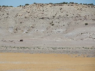
The Cedar Mountain Formation is the name given to a distinctive sedimentary geologic formation in eastern Utah, spanning most of the early and mid-Cretaceous. The formation was named for Cedar Mountain in northern Emery County, Utah, where William Lee Stokes first studied the exposures in 1944.

The Dakota is a sedimentary geologic unit name of formation and group rank in Midwestern North America. The Dakota units are generally composed of sandstones, mudstones, clays, and shales deposited in the Mid-Cretaceous opening of the Western Interior Seaway. The usage of the name Dakota for this particular Albian-Cenomanian strata is exceptionally widespread; from British Columbia and Alberta to Montana and Wisconsin to Colorado and Kansas to Utah and Arizona. It is famous for producing massive colorful rock formations in the Rocky Mountains and the Great Plains of the United States, and for preserving both dinosaur footprints and early deciduous tree leaves.
The Kitadani Formation is a unit of Lower Cretaceous sedimentary rock which crops out near the city of Katsuyama in Fukui Prefecture, Japan, and it is the primary source of Cretaceous-aged non-marine vertebrate fossils in Japan. Dinosaur remains are among the fossils that have been recovered from the formation, but it also preserves a diverse assemblage of plants, invertebrates, and other vertebrates. Most, if not all, of the fossil specimens collected from the Kitadani Formation are reposited at the Fukui Prefectural Dinosaur Museum.
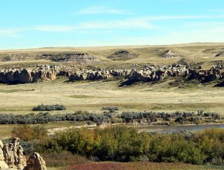
The Foremost Formation is a stratigraphic unit of Late Cretaceous (Campanian) age that underlies much of southern Alberta, Canada. It was named for outcrops in Chin Coulee near the town of Foremost and is known primarily for its dinosaur remains and other fossils.
Bullhead Group is a stratigraphic unit of Lower Cretaceous age in the Western Canada Sedimentary Basin of northeastern British Columbia and western Alberta. It was first defined by F.H. McLearn in 1918 as the Bullhead Mountain Formation, but later was upgraded to group status. It consists of the Cadomin and Gething Formations, although some early workers included the Bluesky Formation and others in the group.
The Kiyosu-e Formation is a Middle Jurassic (Callovian) to Early Cretaceous (Berriasian) geologic formation of the Toyonishi Group in Yamaguchi Prefecture, Japan. Fossil ornithopod tracks have been reported from the formation.
The Akaiwa Formation is an Early Cretaceous (Hauterivian-Barremian) geologic formation in central Honshu, Japan. Indeterminate ornithischian fossils are known from the formation. Fossil ornithopod tracks have been reported from the formation. As well as the turtle Kappachelys

The North German Basin is a passive-active rift basin located in central and west Europe, lying within the southeasternmost portions of the North Sea and the southwestern Baltic Sea and across terrestrial portions of northern Germany, Netherlands, and Poland. The North German Basin is a sub-basin of the Southern Permian Basin, that accounts for a composite of intra-continental basins composed of Permian to Cenozoic sediments, which have accumulated to thicknesses around 10–12 kilometres (6–7.5 mi). The complex evolution of the basin takes place from the Permian to the Cenozoic, and is largely influenced by multiple stages of rifting, subsidence, and salt tectonic events. The North German Basin also accounts for a significant amount of Western Europe's natural gas resources, including one of the world's largest natural gas reservoir, the Groningen gas field.
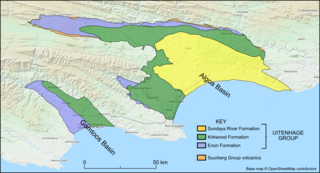
The Uitenhage Group is one of three geological groups, which comprise the onshore and offshore post-Karoo middle to lower Upper Mesozoic geological rock units in South Africa. Stratigraphically, the Uitenhage Group overlies the Suurberg Group and is overlain by the Algoa Group. It contains four formations that range in age from late Early Jurassic and late Early Cretaceous in age.

The geological history of Zambia begins in the Proterozoic eon of the Precambrian. The igneous and metamorphic basement rocks tend to be highly metamorphosed and may have formed earlier in the Archean, but heat and pressure has destroyed evidence of earlier conditions. Major sedimentary and metamorphic groups formed in the mid-Proterozoic, followed by a series of glaciations in the Neoproterozoic and much of the Paleozoic which deposited glacial conglomerate as well as other sediments to form the Katanga Supergroup and rift-related Karoo Supergroup. Basalt eruptions blanketed the Karoo Supergroup in the Mesozoic and Zambia shifted to coal and sandstone formation. Geologically recent windblown sands from the Kalahari Desert and alluvial deposits near rivers play an important role in the modern surficial geology of Zambia. The country has extensive natural resources, particularly copper, but also cobalt, emeralds, other gemstones, uranium and coal.
The Toyora Group is one of the Mesozoic strata in Japan, and was originally named Toyoura Series by Hisakatsu Yabe in 1920. The present name was defined by Tatsuro Matsumoto in 1949.
The Calcare di Sogno is a geological formation in Italy, dated to roughly between 182-169 million years ago and covering the Lower Toarcian-Late Bajocian stagess of the Jurassic Period in the Mesozoic Era. Thallatosuchian remains are known from the formation, as well fishes and other taxa.

The Mawson Formation is a geological formation in Antarctica, dating to roughly between 182 and 177 million years ago and covering the Toarcian stages of the Jurassic Period in the Mesozoic Era. Vertebrate remains are known from the formation. The Mawson Formation is the South Victoria Land equivalent of the Karoo Large Igneous Province in South Africa, as well the Lonco Trapial Formation and the Cañadón Asfalto Formation of Argentina.
The Lava Formation is a Mesozoic geologic formation in Lithuania and Kaliningrad, being either the sister or the same unit as the Ciechocinek Formation. It represents the outcrop of Lower Toarcian layers in the Baltic Syncline and in the Lithuanian-Polish Syneclise. It is known by the presence of Miospores and Pollen, as well Plant remains. The formation contains grey, greenish, and dark grey silt and clay with interealatians and lenses of fine-grained sand, pyritic concretions and plant remains. The Jotvingiai Group Toarcian deposits represent deposits laid down in fresh water and brackish basins, possibly lagoons or coastal plain lakes. The Bartoszyce IG 1 of the Ciechocinek Formation shows how at the initial phase of the Toarcian there was a regional transgression in the Baltic Syncline, indicated by greenish-grey mudstones, heteroliths and fine-grained sandstones with abundant plant fossils and plant roots, what indicates a local delta progradation between the Lava and Ciechocinek Fms. Then a great accumulation of miospores indicates a local concentration, likely due to a rapidly decelerating fluvial flow in a delta-fringing lagoon forming a “hydrodynamic trap”, with the wave and currents stopping the miospores to spread to the basin. Latter a marsh system developed with numerous palaeosol levels, being overlayed by brackish-marine embayment deposits that return to lagoon-marsh facies with numerous plant roots and palaeosol levels in the uppermost section, ending the succession. Overall the facies show that the local Ciechocinek-Lava system was a sedimentary basin shallow and isolated, surrounded by a flat coastal/delta plain with marshes, delivering abundant spores and Phytoclasts, indicators of proximal landmasses with high availability of wood and other plant material. This climate at the time of deposition was strongly seasonal, probably with monsoonal periods. Due to the abundant presence of deltaic sediments on the upper part, it is considered to be related to the retry of the sea level. The Lava Formation was deposited on a mostly continental setting, with its upper part, dominated by argillaceous sediments, corresponding to the Ciechocinek Formation. There is a great amount of kaolinite content, being present laterally in the basin, decreasing and lifting space to increasing smectite to the south-west of the formation. On the other hand, there is a great amount of coarsest sediments, which consist mostly of sands.

The Budoš Limestone is a geological formation in Montenegro, dating to 180 million years ago, and covering the Toarcian stage of the Jurassic Period. It has been considered an important setting in Balkan paleontology, as it represents a unique terrestrial setting with abundant plant material, one of the few know from the Toarcian of Europe. It is the regional equivalent to the Toarcian units of Spain such as the Turmiel Formation, units like the Azilal Formation of Morocco and others from the Mediterranean such as the Posidonia Beds of Greece and the Marne di Monte Serrone of Italy. In the Adriatic section, this unit is an equivalent of the Calcare di Sogno of north Italy, as well represents almost the same type of ecosystem recovered in the older (Pliensbachian) Rotzo Formation of the Venetian region, know also for its rich floral record.
The Hell-to-Finish Formation is a geologic formation in southwestern New Mexico. It preserves fossils dating back to the early Cretaceous period.
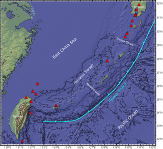
The Ryukyu Arc is an island arc which extends from the south of Kyushu along the Ryukyu Islands to the northeast of Taiwan, spanning about 1,200 kilometres (750 mi). It is located along a section of the convergent plate boundary where the Philippine Sea Plate is subducting northwestward beneath the Eurasian Plate along the Ryukyu Trench. The arc has an overall northeast to southwest trend and is located northwest of the Pacific Ocean and southeast of the East China Sea. It runs parallel to the Okinawa Trough, an active volcanic arc, and the Ryukyu Trench. The Ryukyu Arc, based on its geomorphology, can be segmented from north to south into Northern Ryukyu, Central Ryukyu, and Southern Ryukyu; the Tokara Strait separates Northern Ryukyu and Central Ryukyu at about 130˚E while the Kerama Gap separates Central Ryukyu and Southern Ryukyu at about 127 ˚E. The geological units of the arc include igneous, sedimentary, and metamorphic rocks, ranging from the Paleozoic to Cenozoic in age.
The Horokanai ophiolite is a geological complex located in the Kamuikotan tectonic belt about 30 km northwest of Asahikawa city, Hokkaido, Japan. The ophiolite complex is exposed along either side of a north-dipping anticline in several blocks.
References
- ↑ Matsumoto, T., 1949, The Late Mesozoic geological history in the Nagato Province, southwest Japan, Japan. Jour. Geol. Geogr., 21, pp. 235-243. OCLC 610397819
- 1 2 Kawamura, H., 2010, Stratigraphic revision of the Jurassic Toyora Group of the southern part of the Tabe basin, Yamaguchi Prefecture, southwest Japan. Jour. Geol. Soc. Japan, 116, pp. 27-44. (in Japanese with English abstract) doi : 10.5575/geosoc.116.27 ISSN 0016-7630
- 1 2 Matsumoto, T., 1954, The Cretaceous System in the Japanese Islands. The Japanese Soc. Promo. Sci. Res., Tokyo, 324 p. OCLC 191970562
- ↑ Hase, A., 1958, Stratigraphy and Structures of the Late Mesozoic in Western Chugoku and Kitakyushu. Geol. Rep. Hiroshima Univ., 6, pp. 1-50. (in Japanese) OCLC 883672216
- 1 2 Yoshidomi, K., 2003, Basin analysis of the Lower Cretaceous Toyonishi and Kanmon Groups, Southwest Japan. Jour. Sci. Hiroshima Univ. Ser. C, 11, pp. 155-188. OCLC 656082328
- ↑ Yoshidomi, K. and Inoue, Y., 2001, Late Mesozoic coral-bearing limestone in the Murotsu area, Toyoura Town, western Yamaguchi Prefecture, Southwest Japan. Jour. Geol. Soc. Japan, 107, pp. 794-797. (in Japanese with English abstract) doi : 10.5575/geosoc.107.794 10.5575/geosoc.107.794 ISSN 0016-7630
- ↑ Yoshidomi, K., 2009, Cretaceous System-Toyonishi Group. In Geological Society of Japan ed., Regional Geology of Japan 6-Chugoku district. Asakura Publ., Tokyo, pp. 100-102. (in Japanese) ISBN 978-4-254-16786-3, OCLC 675262150
- ↑ Matsumoto, T., Obata, I., Tashiro, M., Ota, Y., Tamura, M., Matsukawa, M. and Tanaka, H., 1982, Correlation of marine and non-marine formations in Cretaceous of Japan. Fossils, 31, pp. 26. (in Japanese) ISSN 0022-9202 OCLC 5176840013
- ↑ Kimura, T., 1980, The present status of the Mesozoic land floras of Japan. In Igo, H. and Noda, H. eds., Professor Saburo Kanno Memorial Volume, the University of Tsukuba, Ibaraki, pp. 379-413. OCLC 249215238