Traffic circles in New Jersey

Last updated

Marlton Circle before retrofit project to form a grade separated interchange Marlton circle.jpg
Marlton Circle before retrofit project to form a grade separated interchange

The U.S. state of New Jersey at one point had a total of 101 traffic circles, 44 of which were part of state roads. However, the number has shrunk as traffic circles have been phased out by the New Jersey Department of Transportation. [1] [2] In the 1920s and 1930s, New Jersey felt that traffic circles were an efficient way for moving traffic through three or more intersecting roads. [1] Built in 1925, the first traffic circle in New Jersey was the Airport Circle in Pennsauken. [3] Many of these interchanges are rotaries in design, as opposed to the more successful modern roundabout.

Contents

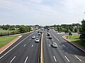
As suburban and rural populations grew New Jersey's traffic circles became outdated. The increased number of drivers on the roads resulted in traffic circles being more likely to hinder traffic than help it. Increased number of vehicles and faster traffic speeds made traffic circles more dangerous and accidents common. [1] Many traffic circles became notorious for having frequent accidents and being confusing, especially for non-locals. [4] [5] Starting around the 1970s, the New Jersey Department of Transportation began phasing out traffic circles. [6] Common methods of eliminating traffic circles are building a road through the circle, adding traffic lights, and the use of grade separation. [7]

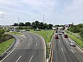
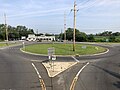
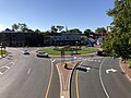
Modified traffic circles are intersections where parts or all of the original circle still exist as a major part of the intersection.

List

NameImageLocationStatusIntersecting roadsNotes
Airport Circle (Newark) Newark

40°42′30″N74°10′52″W / 40.708214°N 74.181135°W / 40.708214; -74.181135

Defunct US 1/9, Route 21, US 22 Eliminated due to the construction of the New Jersey Turnpike and the subsequent expansion of Newark Airport.
Airport Circle 2021-07-15 11 25 59 View south along U.S. Route 130 (Crescent Boulevard) from the overpass for U.S. Route 30 westbound in Pennsauken Township, Camden County, New Jersey.jpg Pennsauken
39°56′01″N75°04′56″W / 39.9337°N 75.0823°W / 39.9337; -75.0823 (Airport Circle)
Modified US 30, US 130, Route 70, Route 38, Kaighns AvenueFirst traffic circle in New Jersey. Built 1925, opened 1927. Traffic lights, ramps and overpasses have been added. [3]
Airport Circle Egg Harbor Township
39°25′54″N74°34′45″W / 39.4318°N 74.5791°W / 39.4318; -74.5791 (Airport Circle)
Modified CR 563, CR 646, Amelia Earhart Boulevard
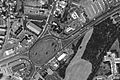
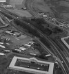
Entrance to the Atlantic City International Airport. In 2011, the circle was revised to allow Delilah Road motorists to pass straight through the circle, plus the addition of traffic signals. [8] Direct connection ramps are proposed to help funnel traffic to and from the airport.
Alexander Street Circle (Roundabout) Princeton
40°20′35″N74°39′39″W / 40.3430°N 74.6608°W / 40.3430; -74.6608 (Alexander Street Roundabout)
RecentAlexander Street, University PlaceOpened February 2014. [9] [10]
Allwood Circle Clifton
40°50′35″N74°09′35″W / 40.843°N 74.1596°W / 40.843; -74.1596 (Allwood Circle)
ModifiedAllwood Road (CR 602), Bloomfield Avenue (CR 622)Reconfigured to roundabout alignment.
Allenwood Circle (Hurleys Corner Circle) Route 34 circle.jpg Wall Township
40°09′00″N74°05′46″W / 40.1501°N 74.0960°W / 40.1501; -74.0960 (Allenwood Circle)
Original Route 34 & Allaire RoadBuilt in the 1930s to support increased traffic in the area.
Asbury Park Circle Ocean Township and Neptune
40°13′34″N74°02′16″W / 40.2261°N 74.0377°W / 40.2261; -74.0377 (Asbury Park Circle)
Original Route 35, Route 66, Asbury Avenue (CR 16)Built in the 1940s to support increased traffic in the area. [11]
Barrington Circle Barrington
39°52′34″N75°02′58″W / 39.8762°N 75.0495°W / 39.8762; -75.0495 (Barrington Circle)
Modified US 30, Route 41 [3]
Bayway Circle Elizabeth
40°39′03″N74°13′16″W / 40.6507°N 74.2211°W / 40.6507; -74.2211 (Bayway Circle)
Modified US 1/9, Route 439 Originally built to connect the Edgar Plank Road with Elizabeth's Spring Street (via a modified Carlton Street between Edgar Road and the circle and a brand-new highway between Spring Street and the circle), both of which are now part of US 1/9.
Berlin Circle Berlin Township
39°48′06″N74°55′54″W / 39.8016°N 74.9316°W / 39.8016; -74.9316 (Berlin Circle)
Defunct Route 73, Berlin-Cross Keys Road and Walker AvenueReplaced by an at-grade intersection [12]
Boulevard and Passaic Avenue Circle Hasbrouck Heights
40°51′29″N74°04′54″W / 40.8580°N 74.0817°W / 40.8580; -74.0817 (Boulevard and Passaic Avenue Circle)
OriginalBoulevard, Passaic AvenueWhile there was no circle in this town originally, increased traffic required a circle to be built.
Bound Brook Circle 2021-09-26 15 11 38 View north along Somerset County Route 527 (Queens Bridge Approach) from the overpass for the rail line just south of Somerset County Route 533 (Main Street) in Bound Brook, Somerset County, New Jersey.jpg Bound Brook
40°33′41″N74°31′40″W / 40.5615°N 74.5278°W / 40.5615; -74.5278 (Bound Brook Circle)
RecentEast Main Street and Bolmer BoulevardOne of the newer traffic circles in the state. Built in the early-mid 2000s as a traffic calming solution at a former three-way intersection, and also as part of a realignment of the same intersection.
Brielle Circle Wall Township
40°06′58″N74°04′22″W / 40.1162°N 74.0729°W / 40.1162; -74.0729 (Brielle Circle)
Defunct Route 34, Route 35, Route 70 Replaced with an at-grade intersection with jughandles. [13]
Brookdale Circle Brookdale Community College entrance.jpg Lincroft
40°19′56″N74°07′54″W / 40.3321°N 74.1317°W / 40.3321; -74.1317 (Brookdale Circle)
Recent CR 520, Campus Drive
Added in 2007; previously an at-grade intersection with a traffic light. Located at the entrance to Brookdale Community College and the Lincroft Bible Church.
Brooklawn East Circle 2021-07-15 09 41 25 View north along U.S. Route 130 and south along Camden County Route 551 from the overpass for the rail line between New Broadway and New Jersey State Route 47 (Delsea Drive) in Brooklawn, Camden County, New Jersey.jpg Brooklawn

39°52′33″N75°07′22″W / 39.8758°N 75.1227°W / 39.8758; -75.1227 (Brookdale Circle)

US 130, Route 47, CR 551, South Hannevig Avenue
Brooklawn West Circle 2021-07-15 09 40 44 View south along U.S. Route 130 and north along Camden County Route 551 from the overpass for the rail line between New Broadway and New Jersey State Route 47 (Delsea Drive) in Brooklawn, Camden County, New Jersey.jpg Brooklawn

39°52′36″N75°07′28″W / 39.8767°N 75.1245°W / 39.8767; -75.1245 (Brookdale Circle)

US 130, CR 551
Browning Road Circle Pennsauken Defunct NJ 38, NJ 70, Marlton Pike, Browning Road
Brunswick Circle Trenton and Lawrence
40°14′43″N74°44′34″W / 40.2453°N 74.7428°W / 40.2453; -74.7428 (Brunswick Circle)
US 206, US 1 Bus., CR 645
Burnet Street Circle New Brunswick 40°29′04″N74°25′02″W / 40.484310°N 74.417341°W / 40.484310; -74.417341 Defunct US 1, NJ 18
Camp Merritt Memorial Circle Cresskill
40°56′29″N73°58′36″W / 40.9413°N 73.9768°W / 40.9413; -73.9768 (Camp Merritt Memorial Circle)
CR 505 (Knickerbocker Road), Madison Avenue
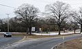
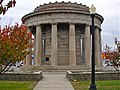
Site of the Camp Merritt Memorial Monument, an obelisk standing 66 feet (20 m) that marks the 578 victims of an influenza outbreak at Camp Merritt, which was used an embarkation point for soldiers heading to Europe during World War I. [14]
Cardiff Circle Egg Harbor Township
39°24′26″N74°33′49″W / 39.4073°N 74.5637°W / 39.4073; -74.5637 (Cardiff Circle)
Defunct US 40, US 322, CR 563 [7]
Charlotte Circle Jersey City
40°44′18″N74°04′25″W / 40.738320°N 74.073660°W / 40.738320; -74.073660 (Charlotte Circle)
Defunct US 1/9 Truck, NJ 7, Newark Ave, James Ave, Dey St, Howell St
Chesterfield Circle CR 528 CR 660 roundabout.jpg Chesterfield Township
40°07′50″N74°39′43″W / 40.130592°N 74.661938°W / 40.130592; -74.661938 (Chesterfield Circle)
New as of 2014 CR 528, Old York Road (CR 660)Technically a Roundabout
Clark Circle Clark
40°37′37″N74°18′16″W / 40.6269°N 74.3044°W / 40.6269; -74.3044 (Clark Circle)
Modified G.S. Pkwy., Central Avenue (CR 613), Walnut Avenue (CR 632)Exit 135 of the Garden State Parkway, traffic lights added in 2007. [15]
Cleveland Lane Circle #1 Princeton 40°21′03″N74°40′26″E / 40.35095°N 74.67376°E / 40.35095; 74.67376
Cleveland Lane Circle #2 Princeton 40°21′06″N74°40′19″E / 40.35166°N 74.67208°E / 40.35166; 74.67208
College Drive Circle (Roundabout) Gloucester Township
39°47′16″N75°02′37″W / 39.7877°N 75.0435°W / 39.7877; -75.0435 (College Drive Circle)
CR 673 
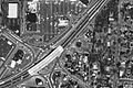
Built in 2009 at the entrance to Camden County College. 3 other traffic circles were built on college grounds, along with new service roads for improved safety and more accessibility to the college, near Route 42 and Route 168. [16]
Collingswood Circle 2021-07-15 10 38 20 View north along U.S. Route 130 (Crescent Boulevard) from the pedestrian overpass at Camden County Route 729 (Richey Avenue) in Collingswood, Camden County, New Jersey.jpg Collingswood
39°55′08″N75°05′20″W / 39.9189°N 75.0888°W / 39.9189; -75.0888 (Collingswood Circle)
Defunct US 30, US 130, White Horse Pike, Woodlynne AvenueReplaced by an at-grade intersection with jughandles in 2009. [11] [17]
Collingwood Circle Collingwood Circle, Wall, NJ.jpg Wall Township
40°13′09″N74°07′42″W / 40.2192°N 74.1284°W / 40.2192; -74.1284 (Collingwood Circle)
Route 33, Route 34, CR 547
Cooper Landing Circle Cherry Hill
39°56′26″N75°00′35″W / 39.9405°N 75.0098°W / 39.9405; -75.0098 (Cooper Landing Circle)
Modified Route 38, Cooper Landing Road, Church Road
Cranbury-Hightstown Circle Cranbury
40°17′31″N74°31′14″W / 40.2919°N 74.5205°W / 40.2919; -74.5205 (Cranbury-Hightstown Circle)
US 130, CR 539, Old Trenton Road (CR 685)
Dvoor's Circle / Route 12 Circle NJ 12 CR 523 Circle.jpg Raritan Township
40°30′16″N74°52′16″W / 40.5044°N 74.8712°W / 40.5044; -74.8712 (Route 12 Circle)
Route 12, CR 523, Mine Street
Eatontown Circle Eatontown
40°17′27″N74°03′06″W / 40.2909°N 74.0518°W / 40.2909; -74.0518 (Eatontown Circle)
Defunct Route 35, Route 36
Eisenhower Traffic Circle [18] Eisenhower Traffic Circle, Lakehurst.jpg Lakehurst
40°00′42″N74°19′33″W / 40.0117°N 74.3259°W / 40.0117; -74.3259 (Union Avenue Circle)
Route 70, Union Avenue, South Union Avenue, Pine Street, Myrtle Avenue
Ellisburg Circle Cherry Hill
39°54′50″N75°00′37″W / 39.9138°N 75.0102°W / 39.9138; -75.0102 (Ellisburg Circle)
Defunct Route 41, Route 70, Route 154 [3]
Flemington Circle Flemington circle usgs.jpg Flemington
40°30′09″N74°51′12″W / 40.5026°N 74.8534°W / 40.5026; -74.8534 (Flemington Circle)
US 202, Route 12, Route 31 To be replaced with a modern roundabout. [19]
Four Mile Circle Four Mile Circle from Route 70 westbound crop.jpg Southampton, Pemberton Township
39°53′56″N74°35′47″W / 39.8989°N 74.5963°W / 39.8989; -74.5963 (Four Mile Circle)
Route 70, Route 72, Magnolia Road (CR 644), New Lisbon Road (CR 646)
Franklin Lake Circle Franklin Lakes
40°59′37″N74°12′44″W / 40.9935°N 74.2123°W / 40.9935; -74.2123 (Franklin Lake Circle)
Franklin Lake Road, High Mountain Road
Freehold Circle Freehold Township
40°15′33″N74°17′28″W / 40.2592°N 74.2912°W / 40.2592; -74.2912 (Freehold Circle)
Defunct US 9, Route 33 Bus., Manalapan Avenue
General Circle Fort Dix 40°01′00″N74°38′09″W / 40.0167°N 74.6358°W / 40.0167; -74.6358 Modified Route 68, Pemberton-Wrightstown Road, 4th StreetFormerly served Fort Dix Road
Green Street Circle Woodbridge 40°33′46″N74°18′01″W / 40.5629°N 74.3003°W / 40.5629; -74.3003 Defunct US 1, Green Street
Ho-Ho-Kus Circle Ho-Ho-Kus 40°59′36″N74°05′46″W / 40.9933°N 74.0962°W / 40.9933; -74.0962 Defunct Route 17, Racetrack Road
Lakehurst Circle Lakehurst Circle.jpg Lakehurst
40°00′46″N74°18′19″W / 40.0128°N 74.3052°W / 40.0128; -74.3052 (Lakehurst Circle)
Route 37, Route 70
Laurelton Circle Brick
40°04′08″N74°07′49″W / 40.0688°N 74.1303°W / 40.0688; -74.1303 (Laurelton Circle)
Defunct Route 70, Route 88, CR 630 in 1986,
Ledgewood Circle Ledgewoodcircle1994.jpg Ledgewood in Roxbury
40°52′44″N74°39′03″W / 40.8790°N 74.6508°W / 40.8790; -74.6508 (Ledgewood Circle)
Defunct US 46, Route 10, Circle Drive [1]
Converted to 3-way signaled intersection (late 1990s)
Linden Circle Linden
40°38′24″N74°17′16″W / 40.6399°N 74.2879°W / 40.6399; -74.2879 (Linden Circle)
DefunctRaritan Road (CR 607), Centennial Avenue (CR 615)
Little Ferry Circle Little Ferry
40°51′10″N74°02′02″W / 40.8529°N 74.0340°W / 40.8529; -74.0340 (Little Ferry Circle)
Defunct US 46, Bergen Turnpike [20]

[21] [22]

Livingston Circle Livingston
40°47′47″N74°20′29″W / 40.7963°N 74.3413°W / 40.7963; -74.3413 (Livingston Circle)
Modified Eisenhower Parkway, Route 10 (Mt. Pleasant Avenue), West Northfield Road
Main Street Circle Main Street Circle, Flemington, NJ.jpg Flemington
40°30′06″N74°51′31″W / 40.5018°N 74.8586°W / 40.5018; -74.8586 (Main Street Circle)
Route 12, Main Street, South Main Street, Reaville Avenue
Manasquan Circle Wall Township
40°07′56″N74°03′55″W / 40.1323°N 74.0652°W / 40.1323; -74.0652 (Manasquan Circle)
Route 35, CR 524 Spur
Maple Shade Circle Maple Shade 39°56′36″N74°58′43″W / 39.9432°N 74.9785°W / 39.9432; -74.9785 Defunct Route 38, Route 41, Route 73
Marlton Circle Marlton circle.jpg Marlton in Evesham Township
39°53′38″N74°55′40″W / 39.8938°N 74.9278°W / 39.8938; -74.9278 (Marlton Circle)
Defunct Route 70, Route 73 Replaced with an interchange in 2011. [23]
McKee City Circle Egg Harbor Township
39°27′02″N74°38′33″W / 39.4505°N 74.6424°W / 39.4505; -74.6424 (Cardiff Circle)
Defunct US 40, US 322 Teardrop-shaped circle where US 40 and US 322 split. Replaced with a jughandle intersection.
Medford Circle Medford
39°54′17″N74°49′28″W / 39.9047°N 74.8244°W / 39.9047; -74.8244 (Medford Circle)
Defunct Route 70, CR 541
Monument Circle Englewood
40°53′48″N73°58′47″W / 40.8967°N 73.9797°W / 40.8967; -73.9797 (Soldier's Monument in Monument Circle) [24]
CR 505 (West Palisade Avenue), Tenafly Road, Bennett Road, Lafayette Avenue
Morlot Avenue Bridge Circle Paterson
40°55′23″N74°08′29″W / 40.9230°N 74.1413°W / 40.9230; -74.1413 (Morlot Avenue Bridge Circle)
Defunct Route 20, 10th Avenue (CR 651)
Netcong Circle Netcong
40°53′48″N74°42′01″W / 40.8968°N 74.7003°W / 40.8968; -74.7003 (Netcong Circle)
Defunct US 46, Route 183 Converted to 4-way intersection (August 2013)
Park and Passaic Avenues[ citation needed ] Rutherford
40°49′35″N74°06′26″W / 40.8263°N 74.1072°W / 40.8263; -74.1072
Modified
Pavilion Circle Cape May Point 38°56′16″N74°58′00″W / 38.9379°N 74.9668°W / 38.9379; -74.9668 Cape Avenue, Pavillion Avenue, Central Avenue, Oxford Avenue, Ocean Avenue
Penhorn Circle North Bergen 40°46′25″N74°02′31″W / 40.7736°N 74.042°W / 40.7736; -74.042 Defunct US 1/9, Route 3
Pennington Circle Pennington Circle, NJ.jpg Pennington
40°18′30″N74°47′12″W / 40.3082°N 74.7866°W / 40.3082; -74.7866 (Pennington Circle)
Route 31, CR 546, Pennington Road (CR 640) Metering lights added in late 2015 [25]
Penns Neck Circle US 1 NB at CR 526-CR 571 NJ.JPG Penns Neck in West Windsor
40°19′53″N74°38′17″W / 40.3315°N 74.6380°W / 40.3315; -74.6380 (Penns Neck Circle)
Modified US 1, CR 526/CR 571
Pole Tavern Circle Upper Pittsgrove Township
39°37′01″N75°13′46″W / 39.6170°N 75.2294°W / 39.6170; -75.2294 (Pole Tavern Circle)
US 40, Route 77, Monroeville Road (CR 604), Daretown Road (CR 635)
Pompton Plains Circle / Jackson Circle Pequannock 40°58′08″N74°17′09″W / 40.9689°N 74.2859°W / 40.9689; -74.2859 Defunct Route 23, Jackson Avenue
Pudgy Circle McGuire AFB, New Hanover
40°02′07″N74°35′12″W / 40.0354°N 74.5868°W / 40.0354; -74.5868 (Pudgy Circle)
McGuire Boulevard, 1st Street
Race Track Circle Cherry Hill
39°55′10″N75°02′03″W / 39.9194°N 75.0343°W / 39.9194; -75.0343 (Race Track Circle)
Defunct Route 70, Haddonfield Road (CR 644) [3]
Ramsey Circle Ramsey 41°04′08″N74°08′09″W / 41.0688°N 74.1357°W / 41.0688; -74.1357 Defunct Route 17, CR 507
Red Lion Circle 2014-08-27 10 57 36 View of the Red Lion Circle from the west.JPG Southampton
39°53′14″N74°44′28″W / 39.8872°N 74.7411°W / 39.8872; -74.7411 (Red Lion Circle)
US 206, Route 70
Ratzer Road Circle Wayne 40°56′47″N74°16′26″W / 40.9465°N 74.2739°W / 40.9465; -74.2739 Defunct Route 23, US 202, CR 504
Ridgefield Circle Ridgefield
40°49′59″N74°00′37″W / 40.8331°N 74.0103°W / 40.8331; -74.0103 (Ridgefield Circle)
Defunct US 1, Route 93, Hendricks Causeway
Ridgewood Circle Ridgewood 40°58′59″N74°05′20″W / 40.9831°N 74.0888°W / 40.9831; -74.0888 Defunct Route 17, Paramus Road, E Saddle River Road
Riverdale Circle Riverdale 40°59′07″N74°18′12″W / 40.9853°N 74.3033°W / 40.9853; -74.3033 Defunct Route 23, CR 511 Alt., Windbeam Road
Ross Dock Circle Fort Lee 40°51′28″N73°57′32″W / 40.8577°N 73.959°W / 40.8577; -73.959 Henry Hudson Drive, road to Ross Dock
Rosedale Circle Princeton 40°20′45″N74°41′17″E / 40.34571°N 74.68806°E / 40.34571; 74.68806
Routes 1 & 130 Circle North Brunswick
40°27′46″N74°27′19″W / 40.4627°N 74.4553°W / 40.4627; -74.4553 (Routes 1 & 130 Circle)
Defunct US 1, US 130, Route 171 Replaced by at-grade intersection, now an interchange.
Sharon Station Road Upper Freehold
40°08′56″N74°32′24″W / 40.149°N 74.54°W / 40.149; -74.54 (Sharon Station Road)
Recent CR 539, CR 539AOpened in 2022. [26]
Somers Point Circle NJ 52 northbound leaving Somers Point Circle.jpg Somers Point
39°18′31″N74°35′57″W / 39.3087°N 74.5993°W / 39.3087; -74.5993 (Somers Point Circle)
Defunct Route 52, CR 559, CR 585 Replaced by an intersection with traffic signals. [27] [28]
Somerville Circle Somerville circle usgs.jpg Bridgewater and Raritan
40°34′33″N74°37′44″W / 40.5757°N 74.6290°W / 40.5757; -74.6290 (Somerville Circle)
Modified US 202, US 206, Route 28 An overpass and traffic lights were added in the 1990s. [6]
Station Square Rutherford NJT train station 2.jpg Rutherford
40°49′42″N74°06′04″W / 40.8284°N 74.1011°W / 40.8284; -74.1011 (Station Square)
ModifiedPark Avenue, Orient Way, Union Avenue, and Erie AvenueRebuilt August 2003 - 2005
Still Valley Circle Pohatcong 40°40′24″N75°08′19″W / 40.673333°N 75.138611°W / 40.673333; -75.138611 Defunct US 22, US 22 Alt., Still Valley Road
Teaneck Circle Teaneck 40°53′03″N74°00′26″W / 40.8843°N 74.0073°W / 40.8843; -74.0073 DefunctTeaneck Road, Cedar Lane
Tonnele Circle Tonnelle circle usgs.jpg Jersey City
40°44′22″N74°03′55″W / 40.7394°N 74.0654°W / 40.7394; -74.0654 (Tonnele Circle)
Modified US 1/9, US 1/9 Truck, Route 139, Tonnele Avenue
Veterans' Memorial Circle Vineland 39°29′36″N75°01′22″W / 39.4934°N 75.0229°W / 39.4934; -75.0229 N 6th St, Cambridge St
Victory Circle Victory Circle, NJ in the 1990s.tif Sayreville
40°29′46″N74°17′52″W / 40.4962°N 74.2978°W / 40.4962; -74.2978 (Victory Circle)
Defunct US 9, Route 35, Chevalier Avenue, Main StreetReplaced with a diamond interchange in 2006. [29]
Vineland CircleVineland 39°29′13″N75°02′35″W / 39.487°N 75.0431°W / 39.487; -75.0431 Defunct Route 47, Route 56, Landis Ave
War Memorial Circle
WWI Memorial Atlantic City a.JPG
Atlantic City 39°21′04″N74°27′17″W / 39.3512°N 74.4548°W / 39.3512; -74.4548 Defunct US 40, US 322, Albany Ave, Ventnor Ave
Watchung Circle Mountainside
40°41′14″N74°21′50″W / 40.6872°N 74.3639°W / 40.6872; -74.3639 (Watchung Circle)
W R Tracy Drive (CR 645), Summit Lane (CR 642)
Westfield Circle 2021-09-20 09 35 37 View west along New Jersey Route 28, south along County Route 509 and east along County Route 610 (Broad Street) from the overpass for the rail line between South Avenue and North Avenue in Westfield, Union County, New Jersey.jpg Westfield
40°38′55″N74°21′01″W / 40.6485°N 74.3503°W / 40.6485; -74.3503 (Westfield Circle)
CR 509, South Avenue (CR 610), Route 28, Westfield Avenue, Watterson StreetExpanded to two lanes in 2005 with one way designations added to Watterson Street (Inbound), and Westfield Avenue (Outbound)
White Horse Circle White Horse in Hamilton
40°11′18″N74°42′17″W / 40.1882°N 74.7048°W / 40.1882; -74.7048 (White Horse Circle)
Modified US 206, CR 524, CR 533
Willowbrook Circle Wayne 40°53′37″N74°15′06″W / 40.8936°N 74.2516°W / 40.8936; -74.2516 Defunct US   46, Route 23, CR 703 Replaced by a spaghetti bowl interchange with the construction of I-80
Brooklawn 39°52′38″N75°07′12″W / 39.8772°N 75.1201°W / 39.8772; -75.1201 Noreg Place, Christiana St, Maude Ave
Brooklawn 39°52′41″N75°07′19″W / 39.8781°N 75.1220°W / 39.8781; -75.1220 Wilson Avenue, Horton Avenue, Tommy McAdams Way
Pohatcong 40°40′52″N75°08′50″W / 40.6812°N 75.1471°W / 40.6812; -75.1471 Defunct US 22, CR 519
Washington 40°45′34″N74°58′30″W / 40.7594°N 74.975°W / 40.7594; -74.975 Defunct Route 31, Route 57
Egg Harbor Township 39°24′01″N74°33′40″W / 39.4002°N 74.5611°W / 39.4002; -74.5611 Defunct US 40, US 322, Black Horse Pike, Tilton Road
Wayne 40°55′30″N74°16′09″W / 40.924864°N 74.269058°W / 40.924864; -74.269058 Defunct Route 23, US 202, Newark-Pompton Turnpike Only operated as such southbound on Route 23; northbound side unimpeded
Paterson 40°54′09″N74°08′07″W / 40.9026°N 74.1354°W / 40.9026; -74.1354 Defunct Route 20, Market Street
Paterson 40°54′07″N74°08′28″W / 40.9019°N 74.1411°W / 40.9019; -74.1411 Market Street, Lakeview Avenue
Woodland Park 40°52′35″N74°12′04″W / 40.8764°N 74.2011°W / 40.8764; -74.2011 Great Notch Road, Notch Road, Rifle Camp Road, Lackawanna Avenue
Little Falls 40°52′21″N74°11′48″W / 40.8725°N 74.1966°W / 40.8725; -74.1966 Exit to US 46, Clove Road, entrance to Overlook Corporate Center
Perth Amboy 40°31′43″N74°16′48″W / 40.5286°N 74.28°W / 40.5286; -74.28 Defunct Route 35, Route 440 (now partly Route 184)
Cherry Hill 39°56′18″N75°01′48″W / 39.9384°N 75.03°W / 39.9384; -75.03 Defunct Route 38, Haddonfield Road
Old Bridge Township 40°24′36″N74°21′43″W / 40.409894°N 74.361872°W / 40.409894; -74.361872 Defunct NJ 18, CR 516, CR 527
Fort Dix 40°01′47″N74°37′08″W / 40.0298°N 74.6188°W / 40.0298; -74.6188 CR 545, Pemberton-Wrightstown Road, Delaware Avenue, Neely Road
Fort Dix 40°01′45″N74°36′41″W / 40.0291°N 74.6115°W / 40.0291; -74.6115 Broidy Road, Wonnacott Avenue
New Hanover 40°02′08″N74°35′12″W / 40.0355°N 74.5868°W / 40.0355; -74.5868 West Tuskegee Airmen Avenue, McGuire Blvd
New Hanover 40°01′40″N74°35′06″W / 40.0279°N 74.585°W / 40.0279; -74.585 McGuire Boulevard, Arnold Avenue
Alpine 40°56′23″N73°55′18″W / 40.9398°N 73.9216°W / 40.9398; -73.9216 Henry Hudson Drive, Hudson Drive
Jersey City 40°41′59″N74°04′02″W / 40.6998°N 74.0672°W / 40.6998; -74.0672 Bayview Ave, Burma Road, Morris Pesin Drive
Bayonne 40°40′57″N74°05′57″W / 40.6826°N 74.0991°W / 40.6826; -74.0991 Avenue EExits on the north side of the circle divide access to the east and westbound ramps of I-78

Related Research Articles

<span class="mw-page-title-main">New Jersey Turnpike</span> Toll road in New Jersey

The New Jersey Turnpike (NJTP) is a system of controlled-access highways in the U.S. state of New Jersey. The turnpike is maintained by the New Jersey Turnpike Authority. The 117.2-mile (188.6 km) mainline's southern terminus is at the Delaware Memorial Bridge on I-295 in Pennsville. Its northern terminus is at an interchange with I-80 and US 46 in Ridgefield Park. Construction of the mainline, from concept to completion, took a total of 22 months between 1950 and 1951. It was opened to traffic on November 5, 1951, between its southern terminus and exit 10.

<span class="mw-page-title-main">New Jersey Route 18</span> State highway in central New Jersey, US

Route 18 is a 47.9-mile-long (77.1 km) state highway in the central part of the US state of New Jersey. It begins at an intersection with Route 138 in Wall Township, Monmouth County and ends at Interstate 287 (I-287) in Piscataway, Middlesex County. Route 18 is a major route through Central New Jersey that connects the Jersey Shore to the Raritan Valley region, connecting the county seats of Monmouth (Freehold) and Middlesex respectively. The route runs through Ocean Township, Marlboro, East Brunswick, and is the main thoroughfare for Rutgers University. Much of the route is a freeway. The remainder of the route is an arterial road with traffic lights in the East Brunswick and Old Bridge areas, and a boulevard in the remainder of Piscataway. Route 18 was designated in 1939 as a proposed freeway from Old Bridge to Eatontown. The section west of Old Bridge was formerly designated as part Route S28, a prefixed spur of State Highway Route 28 from Middlesex to Matawan. The designation, assigned in the 1927 renumbering, remained until a second renumbering in 1953. At that point, Route S28 was redesignated as Route 18, though the section from Old Bridge to Matawan was signed as TEMP 18, as this section would be decommissioned when the Route 18 freeway was built.

<span class="mw-page-title-main">New Jersey Route 35</span> State highway in eastern New Jersey, US

Route 35 is a state highway in the U.S. state of New Jersey, primarily traveling through the easternmost parts of Middlesex, Monmouth, and Ocean counties. It runs 58.11 mi (93.52 km) from the entrance to Island Beach State Park in Berkeley Township, Ocean County to an intersection with Route 27 in Rahway, Union County. Between Seaside Park and Mantoloking, Route 35 follows the right-of-way of the former Pennsylvania Railroad along the Jersey Shore. The route heads through Point Pleasant Beach and crosses the Manasquan River on the Brielle Bridge, meeting Route 34 and Route 70 at the former Brielle Circle in Wall Township. From there, Route 35 heads north and intersects Route 138, an extension of Interstate 195, continuing north through Monmouth County before crossing the Victory Bridge over the Raritan River into Perth Amboy, where the route continues north to Rahway.

<span class="mw-page-title-main">New Jersey Route 70</span> Highway in New Jersey

Route 70 is a state highway located in the U.S. state of New Jersey. It extends 59.84 mi (96.30 km) from an interchange with Route 38 in Pennsauken Township, Camden County, east to an intersection with Route 34 and Route 35 in Wall Township, Monmouth County. Route 70 cuts across the middle of the state as a two-lane highway through the Pine Barrens in Burlington and Ocean counties. A popular truck route, it provides access between Philadelphia and the surrounding Delaware Valley metropolitan area and the Jersey Shore resorts, particularly Long Beach Island by way of Route 72. It is also a congested commercial route within Philadelphia's New Jersey suburbs. The western section in Cherry Hill and Marlton is a four- to eight-lane divided highway that serves as a major suburban arterial and is locally known as Marlton Pike. The eastern section in Monmouth and Ocean counties is also a multilane divided highway that runs through suburban areas. Route 70 is officially known as the John Davison Rockefeller Memorial Highway its entire length in honor of John Davison Rockefeller.

<span class="mw-page-title-main">New Jersey Route 29</span> Highway in New Jersey

Route 29 is a state highway in the U.S. state of New Jersey. Signed north-south, it runs 34.76 mi (55.94 km) from an interchange with Interstate 295 (I-295) in Hamilton Township in Mercer County, where the road continues east as I-195, northwest to Route 12 in Frenchtown, Hunterdon County. Between the southern terminus and I-295 in Ewing Township, the route is a mix of expressway and boulevard that runs along the Delaware River through Trenton. This section includes a truck-restricted tunnel that was built along the river near historic houses and Riverview Cemetery. North of I-295, Route 29 turns into a scenic and mostly two-lane highway. North of the South Trenton Tunnel, it is designated the Delaware River Scenic Byway, a New Jersey Scenic Byway and National Scenic Byway, that follows the Delaware River in mostly rural sections of Mercer County and Hunterdon County. The obsolete Delaware & Raritan Canal usually stands between the river and the highway. Most sections of this portion of Route 29 are completely shaded due to the tree canopy. Route 29 also has a spur, Route 129, which connects Route 29 to U.S. Route 1 (US 1) in Trenton.

<span class="mw-page-title-main">New Jersey Route 42</span> Highway in New Jersey

Route 42 is a state highway in the U.S. state of New Jersey within the Camden area. It runs 14.28 mi (22.98 km) from an intersection with U.S. Route 322 and County Route 536 Spur in Monroe Township, Gloucester County, to an intersection with Interstate 76 (I-76) and I-295 in Bellmawr, Camden County. The southern portion of Route 42 is an four-lane divided highway and one of several highways comprising the Black Horse Pike, a road that runs from Camden to Atlantic City. The northern portion is part of a six- to eight-lane freeway referred to locally as the North–South Freeway that connects the Atlantic City Expressway to the Benjamin Franklin Bridge. Major junctions along the route include the Atlantic City Expressway and the southern terminus of Route 168 in Turnersville, Route 168 in Blackwood, and Route 41 and Route 55 in Deptford Township.

<span class="mw-page-title-main">New Jersey Route 52</span> State highway in southern, New Jersey, US

Route 52 is a state highway in the southern part of the U.S. state of New Jersey. The highway runs 2.74 mi (4.41 km) from 9th Street in Ocean City, Cape May County north to U.S. Route 9 in Somers Point, Atlantic County. It is composed mostly of a series of four-lane divided bridges over Great Egg Harbor Bay from Ocean City to Somers Point known as the Howard S. Stainton Memorial Causeway, also known as the Ninth Street Bridge. The remainder of the route is a surface road called MacArthur Boulevard that runs from the causeway to US 9. This section of the route formerly included the Somers Point Circle, now a traffic light, where Route 52 intersects County Route 559 and CR 585.

<span class="mw-page-title-main">New Jersey Route 72</span> State highway in New Jersey, US

Route 72 is a state highway in the U.S. state of New Jersey. It runs 28.74 mi (46.25 km) from the Four Mile Circle with Route 70 in Woodland Township in Burlington County to County Route 607 in Ship Bottom on Long Beach Island in Ocean County. Route 72 travels through the Pine Barrens as a two-lane undivided road. After an interchange with the Garden State Parkway, the route becomes a four- to six-lane divided highway through built-up areas of Manhawkin and crosses the Manahawkin Bay via the Manahawkin Bay Bridge onto Long Beach Island.

<span class="mw-page-title-main">New Jersey Route 73</span> State highway in southern, New Jersey, US

Route 73 is a state highway in the southern part of the U.S. state of New Jersey. It runs 34.64 mi (55.75 km) as an outer bypass of the Camden area from an intersection with U.S. Route 322 (US 322) in Folsom, Atlantic County, north to the Tacony–Palmyra Bridge in Palmyra, Burlington County, where the road continues into Philadelphia, Pennsylvania, as Pennsylvania Route 73. South of the interchange with the Atlantic City Expressway in Winslow Township, Camden County, Route 73 is a two-lane undivided county-maintained road and is signed as County Route 561 Spur, a spur of CR 561. North of the Atlantic City Expressway, the route is maintained by the New Jersey Department of Transportation and is mostly four lanes, with the portion north of the CR 561 concurrency a divided highway. North of the US 30 interchange near Berlin, Route 73 runs through suburban areas of the Delaware Valley metropolitan area, intersecting Route 70 in Marlton, the New Jersey Turnpike and Interstate 295 (I-295) in Mount Laurel Township, Route 38 and Route 41 in Maple Shade Township, Route 90 in Cinnaminson Township, and US 130 in Pennsauken Township.

<span class="mw-page-title-main">New Jersey Route 139</span> State highway in Hudson County, New Jersey, US

Route 139 is a state highway in Jersey City, New Jersey in the United States that heads east from the Pulaski Skyway over Tonnele Circle to the state line with New Jersey and New York in the Holland Tunnel, which is under the Hudson River, to New York City. The western portion of the route is a two-level highway that is charted by the New Jersey Department of Transportation (NJDOT) as two separate roadways: The 1.45-mile (2.33 km) lower roadway (Route 139) between U.S. Route 1/9 (US 1/9) over Tonnele Circle and Interstate 78 (I-78) at Jersey Avenue, and the 0.83-mile (1.34 km) upper roadway running from County Route 501 and ending where it joins the lower highway as part of the 12th Street Viaduct, which ends at Jersey Avenue. The lower roadway is listed on the federal and NJ state registers of historic places since 2005. The eastern 1.32 miles (2.12 km) of the route includes the Holland Tunnel approach that runs concurrent with Interstate 78 on the one-way pair of 12th Street eastbound and 14th Street westbound. Including the concurrency, the total length of Route 139 is 2.77 miles (4.46 km).

<span class="mw-page-title-main">Garden State Parkway</span> Toll road in New Jersey

The Garden State Parkway (GSP) is a controlled-access, tolled highway that stretches the north–south length of eastern New Jersey from the state's southernmost tip near Cape May north to the New York state line at Montvale. Its name refers to New Jersey's nickname, the "Garden State". The parkway has an unsigned reference number of Route 444 by the New Jersey Department of Transportation (NJDOT). At its north end, the road becomes the Garden State Parkway Connector, a component of the New York State Thruway system that connects to the Thruway mainline in Ramapo.

<span class="mw-page-title-main">New Jersey Route 440</span> State highway in Hudson and Middlesex counties in New Jersey, United States

Route 440 is a state highway in New Jersey, United States. It comprises two segments, a 5.15-mile (8.29 km) freeway in Middlesex County linking Interstate 287 (I-287) and the New Jersey Turnpike (I-95), in Edison to the Outerbridge Crossing in Perth Amboy and an 8.18-mile (13.16 km) four-lane divided highway in Hudson County running from the Bayonne Bridge in Bayonne to U.S. Route 1/9 Truck in Jersey City. These two segments are connected by New York State Route 440 (NY 440), which runs across Staten Island. The freeway portion in Middlesex County is six lanes wide and interchanges with the Garden State Parkway and US 9 in Woodbridge.

<span class="mw-page-title-main">New Jersey Department of Transportation</span> Government agency

The New Jersey Department of Transportation (NJDOT) is the agency responsible for transportation issues and policy in New Jersey, including maintaining and operating the state's highway and public road system, planning and developing transportation policy, and assisting with rail, freight, and intermodal transportation issues. It is headed by the Commissioner of Transportation. The present acting commissioner is Francis K. O'Connor.

<span class="mw-page-title-main">Interstate 295 (Delaware–Pennsylvania)</span> Interstate Highway in the US states of Delaware, New Jersey, and Pennsylvania

Interstate 295 (I-295) in Delaware, New Jersey, and Pennsylvania is an auxiliary Interstate Highway, designated as a bypass around Philadelphia, Pennsylvania, and a partial beltway of Trenton, New Jersey.

<span class="mw-page-title-main">Interstate 80 in New Jersey</span> Highway in New Jersey

Interstate 80 (I-80) is a major Interstate Highway in the United States, running from San Francisco, California, eastward to the New York metropolitan area. In New Jersey, I-80 runs for 68.35 miles (110.00 km) from the Delaware Water Gap Toll Bridge at the Pennsylvania state line to its eastern terminus at I-95 in Teaneck, Bergen County. I-95 continues from the end of I-80 to the George Washington Bridge for access to New York City. The highway runs parallel to U.S. Route 46 (US 46) through rural areas of Warren and Sussex counties before heading into more suburban surroundings in Morris County. As the road continues into Passaic and Bergen counties, it heads into more urban areas. The New Jersey Department of Transportation (NJDOT) identifies I-80 within the state as the Christopher Columbus Highway.

<span class="mw-page-title-main">U.S. Route 9 in New Jersey</span> Highway in New Jersey

U.S. Route 9 (US 9) is a United States Numbered Highway in the Mid-Atlantic region of the United States, running from Laurel, Delaware, to Champlain, New York. In New Jersey, the route runs 166.80 miles (268.44 km) from the Cape May–Lewes Ferry terminal in North Cape May, Cape May County, where the ferry carries US 9 across the Delaware Bay to Lewes, Delaware, north to the George Washington Bridge in Fort Lee, Bergen County, where the route along with Interstate 95 (I-95) and US 1 continue into New York City. US 9 is the longest U.S. Highway in the state.

<span class="mw-page-title-main">Berlin Circle (traffic circle)</span> Former traffic circle in Berlin Township, New Jersey

The Berlin Circle was a traffic circle in Berlin Township, New Jersey, United States located at the intersection of Route 73, Berlin-Cross Keys Road and Walker Avenue, and which also received traffic from nearby U.S. Route 30, and County Route 561. The New Jersey Department of Transportation (NJDOT) began replacement of the circle in August 2006. The project cost $73 million. The circle was replaced with an at-grade intersection with traffic signals. The project was completed in 2007.

The Black Horse Pike is a designation used for a number of different roadways that had been part of a historic route connecting the Camden area to the area of Atlantic City, New Jersey. Roadways now bearing the Black Horse Pike designation include portions of Route 168, Route 42, U.S. Route 322 (US 322), and US 40.

<span class="mw-page-title-main">Transportation in New Jersey</span>

Transportation in New Jersey utilizes a combination of road, rail, air, and water modes. New Jersey is situated between Philadelphia and New York City, two major metropolitan centers of the Boston-Washington megalopolis, making it a regional corridor for transportation. As a result, New Jersey's freeways carry high volumes of interstate traffic and products. The main thoroughfare for long distance travel is the New Jersey Turnpike, the nation's fifth-busiest toll road. The Garden State Parkway connects the state's densely populated north to its southern shore region. New Jersey has the 4th smallest area of U.S. states, but its population density of 1,196 persons per sq. mi causes congestion to be a major issue for motorists.

<span class="mw-page-title-main">New Jersey Route 183</span> State highway in Morris and Sussex Counties in New Jersey, United States

Route 183 is a 2.12-mile (3.41 km) long state highway in the northern regions of New Jersey. The southern end of the route is at an interchange with Interstate 80 and U.S. Route 206 (US 206) near Netcong, while the northern end is at an interchange with US 206 in Stanhope. The route heads northward through downtown Netcong and along the shores of Lake Musconetcong and enters Sussex County, New Jersey. The route is a former alignment of US 206 bypassed in 1973.

References

  1. 1 2 3 4 Peterson, Iver (November 12, 1991). "Squaring Traffic Circles With Lights and Bridges". The New York Times. Retrieved July 28, 2008.
  2. Capuzzo, Jill P. (November 25, 2007). "A Shift, but for Some Drivers, a Vicious Circle". The New York Times. Retrieved July 28, 2008.
  3. 1 2 3 4 5 Walsh, Jim (July 29, 2006). "Circles slow to roll off South Jersey roadways". Courier-Post. Retrieved July 28, 2008.[ permanent dead link ]
  4. Africano, Lillian; Africano, Nina (2006). You Know You're in New Jersey When...: 101 Quintessential Places, People, Events, Customs, Lingo, and Eats of the Garden State. Guilford, Connecticut: Globe Pequot. p. 90. ISBN   0-7627-3939-8.
  5. http://www.northjersey.com/news/bergen/bergen_safety/164195466_Road_Warrior__A_silver_bullet_for_ensuring_safety__way_to__manage__traffic_.html?c=y&page=1%5B%5D
  6. 1 2 Newman, Andy (January 28, 1996). "Road and Rail; Straightening Out the Perilous Somerville Circle". The New York Times. Retrieved July 28, 2008.
  7. 1 2 Dwyer, Christopher. "Buchart-Horn Designs Replacement For Bygone Transportation System". Buchart Horn, Inc. & BASCO Associates. Archived from the original on August 13, 2007. Retrieved July 28, 2008.
  8. "Roadwork at Egg Harbor Township's Airport Circle will cause delays next week". Press of Atlantic City. April 8, 2011. Retrieved February 28, 2012.
  9. "New Dinky station to open Nov. 17, marking Arts and Transit Project milestone". Princeton University. November 3, 2014. Retrieved May 29, 2016.
  10. "New Princeton Alexander Street Roundabout Is Open!". Walkable Princeton. February 3, 2014. Retrieved May 29, 2016.
  11. 1 2 Ozbay, Kaan; Bartin, Bekir; Rathi, Neha; List, George F.; Demers, Alixandra; Wojtowicz, Jeffrey (December 2008). Operational Improvements at Traffic Circles (PDF) (Report). New Jersey Department of Transportation. FHWA-NJ-2008-012.
  12. "NJDOT announces Route 73 traffic shift as part of Berlin Circle replacement" (Press release). New Jersey Department of Transportation. September 7, 2006. Retrieved March 15, 2024. The Berlin Circle replacement began in August 2005 and extends for more than two miles of Route 73. NJDOT is eliminating the existing traffic circle and replacing it with a signalized intersection. New ramps and side roads will be constructed to maintain all existing traffic movements. The entire project consists of roadway widening, reconstruction, drainage improvements and safety improvements for Route 73, Route 30, Berlin Cross Keys Road and Walker Avenue.
  13. "DiFrancesco and Weinstein Open Newly Reconfigured Interchange, Formerly Known as the Brielle Circle" (Press release). New Jersey Department of Transportation. May 17, 2001. Retrieved March 15, 2024. Transportation in Monmouth and Ocean counties was boosted significantly today when acting Governor Donald T. DiFrancesco and Transportation Commissioner James Weinstein today flipped a switch that initialized the traffic signal system and officially opened the newly reconfigured interchange of routes 34, 35 and 70 in Wall Township.... The new interchange, which eliminated the Brielle Circle, is part of a larger $23 million project to add a second travel lane to Route 70 in Brick, Ocean County. The widening project, extending 4.7 miles from Jack Martin Boulevard in Brick to the old Brielle Circle, is scheduled to finish by July.
  14. "Camp Merritt commemorated, 100 years later". Northern Valley Press. November 7, 2017. Retrieved March 15, 2024. During the 1918 influenza epidemic, 578 people died while at the camp (558 enlisted men, four nurses and one civilian). Their names are inscribed on the 66-foot memorial that is situated at the traffic circle on Knickerbocker Road and Madison Avenue.
  15. "Clark Circle". Union County Bureau of Traffic Safety & Maintenance. October 8, 2007. Archived from the original on October 15, 2007. Retrieved August 8, 2008.
  16. "College Drive Roundabout at Camden County College" . Retrieved January 17, 2013.
  17. Rosen, Jeremy (October 12, 2009). "Marlton Circle in for more changes". The Courier-Post . Retrieved October 28, 2009.[ dead link ]
  18. New Jersey Department of Transportation. "Speed Limits for State Roads - Route NJ 70" . Retrieved February 7, 2015. (A) Zone 1: 55 MPH between the Manchester Township – Lakehurst Borough westerly corporate line and South Union Avenue (Eisenhower Traffic Circle)
  19. "Confusing Flemington traffic circles to go in new directions". The Star-Ledger. March 15, 2009. Retrieved May 22, 2009.
  20. Furschein, Merry (March 30, 2007). "DOT releases new plan to fix Little Ferry circle". The Record . Woodland Park, New Jersey.
  21. Cichowski, John (March 25, 2017). "Little Ferry crashes soar at old 'circle'". NorthJersey.com.
  22. "FY 2007–10 Statewide Transportation Improvement Program" (PDF). New Jersey Department of Transportation.
  23. "NJDOT: Traffic pattern at Marlon Circle to change Monday morning". Medford Central Record. April 30, 2010. Retrieved January 9, 2011.
  24. "City of Englewood : Default". Archived from the original on December 3, 2014. Retrieved February 28, 2013.
  25. "Route 31 Pennington Circle Hopewell Township, Mercer County - Pre-Construction Public Information Center pamphlet" (PDF). New Jersey Department of Transportation. June 29, 2015. Retrieved November 15, 2015.
  26. https://www.co.monmouth.nj.us/documents/30/Sharon_Station_Rd_Roadway_Improvements.pdf
  27. Urgo, Jacqueline L. (February 10, 2008). "Bottleneck at Shore will be a breeze". The Philadelphia Inquirer. Archived from the original on February 12, 2008. Retrieved July 28, 2008.
  28. Good, Dan (October 18, 2010). "Local restaurants could lose business, as construction crews eliminate Somers Point traffic circle". Press of Atlantic City. Retrieved November 8, 2010.
  29. "Route 9 and 35 Victory Circle Elimination Project". New Jersey Department of Transportation. Retrieved July 28, 2008.