
Fort Bend County is a county located in the U.S. state of Texas. According to 2019 census estimates, its population was 811,688 and Texas's 10th-most populous county. In 2015, Fort Bend County became Texas's wealthiest county, with a median household income of $95,389 and a median family income of $105,944, surpassing Collin and Rockwall Counties since the 2000 census. The county seat is Richmond, and the largest city located entirely within the county borders is Sugar Land. The largest city by population in the county is Houston; however, most of Houston's population is located in neighboring Harris County.
Arcola is a city in Fort Bend County, Texas, United States, within the Houston–Sugar Land–Baytown metropolitan area. The population was 1,642 at the 2010 census, up from 1,048 at the 2000 census.
Fresno is an unincorporated community and census-designated place (CDP) in Fort Bend County, Texas, United States. The population was 19,069 at the 2010 census, up from 6,603 at the 2000 census.

Needville is a city in Fort Bend County, Texas, United States. It is within the Houston–Sugar Land metropolitan area. The population was 2,823 at the 2010 census.

Orchard is a city in western Fort Bend County, Texas, United States, within the Houston–Sugar Land–Baytown metropolitan area. The community is located along State Highway 36 (SH 36) and the BNSF Railway between Rosenberg in Fort Bend County and Wallis in Austin County. The population was 352 at the 2010 census, down from 408 at the 2000 census.

Sugar Land is the largest city in Fort Bend County, Texas, United States, located in the southwestern part of the Houston–The Woodlands–Sugar Land metropolitan area. Located about 19 miles (31 km) southwest of downtown Houston, Sugar Land is a populous suburban municipality centered around the junction of Texas State Highway 6 and U.S. Route 59.

East Bernard is a city in Wharton County, Texas, United States. The population was 2,272 at the 2010 census. U.S. Highway 90 Alternate (US 90A) and Texas State Highway 60 (SH 60) intersect within the city limits. East Bernard has its own school district, two auto dealerships and a number of other businesses. The San Bernard River flows past the city's eastern side.

Missouri City is a city in the U.S. state of Texas, within the Houston–The Woodlands–Sugar Land metropolitan area. The city is mostly in Fort Bend County, with a small portion in Harris County. As of the 2010 census, the city had a population of 67,358, up from 52,913 in 2000. The population was estimated at 75,457 in 2019.

Stafford is a city in the U.S. state of Texas, within the Houston–The Woodlands–Sugar Land metropolitan area. The city is mostly in Fort Bend County, with a small portion in Harris County. As of the 2010 census, Stafford's population was 17,693, up from 15,681 at the 2000 census. As of 2019, the population had decreased to an estimated 17,362.

The Santa Fe Trail was a 19th-century route through central North America that connected Franklin, Missouri with Santa Fe, New Mexico. Pioneered in 1821 by William Becknell, who departed from the Boonslick region along the Missouri River, the trail served as a vital commercial highway until 1880, when the railroad arrived in Santa Fe. Santa Fe was near the end of the El Camino Real de Tierra Adentro, which carried trade from Mexico City.
State Highway 6 runs from the Red River, the Texas–Oklahoma boundary, to northwest of Galveston, where it is known as the Old Galveston Highway. In Sugar Land and Missouri City, it is known as Alvin-Sugarland Road and runs perpendicular to I-69/US 59. In the Houston area, it runs north to FM 1960, then northwest along US Highway 290 to Hempstead, and south to Westheimer Road and Addicks, and is known as Addicks Satsuma Road. In the Bryan–College Station area, it is known as the Earl Rudder Freeway. In Hearne, it is known as Market Street. In Calvert, it is known as Main Street. For most of its length, SH 6 is not a limited-access road.

State Highway 118 is a 155.3-mile (249.9 km) state highway in the U.S. state of Texas that runs from Big Bend National Park north to Kent and passes through the towns of Study Butte, Alpine, and Fort Davis. SH 118 is maintained by the Texas Department of Transportation (TxDOT). The road lies entirely within the Trans-Pecos region of Texas. SH 118 is a two-lane road along its length except for a section in Alpine where the route follows the path of U.S. Route 67 and U.S. Route 90. All of the route except for the 2.8-mile (4.5 km) section between Big Bend National Park and Farm to Market Road 170 is included in the Texas Historical Commission's Texas Mountain Trail.
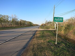
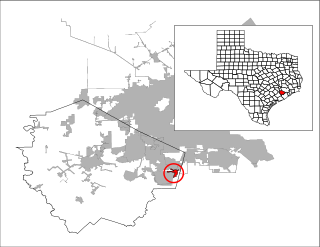
Juliff is an unincorporated community situated along Farm to Market Road 521 (FM 521) in eastern Fort Bend County, Texas, United States. The settlement was founded in the 1850s as a shipping point along the Brazos River and the railroad reached there in the same decade. The community received postal service in 1891, and except for a brief closure, retained it until the late 1950s. Starting in the 1930s, Juliff enjoyed a heyday as a place of raucous entertainment after local residents opened several taverns and dance halls. This era ended in the 1960s when the bars relocated to Houston. Sometime later, the railroad that ran alongside FM 521 was discontinued. In December 2013 the community was a collection of homes along the east side of FM 521.

For the manufacturer of power tools, see: DeWalt.
U.S. Highway 75 is a part of the United States Numbered Highway System that runs for 1,239 miles (1,994 km) from Dallas, Texas to Kittson County, Minnesota where it ends just short of the Canada–United States border. Within the State of Nebraska it is a state highway that enters Nebraska on the Kansas state line about 9 miles (14 km) south of Dawson and travels north across the extreme eastern portion of the state, to the Nebraska–Iowa border in South Sioux City where it crosses the Missouri River along a concurrency with Interstate 129. The northern 210 miles (340 km) of the route generally travels parallel to the Missouri River. The 87.32-mile (140.53 km) section between the I-680 interchange in Omaha and the Interstate 129 interchange is designated the Lewis & Clark Scenic Byway, one of nine scenic byways in the state.

Howellville or Howell is an unincorporated community in Harris County, Texas, United States, which has been absorbed by Greater Houston. The site is located at the intersection of Alief Clodine Road and Sugar Land Howell Road on the west side of Houston, approximately halfway between the original settlements of Clodine and Alief. There are no road signs identifying the place. The community began as a stop on a railroad line that no longer exists.
Farm to Market Road 1092 (FM 1092) is a state highway in the U.S. state of Texas that is within both Fort Bend and Harris Counties. The highway starts from State Highway 6 in Missouri City and goes north to Interstate 69/U.S. Route 59 in southwest Houston. The divided highway is also known as Murphy Road along its entire length. In 1995, the Texas Department of Transportation (TxDOT) renamed the highway Urban Road 1092, but signs and maps still show FM 1092.

U.S. Highway 71 is a U.S. highway that runs from Krotz Springs, LA to the Fort Frances–International Falls International Bridge at the Canadian border. In Arkansas, the highway runs from the Louisiana state line near Doddridge to the Missouri state line near Bella Vista. In Texarkana, the highway runs along State Line Avenue with US 59 and partially runs in Texas. Other areas served by the highway include Fort Smith and Northwest Arkansas.
The Houston Tap and Brazoria Railway was chartered in September 1856 to extend southward from Houston to West Columbia in Brazoria County. The railroad's nicknames were the Columbia Tap and the Sugar Road. The railway absorbed track from an earlier short-lived line and reached West Columbia in 1860. After the American Civil War, the railroad ran into serious financial difficulties and was sold to the Houston and Great Northern Railroad. It was the only railroad that failed to repay money borrowed from the Special School Fund and the only railroad that could trace its title to the State of Texas. The line operated as part of the Missouri Pacific Railroad until 1980 when it was bought by the Union Pacific Railroad. In 2014, the part of the line closest to downtown Houston existed only as the Columbia Tap Rail-Trail, the portion of the line between Houston and Arcola was still in service and the section between Arcola and West Columbia was abandoned.
Duke is a ghost town in Fort Bend County, in the U.S. state of Texas. The former settlement's location was west of Arcola along the BNSF Railway near Houston Southwest Airport. In 2014 the town site was no longer accessible by public roads.


