Tavener, Texas

Last updated

Tavener, Texas
Tavener TX Cotton Gin.JPG
Tavener cotton gin at US 90A and FM 1952
Relief map of Texas.png
Red pog.svg
Tavener
Usa edcp relief location map.png
Red pog.svg
Tavener
Coordinates: 29°32′24″N95°59′21″W / 29.54000°N 95.98917°W / 29.54000; -95.98917
Country United States
State Texas
County Fort Bend
Elevation
117 ft (36 m)
Time zone UTC-6 (Central (CST))
  Summer (DST) UTC-5 (CDT)
ZIP code
77435
Area code 979

Tavener is an unincorporated community in Fort Bend County, Texas, United States. It is a part of the Greater Houston metropolitan area.

Contents

History

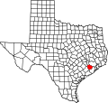
In 1890, the Texas and New Orleans Railroad added a stop and named it Tavener after Charlie Tavener, an early resident. The community received a post office in 1910. Four years later, the 25-person settlement boasted a lumberyard, general store, and telephone service. Postal service ceased in the 1930s. The community had a population of 50 and four commercial establishments in 1933. Only one business remained in 1945, but the number of residents remained steady. By 1953, only 20 people were recorded as living in the settlement. In 1970, the population was 30 persons. It continued to be listed on county maps in 1987, but there were no population estimates after that. [1]

Geography

Tavener is located 12 mi (19 km) west of Richmond in Fort Bend County on US 90A and Farm to Market Road 1952. [1]

Education

In 1926, Tavener had one school attended by 135 white children and a second segregated school with 28 black children. [1]

Today, the Brazos Independent School District operates schools in the area.

Related Research Articles

<span class="mw-page-title-main">Fort Bend County, Texas</span> County in Texas, United States

Fort Bend County is a county located in the U.S. state of Texas. The county was founded in 1837 and organized the next year. It is named for a blockhouse at a bend of the Brazos River. The community developed around the fort in early days.The county seat is Richmond. The largest city located entirely within the county borders is Sugar Land. The largest city by population in the county is Houston; however, most of Houston's population is located in neighboring Harris County.

<span class="mw-page-title-main">Wallis, Texas</span> City in Texas, United States

Wallis is a city in far southeastern Austin County, Texas, United States. The city is located along State Highway 36 (SH 36) and the BNSF Railway between Rosenberg and Sealy. The city's population was 1,292 at the 2020 census.

<span class="mw-page-title-main">Four Corners, Texas</span> Census-designated place in Texas, United States

Four Corners is a census-designated place (CDP) within the extraterritorial jurisdiction of Houston in Fort Bend County, Texas, United States. The population was 12,103 at the 2020 census, up from 2,954 at the 2000 census.

<span class="mw-page-title-main">Fresno, Texas</span> Census-designated place in Texas, United States

Fresno is an unincorporated community and census-designated place (CDP) in Fort Bend County, Texas, United States. The local population was 24,486 as of the 2020 census, an increase over the figure of 19,069 tabulated in 2010 census, and 6,603 at the 2000 census.

<span class="mw-page-title-main">Orchard, Texas</span> City in Texas, United States

Orchard is a city in western Fort Bend County, Texas, United States, within the Houston–Sugar Land–Baytown metropolitan area. The community is located along State Highway 36 (SH 36) and the BNSF Railway between Rosenberg in Fort Bend County and Wallis in Austin County. The population was 352 at the 2010 census, down from 408 at the 2000 census.

<span class="mw-page-title-main">Richmond, Texas</span> City in Texas, United States

Richmond is a suburb of Houston and the county seat of Fort Bend County, Texas, United States. The city is located within the Houston–The Woodlands–Sugar Land metropolitan area. As of the 2020 U.S. census, the city population was 11,627.

<span class="mw-page-title-main">Sugar Land, Texas</span> City in the United States

Sugar Land is the largest city in Fort Bend County, Texas, United States, located in the southwestern part of the Houston–The Woodlands–Sugar Land metropolitan area. Located about 19 miles (31 km) southwest of downtown Houston, Sugar Land is a populous suburban municipality centered around the junction of Texas State Highway 6 and Interstate 69/U.S. Route 59.

<span class="mw-page-title-main">Boling-Iago, Texas</span> CDP in Texas, United States

Boling-Iago is a census-designated place (CDP) in Wharton County, Texas, United States. The population was 1,271 as of the 2000 United States Census. Boling-Iago is located along Farm to Market Road 1301 about 10 miles (16 km) southeast of Wharton, the county seat. Boling is located at the intersection of FM 1301 and Farm to Market Road 442, while the community of Iago is 1.5 miles (2.4 km) to the northeast at the intersection of FM 1301 and Farm to Market Road 1096. The Boling Independent School District received a Recognized ranking in 2010. The numerous pump jacks and oil tanks in the vicinity indicate that Boling and Iago lie atop oil-bearing rock formations.

<span class="mw-page-title-main">East Bernard, Texas</span> City in Texas, United States

East Bernard is a city in Wharton County, Texas, United States. The population was 2,218 at the 2020 census. U.S. Highway 90 Alternate (US 90A) and Texas State Highway 60 (SH 60) intersect within the city limits. East Bernard has its own school district, two auto dealerships and a number of other businesses. The San Bernard River flows past the city's eastern side.

<span class="mw-page-title-main">Missouri City, Texas</span> City in Texas, United States

Missouri City is a city in the U.S. state of Texas, within the Houston–The Woodlands–Sugar Land metropolitan area. The city is mostly in Fort Bend County, with a small portion in Harris County. As of the 2020 census, the city had a population of 74,259, an increase over the figure of 67,358 tabulated in 2010.

<span class="mw-page-title-main">Booth, Texas</span> Unincorporated community in Texas, United States

Booth is a small unincorporated community in Fort Bend County, Texas, United States. According to the Handbook of Texas, the community had a population of 60 in 1990. It is located within the Greater Houston metropolitan area.

Rosharon, is an unincorporated community and census-designated place (CDP) located entirely in Brazoria County, Texas, United States, at the intersection of Farm to Market Road 521 and Farm to Market Road 1462. As of the 2010 census, it had a population of 1,152. There are areas outside of the CDP, with Rosharon postal addresses, in Fort Bend County.

<span class="mw-page-title-main">Juliff, Texas</span> Unincorporated community in Texas, United States

Juliff is an unincorporated community in Fort Bend County, Texas, United States. It is a part of the Greater Houston metropolitan area.

<span class="mw-page-title-main">Crabb, Texas</span> Unincorporated community in Texas, United States

Crabb is a small unincorporated community in Fort Bend County, Texas, United States. According to the Handbook of Texas, the community had a population of 125 in 2000. It is located in the Greater Houston metro area.

<span class="mw-page-title-main">Guy, Texas</span> Unincorporated community in Texas, United States

Guy is an unincorporated community in Fort Bend County, Texas, United States. According to the Handbook of Texas, the community had a population of 60 in 2000. It is located in the Greater Houston metropolitan area.

<span class="mw-page-title-main">Farm to Market Road 1464</span>

Farm to Market Road 1464 (FM 1464) is a state highway in the U.S. state of Texas that stays within Fort Bend County. The highway starts from State Highway 99 in Sugar Land and goes north to FM 1093 at Clodine. The four-lane divided highway passes through both rural and suburban areas.

<span class="mw-page-title-main">Farm to Market Road 1952</span>

Farm to Market Road 1952 (FM 1952) is a state highway in the U.S. state of Texas. The highway begins at U.S. Route 90 Alternate at Tavener in Fort Bend County and goes north, then west, then north again to State Highway 36 (SH 36) at Wallis in Austin County. The two-lane highway is also named Tavener Road.

<span class="mw-page-title-main">Nottawa, Texas</span> Ghost town in Texas, United States

Nottawa is a ghost town in northeastern Wharton County, in the U.S. state of Texas. The former community was situated in a rice-growing area midway between East Bernard and Lissie at the junction of U.S. Route 90 Alternate (US 90A) and Farm to Market Road 1164 (FM 1164). There was a gas compressor station on the site in 2016.

Wied is an unincorporated area in west central Lavaca County in the U.S. state of Texas. It is located near U.S. Route 90 Alternate (US 90A) west of the county seat at Hallettsville. The first Anglo-American settlers arrived here in the 1830s, but by the late 1800s they were replaced by Germans and Czechs. The population declined after the 1940s. In 2018 the Vysehrad Independent School District operated an area school and a community center existed on US 90A.

Ashwood is a small unincorporated community in Matagorda County, Texas, United States. It is located at the intersection of FM 1728 and County Road 112. The community was established when a railroad was built through the area around 1900. It had a post office between 1910 and 1952 when it closed.

References

  1. 1 2 3 Hardin, Stephen L. "Handbook of Texas Online: TAVENER, TEXAS". Texas State Historical Association. Retrieved December 2, 2012.