
St Columb Major is a town and civil parish in Cornwall, England, United Kingdom. Often referred to locally as St Columb, it is approximately seven miles (11 km) southwest of Wadebridge and six miles (10 km) east of Newquay The designation Major distinguishes it from the nearby settlement and parish of St Columb Minor on the coast. An electoral ward simply named St Columb exists with a population at the 2011 census of 5,050. The town is named after the 6th-century AD Saint Columba of Cornwall, also known as Columb.

North Cornwall is a constituency represented in the House of Commons of the UK Parliament by Scott Mann, a Conservative since the 2015 general election. Like all British constituencies, the seat elects one Member of Parliament (MP) by the first past the post system of election at least every five years. The seat was created in 1918. Since 1950, the constituency has been held by MPs from either the Conservative Party or the Liberal Democrats.

St Columb Road is a small village near Fraddon and Indian Queens in Cornwall, England, United Kingdom. It lies half a mile (750m) from the A30 road. St Columb Road railway station is on the branch line from Par to Newquay. When it opened in 1876 the station was called Halloon. It was renamed soon afterwards to reflect the existence of St Columb Major further north, and the new name was adopted for the local settlement which followed.

St Columb Minor is a village on the north coast of Cornwall, England, United Kingdom. St. Columb alone by default refers to the nearby St. Columb Major.

Fraddon is a village in mid-Cornwall, England, United Kingdom, in the parish of St Enoder. It is roughly midway between Newquay and St Austell and is south of the linked villages of St Columb Road and Indian Queens.

St Mawgan or St Mawgan in Pydar is a village and civil parish in Cornwall, England, United Kingdom. The population of this parish at the 2011 census was 1,307. The village is situated four miles northeast of Newquay, and the parish also includes the hamlet of Mawgan Porth. The nearby Royal Air Force station, RAF St. Mawgan, takes its name from the village and is next to Newquay Cornwall Airport. The River Menalhyl runs through St Mawgan village and the valley is known as The Vale of Lanherne. It was the subject of a poem by poet Henry Sewell Stokes.

St Wenn is a civil parish and village in Cornwall, England, United Kingdom. The village is situated six miles (10 km) west of Bodmin and nine miles (14.5 km) east of Newquay. The parish population at the 2011 census was 369.
St Columb Canal sometimes referred to as Edyvean's Canal, was an abortive canal scheme in Cornwall, England, designed for the carriage of sea sand for use as manure. It was authorised in 1773, and part of it may have been briefly used around 1780.

Gluvian is a hamlet in mid Cornwall, England, United Kingdom. It is situated one mile (1.6 km) north of St Columb Major at grid reference SW 915 645.

Ruthvoes is a village in mid Cornwall, England, United Kingdom. It is in the parish of St Columb Major, about two miles (3 km) south of St Columb Major town and 6 1⁄2 miles (10.5 km) east of Newquay.

Trebudannon is a hamlet situated one mile south-southwest of St. Columb Major in mid Cornwall, England, United Kingdom.

St Enoder is a civil parish and hamlet in Cornwall, England, United Kingdom. The hamlet is situated five miles (8 km) southeast of Newquay. There is an electoral ward bearing this name which includes St Columb Road. The population at the 2011 census was 4,563.

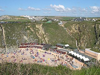
Porth or St Columb Porth is a sea-side village and cove in the civil parish of Newquay, Cornwall, United Kingdom. It was formerly a small shipbuilding port, importing coal from south Wales. The village is to the east of a 1 kilometre (0.62 mi) sandy inlet with the Iron Age promontory fort of Trevelgue Head, on the northern side. A promontory fort is a coastal headland, isolated from the mainland by a stone, turf or earthen rampart(s).
St Dennis Junction was in St Dennis, Cornwall.

Tregatillian is a hamlet immediately east of St. Columb Major in Cornwall, England, United Kingdom. The area is currently the site of a few traditional Cornish houses and a large residential mobile home site, Tregatillian Homes Park.

Quoit is a settlement in mid Cornwall, United Kingdom. It is situated in the parish of St. Columb Major approximately one mile (2 km) southeast of the town of St Columb Major and 7 miles (12 km) east of Newquay. It lies between the A30 dual carriageway trunk road and the A39 road through St Columb Major.
Tregamere is a hamlet in the parish of St Columb Major, Cornwall, England, United Kingdom, about 1 km northeast of the town of St Columb Major.

Trekenning is a hamlet south of St Columb Major, Cornwall, England, United Kingdom.

White Cross is a hamlet in mid Cornwall, England, United Kingdom. It lies on the border between the three parishes of Colan, St Enoder, and St Columb Major. It is on the A392 between Indian Queens and Newquay.
St Columb Major Rural District was a local government division of Cornwall in England, UK, between 1894 and 1934. Established under the Local Government Act 1894, the rural district was abolished in 1934, enlarging Newquay Urban District, Padstow Urban District, St Austell Rural District and Truro Rural District, and creating Wadebridge Rural District.
