
Saint Austell is a town in Cornwall, England, United Kingdom, 10 miles (16 km) south of Bodmin and 30 miles (48 km) west of the border with Devon.

St Erth is a civil parish and village in Cornwall, England, United Kingdom.
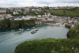
Port Isaac is a small fishing village on the Atlantic coast of north Cornwall, England, in the United Kingdom. The nearest towns are Wadebridge and Camelford, each ten miles (16 km) away. A nearby hamlet, Port Gaverne, is sometimes considered to be part of Port Isaac. The meaning of the village's Cornish name, Porthysek, is "corn port", indicating a trade in corn from the arable inland district.

St Columb Major is a town and civil parish in Cornwall, England, United Kingdom. Often referred to locally as St Columb, it is approximately seven miles (11 km) southwest of Wadebridge and six miles (10 km) east of Newquay The designation Major distinguishes it from the nearby settlement and parish of St Columb Minor on the coast. An electoral ward simply named St Columb exists with a population at the 2011 census of 5,050. The town is named after the 6th-century AD Saint Columba of Cornwall, also known as Columb.
Paul is a village in Cornwall, England, United Kingdom. It is in the civil parish of Penzance. The village is two miles (3 km) south of Penzance and one mile (1.6 km) south of Newlyn.
St Keyne is a village in the civil parish of St Keyne and Trewidland, in east Cornwall, England, United Kingdom. The parish lies between the parishes of Liskeard and Duloe. The parish population at the 2011 census was 492.

Tregony, sometimes in the past Tregoney, is a village and former civil parish, now in the parish of Tregony with Cuby, in Cornwall, England, United Kingdom. It lies on the River Fal. In the village there is a post office, The Kings Arms Pub, shop, a sports and social club and two churches. Tregony has bus links to the nearest city, Truro. Cornelly parish was united with Tregony in 1934. On 1 April 2021 the parish was abolished and merged with Cuby to form "Tregony with Cuby". Tregony was once a port, but clay mining upriver in St Austell has caused the river to become silted over. The population was 768 in 2011 with nearly 15% claiming Cornish identity.

St Buryan is a village and former civil parish, now in the parish of St Buryan, Lamorna and Paul in Cornwall, England, United Kingdom. In 2011 the parish had a population of 1412.
Quethiock is a village and civil parish in Cornwall, England, United Kingdom, roughly five miles east of Liskeard. According to the 2001 census the parish had a population of 429, increasing to 443 at the 2011 census. The ancient parish church of St Hugh is one of the most notable in Cornwall. The placename derives from the Old Cornish cuidoc meaning wooded place. In 1871 the population was 661 and the area 4,351 acres (17.61 km2).

Egloshayle is a civil parish and village in north Cornwall, England, United Kingdom. The village is beside the River Camel, southeast of Wadebridge. The civil parish stretches southeast from the village and includes Washaway and Sladesbridge.

St Mabyn is a civil parish and village in Cornwall, England, United Kingdom. The village is situated three miles (5 km) east of Wadebridge. The parish includes a hamlet called Longstone to the east and many small manor houses, including Tregarden, Tredethy, Helligan Barton and Colquite, all built in the 16th and 17th centuries. The area of the parish is 4,101 acres (16.60 km2).
Delabole is a large village and civil parish in north Cornwall, England, United Kingdom, which lies approximately two miles (3 km) west of Camelford.
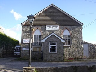
Breage is a village and civil parish in Cornwall, England, United Kingdom. The village is 3 miles (5 km) west of Helston.

Kenwyn is a settlement and civil parish in Cornwall, England, United Kingdom. The settlement is a suburb of the city of Truro and lies 0.5 mi (1 km) north of the city centre, within Truro parish, whereas Kenwyn parish covers an area west and north-west of the city. Kenwyn gives its name to one of three rivers that flow through the city.

St Breward is a civil parish and village in Cornwall, England, United Kingdom. It is on the western side of Bodmin Moor, about 6 miles (10 km) north of Bodmin. At the 2011 census the parish population including Cooksland and Fentonadle was 919.

Dobwalls is a village and civil parish in south-east Cornwall, England, United Kingdom. It is situated 3 mi (5 km) west of Liskeard.
Dobwalls and Trewidland was a civil parish in south-east Cornwall, England, United Kingdom between 1974 and 2021.

St Pinnock is a hamlet and civil parish in southeast Cornwall, England, United Kingdom, 3 miles (5 km) south-west of Liskeard. Other settlements in the parish include East Taphouse, and Penfrane, containing 421 inhabitants. The parish church, dedicated to St Pynnochus (Winnoc), is located at OS Grid Ref SX200630.

Ponsanooth is a village and civil parish in Cornwall, England, United Kingdom. It is about four miles southeast of Redruth and two and a half miles northwest of Penryn on the A393 road Redruth to Falmouth road. In 2019 it had an estimated population of 1184.

Menheniot was an electoral division of Cornwall in the United Kingdom which returned one member to sit on Cornwall Council between 2009 and 2021. It was abolished at the 2021 local elections, being split between the new divisions of Lynher, St Cleer and Menheniot, Looe East and Deviock, and Liskeard South and Dobwalls.

