Trezevant, Tennessee

Last updated

Trezevant, Tennessee
Carroll County Tennessee Incorporated and Unincorporated areas Trezevant Highlighted 4775100.svg
Location of Trezevant in Carroll County, Tennessee.
USA Tennessee location map.svg
Red pog.svg
Trezevant, Tennessee
Location of Trezevant, Tennessee
Coordinates: 36°0′38″N88°37′23″W / 36.01056°N 88.62306°W / 36.01056; -88.62306
Country United States
State Tennessee
County Carroll
Founded1857 [1]
Incorporated1911 [2]
Named for Jim Trezevant, railroad engineer
Government
  MayorBobby J. Blaylock
Area
[3]
  Total1.42 sq mi (3.68 km2)
  Land1.42 sq mi (3.68 km2)
  Water0.00 sq mi (0.00 km2)
Elevation
459 ft (140 m)
Population
 (2020) [4]
  Total799
  Density562.28/sq mi (217.09/km2)
Time zone UTC-6 (Central (CST))
  Summer (DST) UTC-5 (CDT)
ZIP code
38258
Area code 731
FIPS code 47-75100 [5]
GNIS feature ID1304162 [6]
Website http://carrollcounty-tn-chamber.com/index-3.htm

Trezevant is a town in Carroll County, Tennessee. The population was 1,001 at the 2020 census and 959 at the 2010 census.

Contents

Geography

Trezevant is located at 36°0′38″N88°37′23″W / 36.01056°N 88.62306°W / 36.01056; -88.62306 (36.010512, -88.622921). [7]

According to the United States Census Bureau, the town has a total area of 1.4 square miles (3.6 km2), all land.

Demographics

Historical population
CensusPop.Note
1880 327
1920 587
1930 547−6.8%
1940 527−3.7%
1950 76545.2%
1960 94423.4%
1970 877−7.1%
1980 9215.0%
1990 874−5.1%
2000 9013.1%
2010 859−4.7%
2020 799−7.0%
Sources: [8] [9] [4]

As of the census [5] of 2000, there were 901 people, 390 households, and 255 families residing in the town. The population density was 651.0 inhabitants per square mile (251.4/km2). There were 429 housing units at an average density of 310.0 per square mile (119.7/km2). The racial makeup of the town was 85.68% White, 13.32% African American, 0.11% from other races, and 0.89% from two or more races. Hispanic or Latino of any race were 1.66% of the population.

There were 390 households, out of which 27.9% had children under the age of 18 living with them, 48.5% were married couples living together, 11.8% had a female householder with no husband present, and 34.6% were non-families. 31.5% of all households were made up of individuals, and 19.2% had someone living alone who was 65 years of age or older. The average household size was 2.31 and the average family size was 2.90.

In the town, the population was spread out, with 23.0% under the age of 18, 7.0% from 18 to 24, 27.5% from 25 to 44, 22.0% from 45 to 64, and 20.5% who were 65 years of age or older. The median age was 40 years. For every 100 females, there were 89.7 males. For every 100 females age 18 and over, there were 81.2 males.

The median income for a household in the town was $22,045, and the median income for a family was $30,917. Males had a median income of $28,482 versus $18,021 for females. The per capita income for the town was $13,969. About 17.9% of families and 21.1% of the population were below the poverty line, including 27.3% of those under age 18 and 21.8% of those age 65 or over.

Related Research Articles

<span class="mw-page-title-main">Hazel, Kentucky</span> City in Kentucky, United States

Hazel is a home rule-class city in Calloway County, Kentucky, United States. The population was 410 at the 2010 census.

<span class="mw-page-title-main">Clinton, Kentucky</span> City in Kentucky, United States

Clinton is a home rule-class city and the county seat of Hickman County, Kentucky, United States. The population was 1,388 at the 2010 census, a decline from 1,415 in 2000.

<span class="mw-page-title-main">Upton, Maine</span> Town in the state of Maine, United States

Upton is a town in Oxford County, Maine, United States. The population was 69 at the 2020 census.

<span class="mw-page-title-main">Hawthorne, Nevada</span> CDP in Nevada, United States

Hawthorne is a census-designated place (CDP) in Mineral County, Nevada, United States. At the 2010 census, the population was 3,269, a decrease since the 2000 census, when it was 3,311. It is the county seat of Mineral County. The nearby Hawthorne Army Depot is the primary economic base of the town.

West Sparta is a town in Livingston County, New York, United States. The population was 1,255 at the 2010 census. The name is derived from the neighboring town of Sparta.

<span class="mw-page-title-main">Big Sandy, Tennessee</span> Town in Tennessee, United States

Big Sandy is a town in Benton County, Tennessee. The population was 486 at the 2020 census.

<span class="mw-page-title-main">Hollow Rock, Tennessee</span> Town in Tennessee, United States

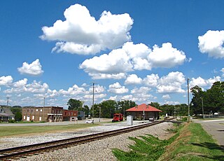
Hollow Rock is a town in Carroll County, Tennessee, United States. The population was 718 at the 2010 census. Hollow Rock is just west of, and adjacent to, the town of Bruceton and is 70 km (43 mi) northeast of Jackson.

<span class="mw-page-title-main">Huntingdon, Tennessee</span> Town in Tennessee, United States

Huntingdon is a town in Carroll County, Tennessee, United States. The population was 4,439 at the 2020 census and 3,985 in 2010. It is the county seat of Carroll County.

<span class="mw-page-title-main">Vanleer, Tennessee</span> Town in Tennessee, United States

Vanleer is a town in Dickson County, Tennessee, United States. The population was estimated to be 422 in 2019, up from 395 at the 2010 census. The town is approximately 49 miles northwest of Nashville and is located within the city's greater metropolitan area.

<span class="mw-page-title-main">Gibson, Tennessee</span> Town in Tennessee, United States

Gibson is a town in Gibson County, Tennessee, United States. The population was 396 at the 2010 census.

<span class="mw-page-title-main">Sardis, Tennessee</span> Town in Tennessee, United States

Sardis is a town in Henderson County, Tennessee, United States. The population was 381 at the 2010 census.

<span class="mw-page-title-main">Cottage Grove, Tennessee</span> Town in Tennessee, United States

Cottage Grove is a town in Henry County, Tennessee, United States. The population was 88 at the 2010 census. Cottage Grove is currently the smallest town in Tennessee.

<span class="mw-page-title-main">Henry, Tennessee</span> Town in Tennessee, United States

Henry is a town in Henry County, Tennessee. The population was 520 at the 2000 census and 464 at the 2010 census, showing decline of 56. Gospel singer Bobby Jones was born here.

<span class="mw-page-title-main">Obion, Tennessee</span> Town in Tennessee, United States

Obion is a town in Obion County, Tennessee, United States, along the Obion River. The population was 1,119 at the 2010 census. It is part of the Union City, TN–KY Micropolitan Statistical Area.

<span class="mw-page-title-main">Dresden, Tennessee</span> Town in Tennessee, United States

Dresden is a town in and the county seat of Weakley County, Tennessee, United States. The population was 3,005 at the 2010 census.

<span class="mw-page-title-main">Gleason, Tennessee</span> Town in Tennessee, United States

Gleason is a town in Weakley County, Tennessee, United States. The population was 1,445 at the 2010 census. The city holds an annual Tater Town Parade and festival in the fall. The girls High School basketball team, the Lady Bulldogs, won the State Championship in 1992, 1999 and 2007.

<span class="mw-page-title-main">Greenfield, Tennessee</span> City in Tennessee, United States

Greenfield is a city in northwestern Weakley County, Tennessee, United States. The population was 2,182 at the 2010 census and 2,078 in 2018.

<span class="mw-page-title-main">Sharon, Tennessee</span> Town in Tennessee, United States

Sharon is a town in Weakley County, Tennessee, United States. The population was 988 at the 2000 census and 944 at the 2010 census.

<span class="mw-page-title-main">Salem, Pierce County, Wisconsin</span> Town in Wisconsin, United States

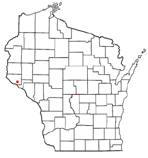
Salem is a town in Pierce County, Wisconsin, United States. The population was 475 at the 2020 census. The unincorporated community of Ono is also located partially in the town.

<span class="mw-page-title-main">Milledgeville, Tennessee</span> Town in Tennessee, United States

Milledgeville is a town in Chester, Hardin, and McNairy counties, Tennessee, United States. The population was 265 at the 2010 census.

References

  1. History of Carroll County, Tennessee , Vol. 1 (Turner Publishing Company, 1987), p. 55.
  2. Tennessee Blue Book , 2005-2006, pp. 618-625.
  3. "ArcGIS REST Services Directory". United States Census Bureau. Retrieved October 15, 2022.
  4. 1 2 "Census Population API". United States Census Bureau. Retrieved October 15, 2022.
  5. 1 2 "U.S. Census website". United States Census Bureau . Retrieved January 31, 2008.
  6. "US Board on Geographic Names". United States Geological Survey. October 25, 2007. Retrieved January 31, 2008.
  7. "US Gazetteer files: 2010, 2000, and 1990". United States Census Bureau. February 12, 2011. Retrieved April 23, 2011.
  8. "Census of Population and Housing: Decennial Censuses". United States Census Bureau . Retrieved March 4, 2012.
  9. "Incorporated Places and Minor Civil Divisions Datasets: Subcounty Resident Population Estimates: April 1, 2010 to July 1, 2012". Population Estimates. U.S. Census Bureau. Archived from the original on June 11, 2013. Retrieved December 11, 2013.