
According to the International Civil Aviation Organization (ICAO), a runway is a "defined rectangular area on a land aerodrome prepared for the landing and takeoff of aircraft". Runways may be a human-made surface or a natural surface. Runways, taxiways and ramps, are sometimes referred to as "tarmac", though very few runways are built using tarmac. Takeoff and landing areas defined on the surface of water for seaplanes are generally referred to as waterways. Runway lengths are now commonly given in meters worldwide, except in North America where feet are commonly used.

McGhee Tyson Airport is a public/military airport 12 miles (19 km) south of Knoxville, in Alcoa, Tennessee. It is named for United States Navy pilot Charles McGhee Tyson, who was killed in World War I.
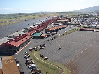
Kahului Airport is the main airport of Maui in the State of Hawaii, United States, located east of Kahului. It has offered full airport operations since 1952. Most flights into Kahului Airport originate from Daniel K. Inouye International Airport in Honolulu; the Honolulu–Kahului corridor is one of the heaviest-trafficked air routes in the US, ranking 13th in 2004 with 1,632,000 passengers.

Molokai Airport, also known as Hoolehua Airport is a state-owned, public use airport located six nautical miles northwest of Kaunakakai, on the island of Molokai in Maui County, Hawaii, United States. It is the principal airport of the island. The largest plane to ever fly here regularly was a Boeing 737-200 jet, which seats 127 passengers.
North Central State Airport is a public use airport in Providence County, Rhode Island, United States. The airport is owned by the State of Rhode Island and opened for service in 1951. It serves the northern portion of the Providence metropolitan area and is located 3 nmi east of the central business district of Smithfield. It is included in the Federal Aviation Administration (FAA) National Plan of Integrated Airport Systems for 2017–2021, in which it is categorized as a local general aviation facility.

New Bedford Regional Airport is a Part 139 Commercial-Service Airport, municipally-owned and available for public use. The airport is located three nautical miles northwest of the City of New Bedford, a city in Bristol County, Massachusetts, United States.

Aspen/Pitkin County Airport, also known as Sardy Field, is a county-owned public-use airport located three nautical miles (6 km) northwest of the central business district of Aspen, in Pitkin County, Colorado, United States. Aspen/Pitkin Co. Airport/Sardy Field covers an area of 573 acres (232 ha) at an elevation of 7,820 feet above mean sea level. It has one asphalt paved runway designated 15/33 which measures 8,006 by 100 feet.
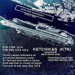
Ketchikan International Airport is a state-owned, public-use airport located one nautical mile (2 km) west of the central business district of Ketchikan, a city in Ketchikan Gateway Borough in Alaska, U.S. state that has no direct road access to the outside world or to the airport. The airport is located on Gravina Island, just west of Ketchikan on the other side of the Tongass Narrows. Passengers must take a seven-minute ferry ride across the water to get to the airport from the town.

Westfield-Barnes Regional Airport is a joint civil-military airport in Hampden County, Massachusetts, three miles (6 km) north of Westfield and northwest of Springfield. It was formerly Barnes Municipal Airport; the National Plan of Integrated Airport Systems for 2011–2015 categorized it as a general aviation facility. Westfield-Barnes is one of Massachusetts' largest airports with a strong flight training, general aviation, and military presence. It is also known as Barnes Air National Guard Base.

Catalina Airport is a privately owned airport located 6.4 miles (10.2 km) northwest of the central business district of Avalon, California, United States, in the middle of Catalina Island. The airport is open to the public and allows general aviation aircraft to land there. The only requirement is that inbound pilots state their intention to land and that they pay a $35 landing fee. The airport is primarily used for general aviation. The airport is also used for airfreight from the mainland. Supplies for the island are delivered daily.

Tom Madsen Airport is a state-owned public-use airport in City of Unalaska, on Amaknak Island in the Aleutian Islands, off the coast of the U.S. state of Alaska. It is located near the Bering Sea coast of Unalaska Island, 800 miles (1,300 km) southwest of Anchorage and 1,950 miles (3,140 km) from Seattle.
Orcas Island Airport is a public airport located 1 nautical mile north of the central business district of Eastsound on Orcas Island in San Juan County, Washington, United States.
Dare County Regional Airport is a public airport located one mile (2 km) northwest of the central business district (CBD) of Manteo, a town in Dare County, North Carolina, United States. This general aviation airport covers 340 acres (138 ha) and has two runways.

Shishmaref Airport is a state-owned public-use airport located one nautical mile (1.85 km) south of the central business district of Shishmaref, a village in the Nome Census Area of the U.S. state of Alaska. It has one asphalt paved runway designated 5/23 and measuring 5,000 x 70 ft.. Shishmaref is located on Sarichef Island in the Chukchi Sea, just north of the Bering Strait and five miles from the mainland.
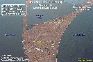
Point Hope Airport is a state-owned public-use airport located two miles (3 km) southwest of the central business district of Point Hope, a city in the North Slope Borough of the U.S. state of Alaska. Point Hope is located in the Lisburne Peninsula, on the Chukchi Sea coast.
Pittsburgh Northeast Airport is a privately owned, public use airport in Allegheny County, Pennsylvania, United States. The airport is located 12 nautical miles north-northeast of the central business district of Pittsburgh, in West Deer Township. The airport is located a few miles north of Pittsburgh Mills shopping mall.

Kulik Lake Airport is a public use airport located one nautical mile (1.85 km) south of Kulik Lake, in the Lake and Peninsula Borough of the U.S. state of Alaska. It is owned by Katmai National Park.
Mackinac County Airport is a county-owned public-use airport in Mackinac County, Michigan, United States. It is located 2 nautical miles northwest of the central business district of St. Ignace. It is the closest airport to Mackinac Island Airport with a refueling station, and is a major stopover destination for flights to and from Mackinac Island that require refueling. The airport is included in the Federal Aviation Administration (FAA) National Plan of Integrated Airport Systems for 2017–2021, in which it is categorized as a local general aviation facility.
Ocracoke Island Airport is a public use airport located one nautical mile (2 km) east of the central business district of Ocracoke, a town on Ocracoke Island in Hyde County, North Carolina, United States. It located in the Cape Hatteras National Seashore, owned by U.S. National Park Service, and operated by the North Carolina Department of Transportation. This airport is included in the National Plan of Integrated Airport Systems for 2011–2015, which categorized it as a general aviation facility.
