
According to the International Civil Aviation Organization (ICAO), a runway is a "defined rectangular area on a land aerodrome prepared for the landing and takeoff of aircraft". Runways may be a human-made surface or a natural surface. Runways, taxiways and ramps, are sometimes referred to as "tarmac", though very few runways are built using tarmac. Takeoff and landing areas defined on the surface of water for seaplanes are generally referred to as waterways. Runway lengths are now commonly given in meters worldwide, except in North America where feet are commonly used.

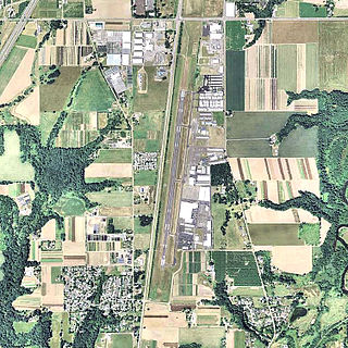
Easterwood Airport is a regional airport in College Station, Texas, with Texas A&M University, Bryan-College Station, and Brazos County, Texas as its communities. Reached from Farm to Market Road 60, it is 3 miles (4.8 km) southwest of the center of College Station, and 0.25 miles (0.40 km) from Texas A&M University. There is no public transportation from Easterwood Airport to the surrounding cities; however, in the fall of 2019, a new university bus route was established to connect Easterwood Airport with the Engineering Quad and the Texas A&M Hotel and Conference Center. The airport bus route is available only to those with a University ID or Brazos Transit District ID. Despite owning and managing the airport, there are no aviation courses at the university.

Southwest Georgia Regional Airport is an airport four miles southwest of Albany, in Dougherty County, Georgia, in the United States. The National Plan of Integrated Airport Systems for 2011–2015 categorized it as a primary commercial service airport. Federal Aviation Administration records say the airport had 39,200 passenger boardings (enplanements) in calendar year 2008, 33,044 in 2009 and 35,494 in 2010.

Page Field is a public airport located in Fort Myers, in Lee County, Florida, United States. It is owned by the Lee County Port Authority; the National Plan of Integrated Airport Systems for 2011–2015 categorized it as a reliever airport.

Merrill Field is a public-use general aviation airport located one mile (1.6 km) east of downtown Anchorage in the U.S. state of Alaska. The airport is owned by Municipality of Anchorage. It opened in 1930 as Anchorage Aviation Field and was renamed in honor of Alaska aviation pioneer Russel Merrill.

Oroville Municipal Airport is a public airport located 3 miles (5 km) southwest of the city of Oroville in Butte County, California, United States.

Tinian International Airport, also known as West Tinian Airport, is a public airport located on Tinian Island in the United States Commonwealth of the Northern Mariana Islands. This airport is owned by Commonwealth Ports Authority.

Arlington Municipal Airport is a public airport located three miles (5 km) southwest of the central business district of Arlington, a city in Snohomish County, Washington, United States. It is owned and operated by the City of Arlington.

John C. Tune Airport is a public airport located in the western portion of the city of Nashville in Davidson County, Tennessee, United States. It is owned by the Metropolitan Nashville Airport Authority, located approximately one mile off of Briley Parkway in the Cockrill Bend area. It is a Class D airport.

Treasure Coast International Airport is a public airport located three miles (5 km) northwest of the central business district of Fort Pierce, a city in St. Lucie County, Florida, United States. It is owned by the St. Lucie Board of County Commissioners.
Aurora State Airport is a public airport located one mile (2 km) northwest of the central business district of Aurora, a city in Marion County, Oregon, United States. It is owned by the Oregon Department of Aviation.
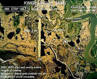
Kwigillingok Airport is owned by the Native Village of Kwigillingok and is a public-use airport located one mile northwest of the central business district of Kwigillingok, in the Bethel Census Area of the U.S. state of Alaska. There is also a nearby seaplane landing area known as Kwigillingok Seaplane Base.

Kissimmee Gateway Airport, formerly known as Kissimmee Municipal Airport, is a public airport in Kissimmee, a city in Osceola County, Florida, United States. The airport is located 16 nautical miles (30 km) southwest of the central business district of Orlando. It is owned and operated by the City of Kissimmee.

Toledo Executive Airport is seven miles southeast of Toledo, in Wood County, Ohio. It is an FAA designated reliever to Toledo Express Airport (TOL), Toledo's primary airport. Toledo Executive Airport was renamed from Metcalf Field in 2010.

Garner Field is an airport in Uvalde County, Texas, three miles east of the city of Uvalde, which owns it. It is named for John Nance Garner, 32nd Vice President of the United States.

Cordova Municipal Airport is a state-owned public-use airport located one nautical mile (1.8 km) east of the central business district of Cordova, a city in the Valdez-Cordova Census Area of the U.S. state of Alaska. It is located on Eyak Lake on which it also has a landing area for seaplanes.
Lowcountry Regional Airport is a public use airport located two nautical miles (4 km) northeast of the central business district of Walterboro, a city in Colleton County, South Carolina, United States. It is owned by the city and county. This airport is included in the National Plan of Integrated Airport Systems for 2011–2015, which categorized it as a general aviation facility. It does not have scheduled commercial airline service.

Everett–Stewart Regional Airport is in Obion County, Tennessee, five miles southeast of Union City, Tennessee, United States. The National Plan of Integrated Airport Systems for 2011–2015 categorized it as a general aviation facility.


