
College Township is a township in Centre County, Pennsylvania. It is part of the State College, Pennsylvania metropolitan statistical area. The population was 10,762 at the 2020 census, which was a 13% increase from the 2010 census. College Township was formed on November 25, 1875, from Howard Township.

Houserville is an unincorporated community and census-designated place (CDP) in Centre County, Pennsylvania, United States. It is part of the State College, Pennsylvania Metropolitan Statistical Area. The population was 1,814 at the 2010 census.
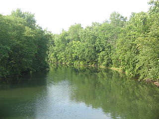
Bald Eagle Creek is a 55.2-mile-long (88.8 km) tributary of the West Branch Susquehanna River mostly in Centre County, Pennsylvania, in the United States.

The Swan's Landing Archeological Site is an archaeological site from the Early Archaic period in Harrison County, Indiana, United States. Located along the Ohio River, it has been extensively damaged by modern activity, but it is still one of the most important sites for its time period in North America. It has been designated a historic site because of its archaeological value.

The Modoc Rock Shelter is a rock shelter or overhang located beneath the sandstone bluffs that form the eastern border of the Mississippi River floodplain at which Native American peoples lived for thousands of years. This site is significant for its archaeological evidence of thousands of years of human habitation during the Archaic period in the Eastern United States. It is located on the northeastern side of County Road 7 southeast of Prairie du Rocher in Randolph County, Illinois, United States. It was declared a National Historic Landmark in 1961.
Hester Site is a major prehistoric archaeological site in Monroe County, Mississippi. It is a multicomponent site whose major occupation took place during the Archaic period with artifacts dating from 9000 to 8000 BCE, and other occupations during the Woodland and Mississippian periods. The site is one of the largest Archaic sites in the southeastern United States, and its well-stratified nature was critical in providing for accurate relative dating of finds at other sites throughout the region. The site was declared a National Historic Landmark in 2001.
Gills Farm Archeological District is a historic district in Randolph, Massachusetts. The district, located in a riverine environment, encompasses a collection of prehistoric archaeological sites dating from the Middle Archaic to the Woodland period. Middle Archaic components include evidence of Neville and Stark projectile points. The quantities of Late Archaic materials found in the area suggest a period of intensive occupation and use. These sites were used as tool workshops, where stone from nearby quarry sites was processed into finished objects, typically bifacial tool blades.
The Memorial Park Site is an archaeological site located near the confluence of Bald Eagle Creek and the West Branch Susquehanna River in Lock Haven in the U.S. state of Pennsylvania. Research projects conducted at the site since 1979 have found prehistoric cultural deposits that collectively span 8,000 years.

The Canfield Island Site, also known as Archeological Site 36LY37, is an archaeological site in Lycoming County, Pennsylvania, United States. Located on Canfield Island in the West Branch Susquehanna River, the site lies east of the city of Williamsport in Loyalsock Township. It is believed to have been inhabited by prehistoric Native Americans for thousands of years, with the oldest discoveries dating back to more than one millennium before Christ.

The Sommerheim Park Archaeological District includes a group of six archaeological sites west of Erie, Pennsylvania in the United States. The sites are in Sommerheim Park, one of the few undeveloped areas of the Lake Erie shoreline, in Millcreek Township. This district has been listed on the National Register of Historic Places. This is one of the leading archaeological sites in the Erie area and along the southern shoreline of Lake Erie, due to the amount of artifacts and the lack of disturbance on the site.

The Fisher Farm site is an archaeological site in Centre County, Pennsylvania, United States. Located in fields on the outskirts of Unionville, it is one of central Pennsylvania's leading archaeological sites.

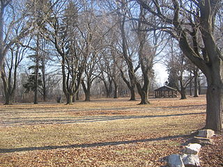
The Houserville Site is an archaeological site located near State College in Centre County, Pennsylvania, United States. Used as a stone workshop by prehistoric Native Americans ten thousand years ago, it has been recognized as a prime candidate for prehistoric preservation.

The LoDaisKa site is a prominent archaeological site in the U.S. state of Colorado, located within a rockshelter near Morrison. The rockshelter was first inhabited by people of the Archaic through the Middle Ceramic period, generally spanning 3000 BC to 1000 AD.

Roxborough State Park Archaeological District is located in Douglas County, Colorado. Roxborough State Park, 25 miles (40 km) south of Denver, Colorado, is a Colorado State Park day park. Archaeological artifacts reflect that there were prehistoric hunter-gatherers who lived or camped, made tools from stone quarries, and farmed in the Roxborough State Park area.

The Juntunen site, also known as 20MK1, is a stratified prehistoric Late Woodland fishing village located on the western tip of Bois Blanc Island. It was listed on the National Register of Historic Places in 1978.
The Carlston Annis Shell Mound is a prominent archaeological site in the western part of the U.S. state of Kentucky. Located along the Green River in Butler County, this shell midden has been declared a historic site because of its archaeological value.
Ntolonapemk, also known as the Eastern Surplus Company Superfund Site and Maine State Survey No. 96.02, is a prehistoric archaeological site in Meddybemps, a small town in Washington County, Maine. Located near the outlet of Meddybemps Lake, it is one of the only major inland prehistoric habitation sites in the county, with evidence of more than 8,000 years of use. The site was listed on the National Register of Historic Places in 2001.
The Two Dogs Site is a lithic quarry site located in Person County, North Carolina. This prehistoric archaeological site dates to the Middle Archaic and Woodland Periods, and it is classified as a lithic quarry site due to the presence of thousands of lithic artifacts found there. Located in the Carolina Slate Belt, the stone materials present at Two Dogs provided prehistoric peoples with openly accessible lithic resources, predominantly for tool-making, as they passed through the site between other, more residential areas. Two Dogs was excavated from 2004-2005 following shovel testing at the beginning of the decade. The lithic materials found at the Two Dogs Site were subjected to petrographic analysis, and isotopes were geochemically tested to confirm the origins of the stone artifacts. The Two Dogs site has been determined to be neither residential or agricultural; rather, this site was exclusively an area where people from nearby sedentary civilizations could access their necessary lithic resources.


