Tull, Arkansas | |
---|---|
Coordinates: 34°26′47″N92°34′53″W / 34.44639°N 92.58139°W | |
Country | United States |
State | Arkansas |
County | Grant |
Area | |
• Total | 4.10 sq mi (10.61 km2) |
• Land | 4.03 sq mi (10.44 km2) |
• Water | 0.07 sq mi (0.17 km2) |
Elevation | 351 ft (107 m) |
Population (2020) | |
• Total | 484 |
• Density | 120.04/sq mi (46.35/km2) |
Time zone | UTC-6 (Central (CST)) |
• Summer (DST) | UTC-5 (CDT) |
FIPS code | 05-70220 |
GNIS feature ID | 0055693 |
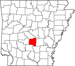
Tull is a town in Grant County, Arkansas, United States. The population was 448 at the 2010 census, [2] up from 358 in 2000. It is part of the Central Arkansas region.
Tull is located in northwestern Grant County at 34°26′47″N92°34′53″W / 34.44639°N 92.58139°W (34.446405, -92.581518). [3] It is bordered to the north and northwest by the Saline County line. The northwest border of the town follows the Saline River, a south-flowing tributary of the Ouachita River. Tull is 16 miles (26 km) northwest of Sheridan, the Grant County seat, and 10 miles (16 km) south of Benton.
According to the United States Census Bureau, the town has a total area of 3.4 square miles (8.9 km2), of which 0.02 square miles (0.04 km2), or 0.40%, is water. [2]
Census | Pop. | Note | %± |
---|---|---|---|
1970 | 179 | — | |
1980 | 281 | 57.0% | |
1990 | 313 | 11.4% | |
2000 | 358 | 14.4% | |
2010 | 448 | 25.1% | |
2020 | 484 | 8.0% | |
U.S. Decennial Census [4] |
As of the census [5] of 2000, there were 358 people, 155 households, and 110 families residing in the town. The population density was 40.4/km2 (104.6/mi2). There were 167 housing units at an average density of 18.9/km2 (48.8/mi2). The racial makeup of the town was 99.16% White, 0.56% Native American, and 0.28% from two or more races. 3.07% of the population were Hispanic or Latino of any race.
There were 155 households, out of which 26.5% had children under the age of 18 living with them, 64.5% were married couples living together, 3.9% had a female householder with no husband present, and 29.0% were non-families. 27.1% of all households were made up of individuals, and 20.0% had someone living alone who was 65 years of age or older. The average household size was 2.31 and the average family size was 2.81.
In the town, the population was spread out, with 19.0% under the age of 18, 7.8% from 18 to 24, 27.9% from 25 to 44, 29.1% from 45 to 64, and 16.2% who were 65 years of age or older. The median age was 43 years. For every 100 females, there were 101.1 males. For every 100 females age 18 and over, there were 93.3 males.
The median income for a household in the town was $33,750, and the median income for a family was $41,406. Males had a median income of $30,417 versus $29,250 for females. The per capita income for the town was $18,017. About 10.1% of families and 10.7% of the population were below the poverty line, including 14.1% of those under age 18 and 7.8% of those age 65 or over.
Tull is in the Bauxite School District, [6] and is zoned to Bauxite High School.
Saline County is located in the U.S. state of Arkansas. As of the 2020 census, the population was 123,416. Its county seat and largest city is Benton. Saline County was formed on November 2, 1835, and named for the salt water (brine) springs in the area, despite a differing pronunciation from saline. Until November 2014, it was an alcohol prohibition or dry county.
Grant County is a county in the U.S. state of Arkansas. Its population was 17,958 at the 2020 United States Census. The county seat is Sheridan.
Hermitage is a city in Bradley County, Arkansas, United States. The United States Census Bureau estimated the population to be 830 as of the 2010 census.
Oak Grove is a town in Carroll County, Arkansas, United States. The population was 386 at the 2020 census.
Higden is a town in Cleburne County, Arkansas, United States. The population was 120 at the 2010 census. Scott Barker is the current Mayor of Higden
Menifee is a town in Conway County, Arkansas, United States. The population was 302 at the 2010 census.
Horseshoe Lake is a town in Crittenden County, Arkansas, United States. The population was 264 at the 2020 census.
Enola is a town in Faulkner County, Arkansas, United States. It is part of the Central Arkansas region. The population was 318 at the 2020 census.
Perla is a town in Hot Spring County, Arkansas, United States. The population was 241 at the 2010 census, up from 115 at the 2000 census. The city's water association filed for Chapter 9 Bankruptcy in the Western District of Arkansas Bankruptcy Court on May 26, 2019.
Minturn is a town in Lawrence County, Arkansas, United States. The population was 109 at the 2010 census.
Aubrey is a town in Lee County, Arkansas, United States. The population was 108 at the 2020 census.
Allport is a town in Lonoke County, Arkansas, United States. Although a black enclave in the largely-white Lonoke County since the 1870s, the town did not incorporate until 1967 in order to receive funding for municipal services. Located within Central Arkansas along Highway 165, the community's economy is strongly tied to agriculture. The population was 115 at the 2010 Census.
Dell is a town in Mississippi County, Arkansas, United States. The population was 194 at the 2020 census.
Roe is a town in Monroe County, Arkansas, United States. Located at the junction of U.S. Route 79 and Arkansas Highway 33, the population was 68 at the 2020 census, down from 114 in 2010.
Fourche is a town in Perry County, Arkansas, United States. The population was 59 at the 2000 census. It is part of the Little Rock–North Little Rock–Conway Metropolitan Statistical Area.
Alexander is a city in Pulaski and Saline counties in the U.S. state of Arkansas. Located in Central Arkansas, the town was founded as a construction camp for the nearby railroad. Following its completion, the citizens decided to incorporate in 1887. Alexander is home to the Arkansas Juvenile Assessment and Treatment Center. The population was 2,901 at the 2010 census.
Bauxite is a city in Saline County, Arkansas, United States. Located within Central Arkansas, the city is named for bauxite, the source ore for aluminum, which was found in abundant quantities in the area and became a source of aluminium refining. The city's population boomed during expanded aluminium production during World War II and shrank rapidly with output of the ore. Bauxite was incorporated as a town in 1973. The population was 487 at the 2010 census.
Bryant is a city in Saline County, Arkansas, United States and a suburb of Little Rock. According to the 2010 Census, the population of the city was 16,688. It is part of the Central Arkansas region.
East End is a census-designated place (CDP) in Saline County, Arkansas, United States. The population was 6,998 at the 2010 census. It is part of the Little Rock–North Little Rock–Conway Metropolitan Statistical Area.
Traskwood is a city in Saline County, Arkansas, United States. The population was 518 at the 2010 census. It is part of the Little Rock–North Little Rock–Conway Metropolitan Statistical Area.