Prattsville, Arkansas

Last updated

Prattsville, Arkansas
Prattsville Sign.jpg
Grant County Arkansas Incorporated and Unincorporated areas Prattsville Highlighted 0557230.svg
Location of Prattsville in Grant County, Arkansas.
Coordinates: 34°19′02″N92°32′34″W / 34.31722°N 92.54278°W / 34.31722; -92.54278
Country United States
State Arkansas
County Grant
Area
[1]
  Total1.62 sq mi (4.21 km2)
  Land1.62 sq mi (4.19 km2)
  Water0.01 sq mi (0.02 km2)
Elevation
[2]
312 ft (95 m)
Population
 (2020)
  Total289
  Density178.73/sq mi (68.99/km2)
Time zone UTC-6 (Central (CST))
  Summer (DST) UTC-5 (CDT)
ZIP code
72129
Area code 870
FIPS code 05-57230
GNIS feature ID2407158 [2]

Prattsville is a city [3] in Grant County, Arkansas, United States. The population was 305 at the 2010 census. It is part of the Central Arkansas region.

Contents

Geography

According to the United States Census Bureau, the city has a total area of 4.3 km2 (1.7 mi2), all land.

Demographics

Historical population
CensusPop.Note
1970 299
1980 3176.0%
1990 251−20.8%
2000 28212.4%
2010 3058.2%
2020 289−5.2%
U.S. Decennial Census [4]

As of the census of 2000, there were 282 people, 115 households, and 83 families residing in the town. The population density was 66.0/km2 (170.6/mi2). There were 128 housing units at an average density of 30.0/km2 (77.4/mi2). The racial makeup of the town was 99.65% White and 0.35% Asian. Hispanic or Latino of any race were 0.35% of the population.

There were 115 households, out of which 33.0% had children under the age of 18 living with them, 61.7% were married couples living together, 9.6% had a female householder with no husband present, and 27.0% were non-families. 26.1% of all households were made up of individuals, and 17.4% had someone living alone who was 65 years of age or older. The average household size was 2.45 and the average family size was 2.95.

In the town, the population was spread out, with 23.8% under the age of 18, 7.4% from 18 to 24, 27.0% from 25 to 44, 25.9% from 45 to 64, and 16.0% who were 65 years of age or older. The median age was 37 years. For every 100 females, there were 101.4 males. For every 100 females age 18 and over, there were 90.3 males.

The median income for a household in the town was $42,679, and the median income for a family was $47,500. Males had a median income of $30,000 versus $19,000 for females. The per capita income for the town was $17,544. About 9.8% of families and 12.5% of the population were below the poverty line, including 19.1% of those under the age of eighteen and 20.4% of those 65 or over.

History

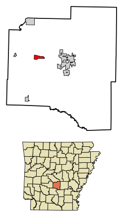
Prattsville, then part of Saline County, was first settled by Elder Joab Pratt, a Baptist preacher, accompanied by several other families, with the surnames of Mayfield, Pumphrey, McDaniel, and Cobb, all arrived by wagon train from Bibb County, Alabama in 1841. Mr. Pratt is the source of the town's name. Mr. Pratt operated Pratt's Ferry close to where modern day Highway 270 crosses the Saline River and served as the postmaster for Lost Creek Post Office in 1846. [5] Mr. Pratt founded Philadelphia Baptist Church soon after settling in the area south of the modern day city limits.

A section of the pre-statehood wagon road, the Old Camden Trail, was a highly traveled road throughout the nineteenth century that connected Little Rock and Camden. The Old Camden Trail was one of only five main roads in Arkansas during the 1800s and served early settlers of Prattsville. It is still marked on current maps in the town and has a historical marker north of Prattsville in the pioneer Village of Belfast, unfortunately the historic road has been gated and access to the marker blocked. [6] During the Civil War, as part of Gen. Frederick Steele's Camden expedition, part of the larger Red River Campaign, attempted to cross the Saline River at Pratt's Ferry with his troops to get his nearly supply-less Union Army back to Little Rock along the Old Camden Road, however the water there was too high, and Gen. Steele and his troops turned south to cross at Jenkins Ferry, where his Union Army were engaged by Confederate Troops in what is called the Battle of Jenkins Ferry. [7] Gen. Steele's Camden expedition cost the Union army countless men and badly needed supplies. [8] Gen. Steele and the Union Army escaped and made a retreat back to Little Rock along the Old Camden Trail. [9] [10]

Education

The Sheridan School District operates area public schools. The Prattsville School District merged into the Sheridan district on July 1, 1994. [11]

Notable Prattsvillians

David Delano Glover (January 18, 1868 – April 5, 1952) was born and attended public school in Prattsville. He was a U.S. Representative from Arkansas. He served six terms from March 4, 1929, to January 3, 1935. He was admitted to the bar in 1910. [12]

Robert W. Glover, David Delano Glover's brother and a Missionary Baptist pastor, served in both houses of the Arkansas Legislature (1905–1912) from Sheridan. He lived briefly as a child in Prattsville. In 1909, he introduced the resolution calling for the establishment of four state agricultural colleges. [13]

Jackson T. Stephens (1923–2005), born on a farm near Prattsville during the Great Depression, co-founded Stephens, Inc., the largest trading company outside of Wall Street, located in Little Rock. He donated millions of dollars to worthy causes, including the University of Arkansas for Medical Sciences campus, the Delta Project, the U.S. Naval Academy, where he graduated with classmate Jimmy Carter, [14] First Tee of Arkansas, the Prattsville Community Center, and others. His personal art collection, of which he donated a portion of to the Arkansas Arts Center, has been recognized[ citation needed ] as one of the most important art collections in the country. He served as chairman of the Augusta National Golf Club, overseeing The Masters golf tournament. He is interred at Philadelphia Cemetery in Prattsville. [15]

Wilton "Witt" R. Stephens (1907–1991) was born in Prattsville and was the older brother of Jack Stephens. He began his career selling belt buckles and Bibles door to door in the late 1920s. During the Great Depression, Witt purchased municipal bonds for ten cents on the dollar, confident that the bonds would be redeemable under President Franklin D. Roosevelt's Reconstruction Finance Corporation. He sold the bonds at a profit to make a small fortune in the worst economic climate in American history. He went on to invest in natural gas, oil, and gold mining industries. After World War II, he was known as the "kingmaker" due to his influential power over the state's political branches. He served two terms in his father's State House seat starting in 1961. [14] The Grant County Museum building is named in his honor. He is interred in Philadelphia Cemetery in Prattsville. [16]

Ray Thornton (1928–) was a resident of Prattsville and is the nephew of Jack and Witt Stephens. Thornton is a former U.S. Representative, lawyer, Arkansas Supreme Court justice, university president, and currently is the Public Service Fellow for the University of Arkansas at Little Rock William H. Bowen School of Law. [17] Thornton played "a key role in fashioning the articles of impeachment against President Richard Nixon concerning the Watergate cover-up." [18] Thornton was a party in the Supreme Court of the United States case, U.S. Term Limits, Inc. v. Thornton , [19] which ruled Arkansas's and other states' attempts at placing term limits on members of the U.S. House of Representatives and the U.S. Senate unconstitutional. [18]

Related Research Articles

<span class="mw-page-title-main">Grant County, Arkansas</span> County in Arkansas, United States

Grant County is a county in the U.S. state of Arkansas. Its population was 17,958 at the 2020 United States Census. The county seat is Sheridan.

<span class="mw-page-title-main">Cleveland County, Arkansas</span> County in Arkansas, United States

Cleveland County is a county located in the U.S. state of Arkansas. Its population was 7,550 at the 2020 U.S. census. The county seat and largest city is Rison.

<span class="mw-page-title-main">Almyra, Arkansas</span> Town in Arkansas, United States

Almyra is a town in Arkansas County, Arkansas, United States. The population was 283 at the 2010 census.

<span class="mw-page-title-main">St. Charles, Arkansas</span> Town in Arkansas, United States

St. Charles is a town in Arkansas County, Arkansas, United States. The population was 230 at the 2010 census. The small town has been at the center of various events in Arkansas' history. St. Charles is best known for the Battle of Saint Charles, which was fought on the White River, which borders the town. St. Charles is also known for being in the White River National Wildlife Refuge.

<span class="mw-page-title-main">Hermitage, Arkansas</span> City in Arkansas, United States

Hermitage is a city in Bradley County, Arkansas, United States. The United States Census Bureau estimated the population to be 830 as of the 2010 census.

<span class="mw-page-title-main">Blue Eye, Arkansas</span> Town in Arkansas, United States

Blue Eye is an incorporated town in Carroll County, Arkansas, United States. The population was 46 at the 2020 census. The population estimate is 32 as of 2022. Blue Eye, Arkansas, is adjacent to Blue Eye, Missouri.

<span class="mw-page-title-main">Okolona, Arkansas</span> Town in Arkansas, United States

Okolona is a town near the western edge of Clark County, Arkansas, United States. The population was 147 at the 2010 census.

<span class="mw-page-title-main">Higden, Arkansas</span> Town in Arkansas, United States

Higden is a town in Cleburne County, Arkansas, United States. The population was 120 at the 2010 census. Scott Barker is the current Mayor of Higden

<span class="mw-page-title-main">Leola, Arkansas</span> Town in Arkansas, United States

Leola is a town in Grant County, Arkansas, United States. The population was 501 at the 2010 census. It is the southernmost municipality within the Central Arkansas region.

<span class="mw-page-title-main">Sheridan, Arkansas</span> City in Arkansas, United States

Sheridan is a city and county seat of Grant County, Arkansas, United States. The community is located deep in the forests of the Arkansas Timberlands. It sits at the intersection of US Highways 167 and 270. Early settlers were drawn to the area by the native timber, which is still a very important part of Sheridan's economy, although the city has diversified into several other industries. Sheridan's history also includes a college, Missionary Baptist College, until its closure in 1934, and a series of conflicts during the Civil Rights Movement. Located at the southern end of the Central Arkansas region, Sheridan has been experiencing a population boom in recent years, as indicated by a 49% growth in population between the 1990 and 2010 censuses. The population as of the 2010 census was 4,603.

<span class="mw-page-title-main">Tull, Arkansas</span> Town in Arkansas, United States

Tull is a town in Grant County, Arkansas, United States. The population was 448 at the 2010 census, up from 358 in 2000. It is part of the Central Arkansas region.

<span class="mw-page-title-main">Black Springs, Arkansas</span> Town in Arkansas, United States

Black Springs is a town in Montgomery County, Arkansas, United States. The population was 96 at the 2020 census.

<span class="mw-page-title-main">Camden, Arkansas</span> City in Arkansas, United States

Camden is a city in and the county seat of Ouachita County in the south-central part of the U.S. state of Arkansas. The city is located about 100 miles south of Little Rock. Situated on bluffs overlooking the Ouachita River, the city developed because of the river.

<span class="mw-page-title-main">East Camden, Arkansas</span> City in Arkansas, United States

East Camden is a city in Ouachita County, Arkansas, United States. The population was 931 at the 2010 census. It is part of the Camden Micropolitan Statistical Area. East Camden was originally called Billkitts Rental Housing and began as a planned community created to support the nearby Shumaker Naval Ammunition Depot.

<span class="mw-page-title-main">Fourche, Arkansas</span> Town in Arkansas, United States

Fourche is a town in Perry County, Arkansas, United States. The population was 59 at the 2000 census. It is part of the Little Rock–North Little Rock–Conway Metropolitan Statistical Area.

<span class="mw-page-title-main">DeValls Bluff, Arkansas</span> City in Arkansas, United States

DeValls Bluff is a city in and the county seat of the southern district of Prairie County, Arkansas, United States. The population was 619 at the 2010 census.

<span class="mw-page-title-main">Traskwood, Arkansas</span> City in Arkansas, United States

Traskwood is a city in Saline County, Arkansas, United States. The population was 518 at the 2010 census. It is part of the Little Rock–North Little Rock–Conway Metropolitan Statistical Area.

<span class="mw-page-title-main">Prattsville (town), New York</span> Town in New York, United States

Prattsville is a town in Greene County, New York, United States. The town is in the northwestern part of the county. As of the 2020 census, the population was 774.

The Battle of Jenkins' Ferry, also known as the Engagement at Jenkins' Ferry, was fought on April 30, 1864, at Jenkins' Ferry, southwest of Little Rock, during the American Civil War. Although the battle ended with a Union victory, the Confederates saw it as a strategic success as they claimed to have prevented Frederick Steele from holding southwest Arkansas. Due to the chaotic nature of the battle, casualty figures vary.

The Camden Expedition was the final campaign conducted by the Union Army in Arkansas during the Civil War. The offensive was designed to cooperate with Major-General Nathaniel P. Banks' movement against Shreveport.

References

  1. "2020 U.S. Gazetteer Files". United States Census Bureau. Retrieved October 29, 2021.
  2. 1 2 U.S. Geological Survey Geographic Names Information System: Prattsville, Arkansas
  3. Local.Arkansas.gov - Prattsville , retrieved September 3, 2012
  4. "Census of Population and Housing". Census.gov. Retrieved June 4, 2015.
  5. Crowson, Robert L. (July 1988). "From Alabama to Arkansas An 1841 Journey". Grassroots Journal of the Grant County Museum. Retrieved June 3, 2012.]
  6. "Encyclopedia of Arkansas".
  7. "Encyclopedia of Arkansas".
  8. Arkansas History Commission, "Documenting Arkansas: The Civil War 1861-1865," pg. 78-83. (2012)
  9. "Encyclopedia of Arkansas".
  10. Lancaster, Jim. "Crossing Saline River at Jenkin's Ferry" . Retrieved June 3, 2012.
  11. "ConsolidationAnnex_from_1983.xls Archived 2015-09-12 at the Wayback Machine ." Arkansas Department of Education. Retrieved on October 13, 2017.
  12. "Encyclopedia of Arkansas".
  13. "ASU-Jonesboro: Act 100 Re-enactment Ceremony". astate.edu. Archived from the original on January 16, 2011. Retrieved July 5, 2011.
  14. 1 2 "Arkansas Business 20th Anniversary". www.arkansasbusiness.com. Archived from the original on April 21, 2004.
  15. "Obituary Notice - Jackson T. "Jack" Stephens".
  16. "Encyclopedia of Arkansas".
  17. "UALR Law - Congressman Ray Thornton - University of Arkansas at Little Rock William H. Bowen School of Law". Archived from the original on October 10, 2010. Retrieved June 4, 2012.
  18. 1 2 "Encyclopedia of Arkansas".
  19. 514 U.S. 779 (1995); https://www.law.cornell.edu/supct/html/93-1456.ZO.html