Tupelo, Arkansas

Last updated

Tupelo, Arkansas
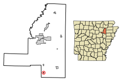
Jackson County Arkansas Incorporated and Unincorporated areas Tupelo Highlighted 0570340.svg
Location of Tupelo in Jackson County, Arkansas.
Coordinates: 35°23′25″N91°13′48″W / 35.39028°N 91.23000°W / 35.39028; -91.23000
Country United States
State Arkansas
County Jackson
Area
[1]
  Total
0.28 sq mi (0.72 km2)
  Land0.28 sq mi (0.72 km2)
  Water0.00 sq mi (0.00 km2)
Elevation
[2]
213 ft (65 m)
Population
 (2020)
  Total
70
  Density251.80/sq mi (97.34/km2)
Time zone UTC-6 (Central (CST))
  Summer (DST) UTC-5 (CDT)
ZIP code
72169
Area code 870
FIPS code 05-70340
GNIS feature ID2406765 [2]

Tupelo is a town in Jackson County, Arkansas, United States. The population was 180 at the 2010 census. [3]

Contents

Geography

According to the United States Census Bureau, the town has a total area of 0.31 square miles (0.8 km2), all land.

Demographics

Historical population
CensusPop.Note
1910 205
1920 31754.6%
1930 264−16.7%
1940 249−5.7%
1950 188−24.5%
1960 2016.9%
1970 24622.4%
1980 2480.8%
1990 208−16.1%
2000 177−14.9%
2010 1801.7%
2020 70−61.1%
U.S. Decennial Census [4]

As of the census [5] of 2000, there were 177 people, 76 households, and 50 families residing in the town. The population density was 220.5/km2 (568.5/mi2). There were 93 housing units at an average density of 115.8/km2 (298.7/mi2). The racial makeup of the town was 99.44% White, 0.56% from other races. 1.69% of the population were Hispanic or Latino of any race.

There were 76 households, out of which 22.4% had children under the age of 18 living with them, 55.3% were married couples living together, 6.6% had a female householder with no husband present, and 32.9% were non-families. 27.6% of all households were made up of individuals, and 15.8% had someone living alone who was 65 years of age or older. The average household size was 2.33 and the average family size was 2.80.

In the town, the population was spread out, with 22.0% under the age of 18, 6.2% from 18 to 24, 29.9% from 25 to 44, 23.7% from 45 to 64, and 18.1% who were 65 years of age or older. The median age was 37 years. For every 100 females, there were 96.7 males. For every 100 females age 18 and over, there were 100.0 males.

The median income for a household in the town was $27,614, and the median income for a family was $28,750. Males had a median income of $24,375 versus $14,750 for females. The per capita income for the town was $12,301. About 13.3% of families and 23.4% of the population were below the poverty line, including 26.1% of those under the age of 18 and 25.0% of those 65 or over.

Education

It is in the Newport School District. [6]

Related Research Articles

<span class="mw-page-title-main">South Lead Hill, Arkansas</span> Town in Arkansas, United States

South Lead Hill is a town in Boone County, Arkansas, United States. The population was 102 at the 2010 census. It is part of the Harrison Micropolitan Statistical Area.

<span class="mw-page-title-main">Valley Springs, Arkansas</span> Town in Arkansas, United States

Valley Springs is a town in Boone County, Arkansas, United States. The population was 175 at the 2010 census. It is part of the Harrison Micropolitan Statistical Area.

<span class="mw-page-title-main">Whelen Springs, Arkansas</span> Town in Arkansas, United States

Whelen Springs is a town in Clark County, Arkansas, United States. The population was 92 at the 2010 census. From 1930 through 1939 the town thrived, being a main hub of operations for the then powerful Ozan Lumber Company.

<span class="mw-page-title-main">McDougal, Arkansas</span> City in Arkansas, United States

McDougal is a city in Clay County, Arkansas, United States. The population was 186 at the 2010 census.

<span class="mw-page-title-main">Winchester, Arkansas</span> Town in Arkansas, United States

Winchester is a small town in northeast Drew County, Arkansas, United States. The population was 167 at the 2010 census, declining from its 20th-century high of 279 in 1980.

<span class="mw-page-title-main">Tull, Arkansas</span> Town in Arkansas, United States

Tull is a town in Grant County, Arkansas, United States. The population was 448 at the 2010 census, up from 358 in 2000. It is part of the Central Arkansas region.

<span class="mw-page-title-main">Moorefield, Arkansas</span> Town in Arkansas, United States

Moorefield is a town in Independence County, Arkansas, United States. It was named after Jesse A. Moore who owned most of the land in the area of the town at that time. The population was 137 at the 2010 census.

<span class="mw-page-title-main">Sulphur Rock, Arkansas</span> Town in Arkansas, United States

Sulphur Rock is a town in Independence County, Arkansas, United States. The population was 456 at the 2010 census.

<span class="mw-page-title-main">Minturn, Arkansas</span> Town in Arkansas, United States

Minturn is a town in Lawrence County, Arkansas, United States. The population was 109 at the 2010 census.

<span class="mw-page-title-main">Moro, Arkansas</span> Town in Arkansas, United States

Moro is a town in Lee County, Arkansas, United States. The population was 216 at the 2010 census.

<span class="mw-page-title-main">Rosston, Arkansas</span> Town in Arkansas, United States

Rosston is a town in south-central Nevada County, Arkansas, United States. The population was 265 at the 2000 census. It is part of the Hope Micropolitan Statistical Area.

<span class="mw-page-title-main">Western Grove, Arkansas</span> Town in Arkansas, United States

Western Grove is a town in northeastern Newton County, Arkansas, United States. The population was 384 at the 2010 census. It is part of the Harrison Micropolitan Statistical Area.

<span class="mw-page-title-main">Adona, Arkansas</span> City in Arkansas, United States

Adona is a city in Perry County, Arkansas, United States. The population was 209 at the 2010 census.

<span class="mw-page-title-main">Perry, Arkansas</span> Town in Arkansas, United States

Perry is a town in Perry County, Arkansas, United States. The population was 314 at the 2000 census. It is part of the Little Rock–North Little Rock–Conway Metropolitan Statistical Area.

<span class="mw-page-title-main">Traskwood, Arkansas</span> City in Arkansas, United States

Traskwood is a city in Saline County, Arkansas, United States. The population was 518 at the 2010 census. It is part of the Little Rock–North Little Rock–Conway Metropolitan Statistical Area.

<span class="mw-page-title-main">Midland, Arkansas</span> Town in Sebastian County, Arkansas, United States

Midland is a town in Sebastian County, Arkansas, United States. It is part of the Fort Smith, Arkansas-Oklahoma Metropolitan Statistical Area. The population was 325 at the 2010 census.

<span class="mw-page-title-main">Widener, Arkansas</span> Town in Arkansas, United States

Widener is a town in St. Francis County, Arkansas, United States. The population was 212 at the 2020 census, a decline from 273 in 2010.

<span class="mw-page-title-main">Goshen, Arkansas</span> City in Arkansas, United States

Goshen is a city in Washington County, Arkansas, United States. The population was 2,102 at the 2020 census. It is part of the Northwest Arkansas region. According to Business Insider, it is the “most educated” city in the state of Arkansas.

<span class="mw-page-title-main">Russell, Arkansas</span> Town in Arkansas, United States

Russell is a town in White County, Arkansas, United States. The population was 228 at the 2000 census.

<span class="mw-page-title-main">West Point, Arkansas</span> Town in Arkansas, United States

West Point is a town in White County, Arkansas, United States.

References

  1. "2020 U.S. Gazetteer Files". United States Census Bureau. Retrieved October 29, 2021.
  2. 1 2 U.S. Geological Survey Geographic Names Information System: Tupelo, Arkansas
  3. "Geographic Identifiers: 2010 Demographic Profile Data (G001): Tupelo town, Arkansas". U.S. Census Bureau, American Factfinder. Archived from the original on February 12, 2020. Retrieved January 14, 2013.
  4. "Census of Population and Housing". Census.gov. Retrieved June 4, 2015.
  5. "U.S. Census website". United States Census Bureau . Retrieved January 31, 2008.
  6. "SCHOOL DISTRICT REFERENCE MAP (2010 CENSUS): Jackson County, AR" (PDF). U.S. Census Bureau . Retrieved March 4, 2021.