Turriers

Last updated • 4 min readFrom Wikipedia, The Free Encyclopedia

Turriers
Turriers-18.JPG
The church and surrounding buildings in Turriers
Blason Turriers.svg
Location of Turriers
Turriers
France location map-Regions and departements-2016.svg
Red pog.svg
Turriers
Provence-Alpes-Cotes d'Azur region location map.svg
Red pog.svg
Turriers
Coordinates: 44°24′08″N6°10′11″E / 44.4022°N 6.1697°E / 44.4022; 6.1697
Country France
Region Provence-Alpes-Côte d'Azur
Department Alpes-de-Haute-Provence
Arrondissement Forcalquier
Canton Seyne
Government
  Mayor (20202026) Jean-Yves Sigaud [1]
Area
1
19.86 km2 (7.67 sq mi)
Population
 (2021) [2]
344
  Density17/km2 (45/sq mi)
Time zone UTC+01:00 (CET)
  Summer (DST) UTC+02:00 (CEST)
INSEE/Postal code
04222 /04250
Elevation853–1,714 m (2,799–5,623 ft)
(avg. 1,040 m or 3,410 ft)
1 French Land Register data, which excludes lakes, ponds, glaciers > 1 km2 (0.386 sq mi or 247 acres) and river estuaries.

Turriers (French pronunciation: [tyʁje] ) is a commune in the Alpes-de-Haute-Provence department in southeastern France.

Contents

Population

Historical population
YearPop.±% p.a.
1968 230    
1975 226−0.25%
1982 286+3.42%
1990 276−0.44%
1999 297+0.82%
2009 388+2.71%
2014 339−2.66%
2020 343+0.20%
Source: INSEE [3]

Geography

The village is situated at an altitude of 1,040 meters on a rocky promontory called "Les Baumelles". It presents the classic aspect of an Haute Provence hilltop village. Turriers has long been a farming community, along with its surrounding hamlets, and is the focal point of a vast basin of meadow and farmland topped by forest. The ancient farming activities are still in evidence. The meadows are enclosed by a spectacular circle of hills rising up to 850 m above Turriers. To the north, there are clear views of the High Alps.

Turriers is approached from Sisteron or Gap by the routes D951 and D1; from the east by the D1 from Seyne Alpes; from the south by the D5 from Bayons. Other communes located near Turriers are Bellaffaire, Saint-Martin-lès-Seyne, Bayons, Faucon-du-Caire, and Gigors.

Geology

Turriers is situated in the northern section of the Digne pre-Alps on the Digne nappe, a thrust sheet with a depth of approx. 5,000 m that moved south-west during the Oligocene epoch towards the end of the period when the Alps were forming. The lobes (or scales) demark the western edge of the nappe. During the Riss glaciation, Turriers was entirely submerged under the Durance glacier. During the Würm glaciation, the glacier was less dense and came to a halt at Les Tourniquets (a series of steep hairpin bends to the south between Turriers and Bayons), at that time crossed by a tongue of the Riss glacier. These two successive glaciers shaped the Col des Sagnes, to the south of the village. In the west, they crossed the Col de Sarraut and entered the valley known as the Grand Vallon. In the Würm glaciation the height of the glacier at Forest Loin, west of Turriers, dropped to approx. 1,250 m. here the ice had a depth of 150 m, compared to over 200 m at Turriers. The successive geological eras have left dramatic traces in the landscapes around Turriers, particularly in the vertical plates of fossil-rich limestone typical of the region; the mountain called Roche Cline to the west of the village is a fine example.

History

The documented history of Turriers goes back to the pre-Roman era when the area was inhabited by a Celtic-Ligurian tribe called the Avantici. At the time of the Roman invasion, 1st century BC, the first military road constructed by the Romans followed the River Durance, 25 km north of Turriers. Today this is the N900 from Gap (05) to Cuneo in Italy. Turriers became part of a Roman farming settlement, centered in the nearby village of Gigors. In the Middle Ages, the lands around Turriers came under the control of the Abbey of Saint-Victor in Marseille. As a result, Turriers had several churches, chapels, monasteries, convents, and shrines. Of these, only the main church at the top of the village and some rural shrines survive. Up until the 1789 French Revolution, Turriers, like its neighboring villages, was governed by a local landed family. The small chateau in the main square still bears testimony to this. After the Revolution protective walls and gates were broken down and the village expanded a little; former sheepfolds on the edge of the village became well-to-do dwellings. In the departmental system created by Napoleon, Turriers was the chef-lieu (main town) of a canton. In the 19th century, this fact justified the placement of a residential police force of 6 officers and a brigadier which is still present today. The original police accommodation, Ancienne Gendarmerie, is now one of the historic buildings in the commune. The Great War 1914 - 1918 and the ensuing flight to the cities did not decimate the population of Turriers as much as most villages in Haute Provence. The surrounding lands were rich enough to continue to feed the population. The Second World War and the German invasion of 1940 hardly impacted local life. There was some Resistance fighting but it was centered on German strongholds in Sisteron and the Ubaye Valley. Under the Fifth Republic and recent European legislation Turriers has moved from being an independent commune to a member of a larger legislative and population group, the Communauté de Communes de Sisteron-Buëch. It still, however, retains its own mayor and local council. Turriers' most famous son is the early 16th-century surgeon Pierre Franco who worked in France and Switzerland. In an age of hacks, he was the first French surgeon to be recognized as such and also for his scholarship. The main square in Turriers is named after Pierre Franco.

Natural history

The countryside around Turriers is rich in flora and fauna. Species may be found here that are endangered or extinct in the rest of Europe. Part of the commune is included in a Natura 2000 zone. [4]

Tourism

The good climate and clean atmosphere attract a small flow of tourists, for whom there is ample accommodation (hotel, holiday apartments, guest rooms). A restaurant, bar and village shop provide for catering needs. Entertainment (cultural and sporting events) is offered by the village committee and the local tourist office. Major international sports events such as the Monte Carlo Rally and the Tour de France also regularly pass through or near Turriers.

Buses and taxis serve the nearby towns of Sisteron (04) and Gap (05).

See also

Related Research Articles

<span class="mw-page-title-main">Gap, Hautes-Alpes</span> Prefecture and commune in Provence-Alpes-Côte dAzur, France

Gap is the prefecture of the department of Hautes-Alpes, in the region of Provence-Alpes-Côte d'Azur, Southeastern France. In 2019, the commune had a population of 40,631, making it the most populated city in Hautes-Alpes. At a height of 750 metres above sea level, to the south of the Écrins Massif, it is also France's highest prefecture.

<span class="mw-page-title-main">Sisteron</span> Commune in Provence-Alpes-Côte dAzur, France

Sisteron is a commune in the Alpes-de-Haute-Provence department, Provence-Alpes-Côte d'Azur, southeastern France.

<span class="mw-page-title-main">Banon, Alpes-de-Haute-Provence</span> Commune in Provence-Alpes-Côte dAzur, France

Banon is a commune in the department of Alpes-de-Haute-Provence in the Provence-Alpes-Côte d'Azur region of south-eastern France.

<span class="mw-page-title-main">Arrondissement of Forcalquier</span> Arrondissement in Provence-Alpes-Côte dAzur, France

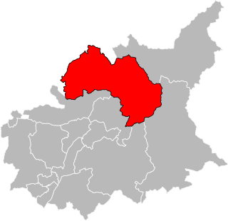
The arrondissement of Forcalquier is an arrondissement of France in the Alpes-de-Haute-Provence department in the Provence-Alpes-Côte d'Azur region. It has 97 communes. Its population is 95,990 (2016), and its area is 2,605.4 km2 (1,006.0 sq mi).

<span class="mw-page-title-main">Authon, Alpes-de-Haute-Provence</span> Commune in southeastern France

Authon is a commune in the Alpes-de-Haute-Provence department in the Provence-Alpes-Côte d'Azur region of south-eastern France.

<span class="mw-page-title-main">Aubenas-les-Alpes</span> Commune in southeastern France

Aubenas-les-Alpes is a commune in the Alpes-de-Haute-Provence department in the Provence-Alpes-Côte d'Azur region of south-eastern France.

<span class="mw-page-title-main">Aubignosc</span> Commune in Provence-Alpes-Côte dAzur, France

Aubignosc is a commune in the Alpes-de-Haute-Provence department in the Provence-Alpes-Côte d'Azur region of south-eastern France.

<span class="mw-page-title-main">Auzet</span> Commune in Provence-Alpes-Côte dAzur, France

Auzet is a commune in the Alpes-de-Haute-Provence department in the Provence-Alpes-Côte d'Azur region of south-eastern France.

<span class="mw-page-title-main">Barles</span> Commune in Provence-Alpes-Côte dAzur, France

Barles is a commune in the Alpes-de-Haute-Provence department in the Provence-Alpes-Côte d'Azur region of south-eastern France.

<span class="mw-page-title-main">Bayons</span> Commune in Provence-Alpes-Côte dAzur, France

Bayons is a commune in the Alpes-de-Haute-Provence department in the Provence-Alpes-Côte d'Azur region of south-eastern France.

<span class="mw-page-title-main">Ganagobie</span> Place in Provence-Alpes-Côte dAzur, France

Ganagobie is a commune in the Alpes-de-Haute-Provence department in southeastern France.

<span class="mw-page-title-main">Prads-Haute-Bléone</span> Commune in southeastern France

Prads-Haute-Bléone is a commune in the Alpes-de-Haute-Provence department and in the Provence-Alpes-Côte d'Azur region in southeastern France.

<span class="mw-page-title-main">Seyne</span> Commune in Provence-Alpes-Côte dAzur, France

Seyne is a commune in Alpes-de-Haute-Provence, a department of the Provence-Alpes-Côte d'Azur region in south-east France. It is roughly 30 km north of Digne.

<span class="mw-page-title-main">Sigonce</span> Commune in Provence-Alpes-Côte dAzur, France

Sigonce is a commune in the Alpes-de-Haute-Provence department in southeastern France.

<span class="mw-page-title-main">Le Vernet, Alpes-de-Haute-Provence</span> Commune in Provence-Alpes-Côte dAzur, France

Le Vernet is a commune in the Alpes-de-Haute-Provence department, and in the region of Provence-Alpes-Côte d'Azur, in southeastern France.

<span class="mw-page-title-main">Canton of Seyne</span> Canton in Provence-Alpes-Côte dAzur, France

The canton of Seyne is an administrative division in southeastern France. At the French canton reorganisation which came into effect in March 2015, the canton was expanded from 8 to 34 communes:

The canton of Turriers is a former administrative division in southeastern France. It was disbanded following the French canton reorganisation which came into effect in March 2015. It consisted of 7 communes, which joined the canton of Seyne in 2015. It had 1,265 inhabitants (2012).

<span class="mw-page-title-main">Alpes-de-Haute-Provence</span> Department in Provence-Alpes-Côte dAzur, France

Alpes-de-Haute-Provence or sometimes abbreviated as AHP, formerly until 1970 known as Bas-Alpes, is a department in the Provence-Alpes-Côte d'Azur region of France, bordering Alpes-Maritimes and Italy to the east, Var to the south, Vaucluse to the west, Drôme and Hautes-Alpes to the north. Formerly part of the province of Provence, it had a population of 164,308 in 2019, which makes it the 8th least populated department and the 94th most populated French department.

<span class="mw-page-title-main">Communauté d'agglomération Provence-Alpes</span> Communauté dagglomération in Alpes-de-Haute-Provence, France

The Communauté d'agglomération Provence-Alpes or Provence-Alpes Agglomération is a French agglomeration community, created on 21 October 2016, located in the department of Alpes-de-Haute-Provence, in region Provence-Alpes-Côte d'Azur. Its seat is Digne-les-Bains. Its area is 1574.0 km2. Its population was 47,382 in 2018, which is 29% of the population of Alpes-de-Haute-Provence.

<span class="mw-page-title-main">Digne Prealps</span> Mountain range in the French Prealps

The Digne Prealps are a massif in the southern part of the French Prealps located in the department of Alpes-de-Haute-Provence.

References

  1. "Répertoire national des élus: les maires" (in French). data.gouv.fr, Plateforme ouverte des données publiques françaises. 13 September 2022.
  2. "Populations légales 2021" (in French). The National Institute of Statistics and Economic Studies. 28 December 2023.
  3. Population en historique depuis 1968, INSEE
  4. "FR9301545 - VENTEROL - PIÉGUT - GRAND VALLON". Inventaire National du Patrimoine Naturel. Retrieved 12 March 2019.