Valensole

Last updated • 3 min readFrom Wikipedia, The Free Encyclopedia

Valensole
Valençòla (Occitan)
Lavender fileds in Valensole.jpg
Lavender fields in Valensole
Blason Valensole.svg
Location of Valensole
Valensole
France location map-Regions and departements-2016.svg
Red pog.svg
Valensole
Provence-Alpes-Cotes d'Azur region location map.svg
Red pog.svg
Valensole
Coordinates: 43°50′20″N5°59′04″E / 43.8389°N 5.9844°E / 43.8389; 5.9844
Country France
Region Provence-Alpes-Côte d'Azur
Department Alpes-de-Haute-Provence
Arrondissement Forcalquier
Canton Valensole
Intercommunality Durance-Luberon-Verdon Agglomération
Government
  Mayor (20202026) Gérard Aurric [1]
Area
1
127.77 km2 (49.33 sq mi)
Population
 (2021) [2]
3,155
  Density25/km2 (64/sq mi)
Time zone UTC+01:00 (CET)
  Summer (DST) UTC+02:00 (CEST)
INSEE/Postal code
04230 /04210
Elevation290–651 m (951–2,136 ft)
(avg. 595 m or 1,952 ft)
1 French Land Register data, which excludes lakes, ponds, glaciers > 1 km2 (0.386 sq mi or 247 acres) and river estuaries.

Valensole (French pronunciation: [valɑ̃sɔl] ; Occitan: Valençòla) is a commune in the Alpes-de-Haute-Provence department in the southeastern Provence-Alpes-Côte d'Azur region of France. Its inhabitants are called Valensolais (masculine) and Valensolaises (feminine). The commune numbered 3,173 inhabitants as of 2019.

Contents

Geography

The city itself, at 595 metres above sea level, is formed by an amphitheater on a hill between the Plateau de Valensole and the valley of Notre Dame. The commune is one of the most expansive of the region and contains many hamlets.

The river Asse forms most of the commune's northern border, then flows into the Durance, which forms all of its western border.

Geology

The beginning of the Tertiary era is marked by the lifting of the Pyrenees Mountains between 60 and 40 Ma. The repercussions of the lifting formed in the region of Valensole big mountains and little mountainous chains : Lure, Ventoux, Luberon, Nerthe, Étoile..., oriented east-west. During the Pyrenean raising, the Durance fault was active. The west lowered and the east raised, demarcating a vast river-lake zone : the Forcalquier basin, that receives, among others, the sediments coming from the east zone. For 15 thousand years, the Alps continue their formation. The powerful geologic movements accentuate again the east-west fold of the Provencal chains and mountains. The Durance fault is demonstrated once again. The occidental zone raises while the oriental zone sunk, forming a large depression in which waters of the ancestral torrents flowed, coming from south of the Estérel-Corso-Sarde Mountains. These powerful rivers, fed by violent climate phenomenons, transport large quantities of materials : pebbles, sand, clay, soluble limestone, taken into the depression where they accumulate to form an enormous deposit of Valensole's "poudingues", resulting from thousands of years of erosion in a karst environment.

Toward 8 Ma, the Estérel-corso-sardre mountain collapsed, isolating Corsica and Sardinia from the continent, which profoundly modified the hydrographic network. The rivers of Base-Provence that flow toward the plateau of Valensole and toward the Mediterranean Sea. The filling has followed from 5 or 6 thousand years. The visit deposit of Valensole is constituted by layers of pebbles more or less crude without the origins and the currents. The pebbles are cemented in different ways between the following - deposits, compressions, which demarcate the last layers and the layers most crumbly. The height of these deposits reach 838 meters toward Fourevière on the limit of the commune of the Mées and of Puimichel (between Guillot and the Allemands), and 400 meters on the heights of Volonne. Under the weight of this mass of materials, the terrestrial exterior sunk, that provokes movements of the deposit edge.

The levels move, tumble, subside, provoking folds and faults. The accumulation of conglomerates of Valensole spreads out for around 10 thousand years. Toward 3 Ma, the filling-in stopped.

The rivers will rearrange their valleys through the poudingue and the pluvial, glacial, fluvial, erosion will cut the relief of the plateau in forming small valleys and hills.


Town planning

According to the terminology defined by Insee and the zoning published in 2020, Valensole is an urban municipality. It belongs to the monocommunal urban unit of Valensole, with 3,204 inhabitants in 2017, thus being an isolated town. [3]

History

Politics and administration

Population and society

Demographics

Historical population
YearPop.±% p.a.
1793 3,532    
1806 3,566+0.07%
1821 3,281−0.55%
1831 3,521+0.71%
1836 3,284−1.38%
1841 3,135−0.92%
1846 3,049−0.55%
1851 3,151+0.66%
1856 3,134−0.11%
1861 3,072−0.40%
1866 3,021−0.33%
1872 3,186+0.89%
1876 3,065−0.96%
1881 3,020−0.30%
1886 2,907−0.76%
1891 2,807−0.70%
1896 2,624−1.34%
1901 2,550−0.57%
YearPop.±% p.a.
1906 2,509−0.32%
1911 2,357−1.24%
1921 1,917−2.05%
1926 1,924+0.07%
1931 1,960+0.37%
1936 1,966+0.06%
1946 1,790−0.93%
1954 1,784−0.04%
1962 1,712−0.51%
1968 1,791+0.75%
1975 1,721−0.57%
1982 1,944+1.76%
1990 2,202+1.57%
1999 2,334+0.65%
2007 2,700+1.84%
2012 3,280+3.97%
2017 3,204−0.47%
Source: EHESS [4] and INSEE (1968-2017) [5]

Economy

See also

Related Research Articles

<span class="mw-page-title-main">Vaucluse</span> Department in Provence-Alpes-Côte dAzur, France

Vaucluse is a department in the southeastern French region of Provence-Alpes-Côte d'Azur. It had a population of 561,469 as of 2019. The department's prefecture is Avignon.

<span class="mw-page-title-main">Hautes-Alpes</span> Department in Provence-Alpes-Côte dAzur, France

Hautes-Alpes is a department in the Provence-Alpes-Côte d'Azur region of Southeastern France. It is located in the heart of the French Alps, after which it is named. Hautes-Alpes had a population of 141,220 as of 2019, which makes it the third least populated French department. Its prefecture is Gap; its sole subprefecture is Briançon. Its INSEE and postal code is 05.

<span class="mw-page-title-main">Banon, Alpes-de-Haute-Provence</span> Commune in Provence-Alpes-Côte dAzur, France

Banon is a commune in the department of Alpes-de-Haute-Provence in the Provence-Alpes-Côte d'Azur region of south-eastern France.

<span class="mw-page-title-main">Saint-Raphaël, Var</span> Commune in Provence-Alpes-Côte dAzur, France

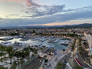
Saint-Raphaël is a commune in the Var department, Provence-Alpes-Côte d'Azur region, Southeastern France.

<span class="mw-page-title-main">Caumont-sur-Durance</span> Commune in Provence-Alpes-Côte dAzur, France

Caumont-sur-Durance is a commune in the Vaucluse department in the Provence-Alpes-Côte d'Azur region of Southeastern France.

<span class="mw-page-title-main">Barrême</span> Commune in Provence-Alpes-Côte dAzur, France

Barrême is a rural commune in the southeastern French department of Alpes-de-Haute-Provence.

<span class="mw-page-title-main">Vaumeilh</span> Commune in Provence-Alpes-Côte dAzur, France

Vaumeilh is a commune in the Alpes-de-Haute-Provence department in the Provence-Alpes-Côte d'Azur region in southeastern France.

<span class="mw-page-title-main">Authon, Alpes-de-Haute-Provence</span> Commune in southeastern France

Authon is a commune in the Alpes-de-Haute-Provence department in the Provence-Alpes-Côte d'Azur region of south-eastern France.

<span class="mw-page-title-main">Aubenas-les-Alpes</span> Commune in southeastern France

Aubenas-les-Alpes is a commune in the Alpes-de-Haute-Provence department in the Provence-Alpes-Côte d'Azur region of south-eastern France.

<span class="mw-page-title-main">Aubignosc</span> Commune in Provence-Alpes-Côte dAzur, France

Aubignosc is a commune in the Alpes-de-Haute-Provence department in the Provence-Alpes-Côte d'Azur region of south-eastern France.

<span class="mw-page-title-main">Auzet</span> Commune in Provence-Alpes-Côte dAzur, France

Auzet is a commune in the Alpes-de-Haute-Provence department in the Provence-Alpes-Côte d'Azur region of south-eastern France.

<span class="mw-page-title-main">Barras, Alpes-de-Haute-Provence</span> Commune in Provence-Alpes-Côte dAzur, France

Barras is a commune in the Alpes-de-Haute-Provence department in the Provence-Alpes-Côte d'Azur region of south-eastern France.

<span class="mw-page-title-main">Bayons</span> Commune in Provence-Alpes-Côte dAzur, France

Bayons is a commune in the Alpes-de-Haute-Provence department in the Provence-Alpes-Côte d'Azur region of south-eastern France.

<span class="mw-page-title-main">Corbières-en-Provence</span> Commune in Provence-Alpes-Côte dAzur, France

Corbières-en-Provence, simply known as Corbières until 2018, is a commune in the Alpes-de-Haute-Provence department in the Provence-Alpes-Côte d'Azur region of Southeastern France. Its inhabitants are called Corbiérains (masculine) and Corbiéraines (feminine).

<span class="mw-page-title-main">L'Escale</span> Commune in Provence-Alpes-Côte dAzur, France

L'Escale is a commune in the Alpes-de-Haute-Provence department in southeastern France. It is located on the eastern bank of the Durance opposite Château-Arnoux-Saint-Auban.

<span class="mw-page-title-main">Oraison</span> Commune in Provence-Alpes-Côte dAzur, France

Oraison is a commune in the Alpes-de-Haute-Provence department in southeastern France.

<span class="mw-page-title-main">Le Castellet, Alpes-de-Haute-Provence</span> Commune in Provence-Alpes-Côte dAzur, France

Le Castellet is a rural commune in the Alpes-de-Haute-Provence department in the Provence-Alpes-Côte d'Azur region in Southeastern France. It is located north of Valensole, east of the Valley of the Durance. In 2021 it had a population of 301.

<span class="mw-page-title-main">Freissinières</span> Commune in Provence-Alpes-Côte dAzur, France

Freissinières is a commune in the Hautes-Alpes department in southeastern France.

<span class="mw-page-title-main">Alpes-de-Haute-Provence</span> Department in Provence-Alpes-Côte dAzur, France

Alpes-de-Haute-Provence, formerly until 1970 known as Basses-Alpes, is a department in the Provence-Alpes-Côte d'Azur region of France, bordering Alpes-Maritimes and Italy to the east, Var to the south, Vaucluse to the west, Drôme and Hautes-Alpes to the north. Formerly part of the province of Provence, it had a population of 164,308 in 2019, which makes it the 8th least populated department and the 94th most populated French department.

Durance-Luberon-Verdon Agglomération is the communauté d'agglomération, an intercommunal structure, centred on the town of Manosque. It is located in the Alpes-de-Haute-Provence and Var departments, in the Provence-Alpes-Côte d'Azur region, southeastern France. Created in 2013, its seat is in Manosque. Its area is 838.5 km2. Its population was 62,563 in 2019, of which 22,528 in Manosque proper.

References

  1. "Répertoire national des élus: les maires". data.gouv.fr, Plateforme ouverte des données publiques françaises (in French). 2 December 2020.
  2. "Populations légales 2021" (in French). The National Institute of Statistics and Economic Studies. 28 December 2023.
  3. Urban Unit 2020 of Valensole, INSEE
  4. Des villages de Cassini aux communes d'aujourd'hui: Commune data sheet Valensole, EHESS (in French).
  5. Population en historique depuis 1968, INSEE