
The Gulf of California, also known as the Sea of Cortés or Sea of Cortez, or less commonly as the Vermilion Sea, is a marginal sea of the Pacific Ocean that separates the Baja California Peninsula from the Mexican mainland. It is bordered by the states of Baja California, Baja California Sur, Sonora, and Sinaloa with a coastline of approximately 4,000 km (2,500 mi). Rivers that flow into the Gulf of California include the Colorado, Fuerte, Mayo, Sinaloa, Sonora, and the Yaqui. The surface of the gulf is about 160,000 km2 (62,000 sq mi). Maximum depths exceed 3,000 meters (9,800 ft) because of the complex geology, linked to plate tectonics.
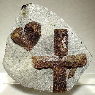
Staurolite is a reddish brown to black, mostly opaque, nesosilicate mineral with a white streak. It crystallizes in the monoclinic crystal system, has a Mohs hardness of 7 to 7.5 and the chemical formula: Fe2+2Al9O6(SiO4)4(O,OH)2. Magnesium, zinc and manganese substitute in the iron site and trivalent iron can substitute for aluminium.

The City of Rocks National Reserve, also known as the Silent City of Rocks, is a United States National Reserve and state park in south-central Idaho, approximately 2 miles (3.2 km) north of the border with Utah. It is widely known for its enormous granite rock formations and excellent rock climbing.

James Patrick Quirk is an American former professional baseball player and coach. He played as a catcher in Major League Baseball from 1975 to 1992. Quirk was a member of the world champion 1985 Kansas City Royals team.

Vasquez Rocks Natural Area Park is a 932-acre (377-hectare) park located in the Sierra Pelona in northern Los Angeles County, California. It is known for its rock formations, the result of sedimentary layering and later seismic uplift. It is located near the town of Agua Dulce, between the cities of Santa Clarita and Palmdale. The area is visible from the Antelope Valley Freeway. It has been used as a location for films and television programs on many occasions.

The Rock Abrasion Tool (RAT) is a grinding and brushing installation on NASA’s twin Mars Exploration Rovers, Spirit (MER-A) and Opportunity (MER-B), which landed on Mars in January 2004. It was designed, developed and continues to be operated by Honeybee Robotics LTD, a developer of specialized robots, automated technologies and related systems.
Nelson Arturo Liriano Bonilla is a Dominican former professional baseball second baseman. He played in Major League Baseball from 1987 through 1998 for the Toronto Blue Jays, Minnesota Twins, Kansas City Royals, Colorado Rockies, Pittsburgh Pirates, and Los Angeles Dodgers. In 1999, he played in one game for the Chunichi Dragons of Nippon Professional Baseball (NPB).

Seal Rock is a group of small rock formation islands in the Lands End area of the Outer Richmond District in western San Francisco, California. They are located just offshore in the Pacific Ocean, at the north end of the Ocean Beach, near the Cliff House and Sutro Baths ruins.

In optical mineralogy and petrography, a thin section is a thin slice of a rock or mineral sample, prepared in a laboratory, for use with a polarizing petrographic microscope, electron microscope and electron microprobe. A thin sliver of rock is cut from the sample with a diamond saw and ground optically flat. It is then mounted on a glass slide and then ground smooth using progressively finer abrasive grit until the sample is only 30 μm thick. The method uses the Michel-Lévy interference colour chart to determine thickness, typically using quartz as the thickness gauge because it is one of the most abundant minerals.

Twin Rocks is an unincorporated community in Tillamook County, Oregon, United States, on the Oregon Coast. Twin Rocks, founded as a summer resort community, was named for two offshore rocks, 100 feet (30 m) high, in the Pacific Ocean. Twin Rocks post office was established in 1914, with William E. Dunsmoor as the first postmaster. The post office closed in 1954.
Salt Point State Park is a state park in Sonoma County, California, United States. The park covers 6,000 acres (2,428 ha) on the coast of Northern California, with 20 miles (32 km) of hiking trails and over 6 miles (9.7 km) of a rough rocky coastline including Salt Point which protrudes into the Pacific Ocean. The park also features the first underwater preserves in California. The constant impact of the waves forms the rocks into many different shapes. These rocks continue underwater providing a wide variety of habitats for marine organisms. The activities at Salt Point include hiking, camping, fishing, scuba diving and many others. The weather is often cool with fog and cold winds, even during the summer.

Howel Williams was an American geologist and volcanologist.
The Castro Rocks are several rocks in Richmond, California protruding from the waters in San Francisco Bay between Castro Point and Red Rock Island.The rocks lie almost directly under the Richmond-San Rafael Bridge (I-580).

SS California was a twin-screw steamer that D. and W. Henderson and Company of Glasgow built for the Anchor Line in 1907 as a replacement for the aging ocean liner Astoria, which had been in continuous service since 1884. She worked the Glasgow to New York transatlantic route and was sunk by the German submarine SM U-85 on 7 February 1917.

The Coyote Mountains are a small mountain range in San Diego and Imperial Counties in southern California. The Coyotes form a narrow ESE trending 2 mi (3.2 km) wide range with a length of about 12 mi (19 km). The southeast end turns and forms a 2 mi (3.2 km) north trending "hook". The highest point is Carrizo Mountain on the northeast end with an elevation of 2,408 feet (734 m). Mine Peak at the northwest end of the range has an elevation of 1,850 ft (560 m). Coyote Wash along I-8 along the southeast margin of the range is 100 to 300 feet in elevation. Plaster City lies in the Yuha Desert about 5.5 mi (8.9 km) east of the east end of the range.

The Riverside Mountains are a mountain range in Riverside County, California. The town of Vidal, California is located in the West Riverside Mountains.
Shock metamorphism or impact metamorphism describes the effects of shock-wave related deformation and heating during impact events.

The Cape-Pigeon Rocks are twin rocky promontories on the western side of Watt Bay, 6 kilometres (3 nmi) south of Garnet Point. They were discovered by the Australasian Antarctic Expedition (1911–14) under Douglas Mawson, who gave the name because of the large rookery of Cape petrels here. The Advisory Committee on Antarctic Names added a hyphen between the first and second words in the specific part of the name to reduce ambiguity and emphasize the generic term "Rocks".
Twin Rocks is an unincorporated community in Cambria County, Pennsylvania, United States. The community is located along Pennsylvania Route 271, 2.4 miles (3.9 km) northwest of Nanty Glo. Twin Rocks has a post office with ZIP code 15960.


