
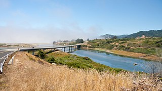
The Navarro River is a 28.3-mile-long (45.5 km) river in Mendocino County, California, United States. It flows northwest through the Coastal Range to the Pacific Ocean. The main stem of the Navarro River begins less than 1 mile (2 km) south of the town of Philo at the confluence of Rancheria Creek and Anderson Creek. The mouth of the Navarro is 10 miles (16 km) south of the city of Mendocino. State Route 128 starts from the intersection of State Route 1 at the mouth of the Navarro River, and follows the river valley upstream to Philo. The river is close to the highway through the lower canyon but is some distance south of the highway as the Anderson Valley widens upstream of Wendling.

The Gualala River is a river on the northern coast of California. Most of the river is in Sonoma County, but a portion is in Mendocino County. The headwaters of the 40-mile-long (64 km) river are high in the Coast Range, and it empties into the Pacific Ocean. For its last few miles, it forms the boundary between Sonoma County and Mendocino County.

Whitethorn is an unincorporated community in Humboldt County, California. It is located 9.5 miles (15 km) southwest of Garberville, at an elevation of 1024 feet, population 817. Whitethorn shares a zip code with Shelter Cove, California. It is located along California's Lost Coast. The ZIP Code is 95589.

Empire is a former settlement in Mendocino County, California. It was located on the South Fork of the Eel River 7 miles (11 km) east-southeast of Mendocino, at an elevation of 1339 feet. Empire still appeared on maps as of 1952.

Fair Oaks is an unincorporated community in Mendocino County, California. It is located 2 miles (3.2 km) south-southeast of Willits, at an elevation of 1444 feet.

Hales Grove is an unincorporated community in Mendocino County, California. It is located on California State Route 1 adjacent to the South Fork of Mule Creek 11 miles (18 km) south of Piercy, at an elevation of 1138 feet.
Lane Redwood Flat is a former settlement in Mendocino County, California. It was located on the South Fork of the Eel River 6 miles (9.7 km) south-southeast of Piercy, at an elevation of 676 feet.
Navarro, formerly known as Wendling, is an unincorporated community in Mendocino County in the U.S. state of California. It is located 18 miles (29 km) west of Ukiah, at an elevation of 269 feet (82 m). It may be reached via east-west California State Route 128, which connects it to the Pacific coast to the west and to the Anderson Valley to the southeast.
Piercy is an unincorporated community in Mendocino County, California. It is located on the South Fork of the Eel River 9 miles (14 km) north-northwest of Leggett, at an elevation of 794 feet.
Reynolds is a former settlement in Mendocino County, California. It was located on the South Fork of the Eel River 2.5 miles (4 km) south-southeast of Piercy, at an elevation of 830 feet. Reynolds still appeared on maps as of 1950.
River Garden is a former settlement in Mendocino County, California. It was located on the railroad and on the South Fork of the Eel River 3.5 miles (5.6 km) south-southeast of Spyrock, at an elevation of 797 feet. It still appeared on maps as of 1952.
Riverdale is an unincorporated community in Mendocino County, California. It is located near U.S. Route 101 on the South Fork of the Eel River 2.25 miles (3.6 km) northwest of Leggett, at an elevation of 732 feet.
The Forks is an unincorporated community in Mendocino County, California. It is located 3 miles (4.8 km) north of Ukiah, at an elevation of 640 feet.
Tolson is a former settlement in Mendocino County, California. It was located on the South Fork of the Eel River 5 miles (8 km) north-northeast of Hales grove.
North Fork House is a former settlement in Mendocino County, California. It was located 1 mile (1.6 km) west of Navarro.
Carbon is a former settlement in Mendocino County, California. It was located on the Middle Fork of the Eel River 6 miles (9.7 km) from Covelo.
Cedar Creek is an 11.2-mile-long (18.0 km) tributary of the South Fork Eel River in Mendocino County in the U.S. state of California. The creek begins southeast of Red Mountain, at an elevation of 778 feet (237 m). It makes an S-curve west-northwest then bends sharply south, dropping into the valley of the South Fork Eel. The confluence is south of the city of Leggett, on the river's right bank. The only named tributary of Cedar Creek is Little Cedar Creek, a headwaters tributary. Big Dann Creek joins the South Fork Eel on the same bank, just upstream of Cedar Creek, while the next major tributary downstream of Cedar is Rock Creek. The Cedar Creek watershed is rugged and has few tributaries.
The East Branch South Fork Eel River, a tributary of the South Fork Eel River, is formed by the confluence of Cruso Cabin Creek and Elkhorn Creek, in Mendocino County in the U.S. state of California. The river is roughly 25 miles (40 km) long, meandering west to its confluence with the South Fork Eel at Benbow Lake State Recreation Area. Major tributaries of the East Branch include Buck Mountain Creek, Squaw Creek, Rays Creek, and Tom Long Creek. The river flows west, turns north, and flows west again, through rugged terrain in the Coast Range of California. The East Branch is the South Fork Eel's largest tributary.

The North Fork Eel River is the smallest of four major tributaries of the Eel River in northwestern California in the United States. It drains a rugged wilderness area of about 286 square miles (740 km2) in the California Coast Ranges, and flows through national forests for much of its length. Very few people inhabit the relatively pristine watershed of the river; there are no operational stream gauges and only one bridge that crosses the river, near the boundary between Trinity and Mendocino Counties.
Ten Mile River is in northern Mendocino County, California, United States. It is named for the fact that its mouth is 10 miles (16 km) north of the mouth of the Noyo River. The lands around lower Ten Mile River provide valuable freshwater and saltwater marsh habitat for a variety of birds. The Ten Mile River Estuary, Ten Mile Beach, and Ten Mile State Marine Reserve together form a marine protected area that extends from the estuary out to five nautical miles. Ten Mile Beach is also part of MacKerricher State Park, which extends approximately five miles southward from the mouth of the river to Cleone and includes approximately 1,300 acres (530 ha) of the "most pristine stretch of sand dunes [in California]."


