
Loganville is a city in Walton and Gwinnett counties, Georgia, United States. The population was 10,458 at the 2010 census. Loganville is located about 36 mi (58 km) east of Atlanta and is part of the Atlanta metropolitan area.
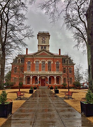
Monroe is a city in Walton County, Georgia, United States, serving as the county seat. It is located both one hour east of Atlanta via US 78 and GA 138 to I-20 and east of Hartsfield–Jackson International Airport and is one of the exurban cities in the Atlanta metropolitan area. The population was 14,928 at the 2020 U.S. census.
Pine Grove is a census-designated place in Amador County, California. It lies at an elevation of 2513 feet. The population was 2,219 at the 2010 census. It is located at 38°24′47″N120°39′32″W, along State Route 88. The community is in ZIP code 95665 and area code 209.

Famoso is an unincorporated community in Kern County, California. It is located on Poso Creek 5.5 miles (8.9 km) south-southeast of McFarland, at an elevation of 427 feet (130 m). Famoso is located at the junction of State Route 99 and the eastern terminus of State Route 46. The town is famous for its nut groves and especially the race track - Auto Club Famoso Raceway.
Norden is a small unincorporated community in Nevada County, California, United States, about 9 miles (14 km) west of Truckee. The community is located on a former portion of U.S. Route 40 near Interstate 80 and lies along the historical First transcontinental railroad, 1.5 miles (2.4 km) west of Donner Pass.
Irishtown is a former settlement in Amador County, California, United States. It was located 1.5 miles (2.4 km) south-southwest of Pine Grove, at an elevation of 1972 feet. The townsite lies within the boundaries of Pine Grove. Irishtown is a former Miwok settlement.
Cedar Grove is an unincorporated community and the location of the visitor center in Kings Canyon National Park. Situated near the South Fork of the Kings River, in Fresno County, California, Cedar Grove and Grant Grove Village are the only commercially developed areas in the park. Facilities include the Cedar Grove Visitor Center, the Cedar Grove Lodge, a market and four campgrounds. The road into the canyon closes mid-November to mid-April.
Pine Grove was a resort in Lake County, California. It is located 1.5 miles (2.4 km) northwest of Whispering Pines, at an elevation of 2,520 feet.
Kibesillah is an unincorporated community in Mendocino County, California. It is located on California State Route 1 near the Pacific coast 3.25 miles (5.2 km) south of Westport, at an elevation of 138 feet.
Newport is an unincorporated community in Mendocino County, California. It is located on California State Route 1 near the Pacific Ocean 4.25 miles (6.8 km) south of Westport, at an elevation of 135 feet.
Pine Grove is an unincorporated community in Mendocino County, California. It is located 3 miles (4.8 km) north-northwest of Mendocino, at an elevation of 167 feet. On the ocean just west of the community is the Point Cabrillo Light station.
The Grove is an unincorporated community in Merced County, California. It is located 3.5 miles (5.6 km) north of Atwater, at an elevation of 197 feet.

Pleasant Grove is an unincorporated community in Sutter County, California, United States. Pleasant Grove is 7.5 miles (12.1 km) southeast of Nicolaus. Pleasant Grove has a post office with ZIP code 95668.
Big Bend or Rainbow is an unincorporated community in Placer County, California. Big Bend is located on the South Yuba River, 1 mile (1.6 km) east-southeast of Cisco Grove. It lies at an elevation of 5738 feet.
Cisco Grove is an unincorporated community in Placer County, California. Cisco Grove is located 7 miles (11.3 km) east of Emigrant Gap. It lies at an elevation of 5643 feet.

Cisco is an unincorporated community in Placer County, California. Cisco is located on the Union Pacific Railroad, 0.5 miles (0.8 km) south-southwest of Cisco Grove. It lies at an elevation of 5938 feet.
Rainbow is an unincorporated community in Placer County, California. Rainbow is located 1.5 miles (2.4 km) east of Cisco Grove. It lies at an elevation of 5781 feet.

Middle Grove is an unincorporated community in Monroe County, Missouri, United States.


