Cahto, California

Last updated

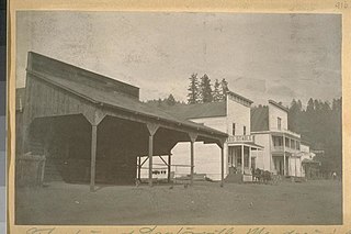
Cahto [1] is a former settlement in Mendocino County, California. [2] It was located 3 miles (4.8 km) southwest of Laytonville. [2]

Mendocino County, California County in California, United States

Mendocino County is a county located on the north coast of the U.S. state of California. As of the 2010 census, the population was 87,841. The county seat is Ukiah.

California State of the United States of America

California is a state in the Pacific Region of the United States. With 39.6 million residents, California is the most populous U.S. state and the third-largest by area. The state capital is Sacramento. The Greater Los Angeles Area and the San Francisco Bay Area are the nation's second and fifth most populous urban regions, with 18.7 million and 8.8 million residents respectively. Los Angeles is California's most populous city, and the country's second most populous, after New York City. California also has the nation's most populous county, Los Angeles County, and its largest county by area, San Bernardino County. The City and County of San Francisco is both the country's second-most densely populated major city after New York City and the fifth-most densely populated county, behind only four of the five New York City boroughs.

Laytonville, California census-designated place in California, United States

Laytonville is a census-designated place (CDP) in Mendocino County, California, United States. Laytonville, is located 20 miles (32 km) north-northwest of Willits, at an elevation of 1670 feet. The population was 1,227 at the 2010 census, down from 1,301 at the 2000 census.

Cahto was founded by John P. Simpson and Robert White in 1856. [2] They built a hotel there in 1861, and a store in 1865. [2] A post office operated at Cahto from 1863 to 1901. [2] The Independent Order of Odd Fellows maintained Cahto Lodge No. 206 in the town as well, which met in a two-story hall constructed in 1872 that doubled as a public hall and meeting place. [3]

Independent Order of Odd Fellows an American branch of Odd Fellows fraternity

The Independent Order of Odd Fellows (IOOF) is a non-political and non-sectarian international fraternal order of Odd Fellowship. It was founded in 1819 by Thomas Wildey in Baltimore, Maryland, United States. Evolving from the Order of Odd Fellows founded in England during the 1700s, the IOOF was originally chartered by the Independent Order of Oddfellows Manchester Unity in England but has operated as an independent organization since 1842, although it maintains an inter-fraternal relationship with the English Order. The order is also known as the Triple Link Fraternity, referring to the order's "Triple Links" symbol, alluding to its motto "Friendship, Love and Truth".

"Cahto" means "lake" in the language of the local Pomo people. [4]

Related Research Articles

Alpine, Mendocino County, California Unincorporated community in California, United States

Alpine is an unincorporated community in Mendocino County, California. It is located on the California Western Railroad 12 miles (19 km) north of Comptche, at an elevation of 233 feet.

Clare Mill, California Unincorporated community in California, United States

Clare Mill is an unincorporated community in Mendocino County, California. It is located on the California Western Railroad 4 miles (6.4 km) west of Willits, at an elevation of 961 feet.

Crowley, Mendocino County, California Unincorporated community in California, United States

Crowley is an unincorporated community in Mendocino County, California. It is located 4 miles (6.4 km) west of Willits, at an elevation of 1237 feet.

Fair Oaks, Mendocino County, California Unincorporated community in California, United States

Fair Oaks is an unincorporated community in Mendocino County, California. It is located 2 miles (3.2 km) south-southeast of Willits, at an elevation of 1444 feet.

Glenblair, California Unincorporated community in California, United States

Glenblair is an unincorporated community in Mendocino County, California. It is located 15 miles (24 km) north-northwest of Comptche, at an elevation of 207 feet.

Lane Redwood Flat, California Former settlement in California, United States

Lane Redwood Flat is a former settlement in Mendocino County, California. It was located on the South Fork of the Eel River 6 miles (9.7 km) south-southeast of Piercy, at an elevation of 676 feet.

Laughlin, California Unincorporated community in California, United States

Laughlin is an unincorporated community in Mendocino County, California. It is located on the Northwestern Pacific Railroad 7.5 miles (12 km) west-southwest of Potter Valley, at an elevation of 863 feet.

Oasis, Mendocino County, California Unincorporated community in California, United States

Oasis is an unincorporated community in Mendocino County, California. It is located 6 miles (9.7 km) east of Hopland, at an elevation of 1,929 feet (588 m).

Philbrick Mill, California Unincorporated community in California, United States

Philbrick Mill is an unincorporated community in Mendocino County, California. It is located 8.5 miles (14 km) northwest of Boonville, at an elevation of 479 feet.

Ramsey, Mendocino County, California Unincorporated community in California, United States

Ramsey is an unincorporated community in Mendocino County, California. It is located on the Eel River and Northwestern Pacific Railroad 6.5 miles (10 km) north of Spyrock, at an elevation of 686 feet.

Redwood Lodge, Mendocino County, California Unincorporated community in California, United States

Redwood Lodge is an unincorporated community in Mendocino County, California. It is located on the California Western Railroad 13 miles (21 km) north-northwest of Comptche, at an elevation of 66 feet.

South Fork, Mendocino County, California Unincorporated community in California, United States

South Fork is an unincorporated community in Mendocino County, California. It is located on the California Western Railroad 13 miles (21 km) north-northwest of Comptche, at an elevation of 46 feet.

The Oaks, Mendocino County, California Unincorporated community in California, United States

The Oaks is an unincorporated community in Mendocino County, California. It is located 7.5 miles (12 km) southwest of Hopland, at an elevation of 1,083 feet.

Whitesboro, California Unincorporated community in California, United States

Whitesboro was an unincorporated community in Mendocino County, California. It was located 1 mile (1.6 km) south-southeast of Albion, at an elevation of 39 feet.

Dellavan is a former settlement in Mendocino County, California. It was located near the Pacific Ocean between Westport and Hardy.

Fountain is a former settlement in Mendocino County, California. It was located on the railroad 2.5 miles (4 km) south of Hopland.

Christine Junction is a former settlement in Mendocino County, California. It was located 8 miles (13 km) northwest of Boonville.

Salmon Creek is a former settlement in Mendocino County, California. It was located near the site of present-day Whitesboro.

Carbon is a former settlement in Mendocino County, California. It was located on the Middle Fork of the Eel River 6 miles (9.7 km) from Covelo.

Tilly is a former settlement in Mendocino County, California. It was located 9 miles (14 km) west of Cahto.

References

  1. The California Mining Bureau's 1917 map has the town name misspelled as Canto. Durham, David L. (1998). California's Geographic Names: A Gazetteer of Historic and Modern Names of the State. Clovis, Calif.: Word Dancer Press. p. 91. ISBN   1-884995-14-4.
  2. 1 2 3 4 5 Durham, David L. (1998). California's Geographic Names: A Gazetteer of Historic and Modern Names of the State. Clovis, Calif.: Word Dancer Press. p. 91. ISBN   1-884995-14-4.
  3. Palmer, Lyman L. (1880). History of Mendocino County, California : Comprising its geography, geology, topography, climatography, springs and timber. Also, extended sketches of its mills and milling, mines and mining interests : also a historical sketch of the state of California, in which is embodied the raising of the bear flag. Allen Bowen & Co.
  4. Kroeber, Alfred L. (1916), "California place names of Indian origin" (PDF), University of California Publications in American Archaeology and Ethnology, 12 (2): 31–69, archived from the original (PDF) on 2011-07-20, retrieved 2010-08-22.