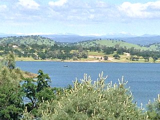
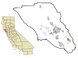
Valley Springs is a census-designated place (CDP) in Calaveras County, California, United States, in the foothills of the Sierra Nevada Mountain Range. Valley Springs is registered as a California Historical Landmark, number 251.

Byron is a census designated place (CDP) in Contra Costa County, California, United States.

Calistoga is a city in Napa County, in California's Wine Country. During the 2010 census, the population was 5,155.

Desert Hot Springs is a city in Riverside County, California, United States. The city is located within the Coachella Valley geographic region, sometimes referred to as the Desert Empire. The population was 25,938 at the 2010 census, up from 16,582 at the 2000 census. The city has experienced rapid growth since the 1970s, when there were 2,700 residents.
Boyes Hot Springs is a census-designated place (CDP) in Sonoma Valley, Sonoma County, California, United States. The population was 6,656 people at the 2010 census. Resorts in Boyes Hot Springs, El Verano, Fetters Hot Springs, and Agua Caliente were popular health retreats for tourists from San Francisco and points beyond until the middle of the 20th century because of the geothermic hot springs that still well up from deep within the earth.

Fetters Hot Springs-Agua Caliente is a census-designated place (CDP) in Sonoma Valley, Sonoma County, California, in the United States. As of the 2010 census, the CDP population was 4,144. The name Agua Caliente translates into English, from Spanish, as hot water, referring to the hot springs historically found in the area.
A spa town is a resort town based on a mineral spa. Patrons visit spas to "take the waters" for their purported health benefits. The word spa is derived from the name of Spa, a town in Belgium.
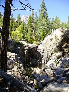
Grover Hot Springs State Park is a state park of California, USA, containing natural hot springs on the eastern side of the Sierra Nevada. Park amenities include a swimming pool complex fed by the hot springs, as well as a campground, picnic area, and hiking trails. The 553-acre (224 ha) park was established in 1959.

Jacumba Hot Springs is an unincorporated community in the Mountain Empire area of southeastern San Diego County, California, United States. For statistical purposes, the United States Census Bureau defined Jacumba Hot Springs as a census-designated place (CDP) for the first time in the 2010 census, with a population of 561. The census definition of the area may not precisely correspond to local understanding of the area with the same name. The ZIP code is 91934 and the town lies within area code 619. Its elevation is 2,829 feet (862 m) above mean sea level (AMSL). On February 26, 2013, the Federal Geographic Names Commission approved a petition by a citizen committee to change the town's name from Jacumba to Jacumba Hot Springs.

Palm Springs is a desert resort city in Riverside County, California, United States, within the Colorado Desert's Coachella Valley. The city covers approximately 94 square miles (240 km2), making it the largest city in Riverside County by land area. With multiple plots in checkerboard pattern, more than 10% of the city is part of the Agua Caliente Band of Cahuilla Indians reservation land. Traditionally the Cahuilla refer to the Palm Springs area as Sec-he or Se-Khi.
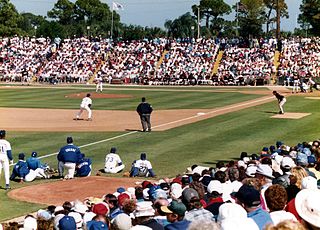
In Major League Baseball (MLB), spring training is a series of practices and exhibition games preceding the start of the regular season. Spring training allows new players to try out for roster and position spots, and gives established players practice time prior to competitive play. Spring training has always attracted fan attention, drawing crowds who travel to the warm climates of Arizona and Florida to enjoy the weather and watch their favorite teams play, and spring training usually coincides with spring break for many US students.

Mono Hot Springs is a summer resort and campground at a group of hot springs in Fresno County, central California. It is located within the Sierra National Forest, 70 miles (110 km) northeast of Fresno via California State Route 168.

Wilbur Hot Springs is a naturally occurring historic hot spring, health sanctuary, personal retreat and 1,800-acre (7.3 km2) nature reserve in Williams, Colusa County, in northern California, United States, about 2 hours northeast of the San Francisco Bay Area and 1½ hours north of the Sacramento Airport.

Miracle Hot Springs is an unincorporated community in the Kern River Valley, in Kern County, California. It is located along the Kern River in the SEQUOIA NATIONAL FOREST, KERN RIVER RANGER DISTRICT 10 miles (16 km)West of Lake Isabella, California, at an elevation of 2,382 feet (726 m).
Ornbaun is a former settlement in Mendocino County, California. It was located on Rancheria Creek just east of Ornbaun Valley.

Benton Hot Springs is an unincorporated community in Mono County, California. It is located 3 miles (4.8 km) west-southwest of Benton and 31 miles (50 km) north-northwest of Bishop, at an elevation of 5630 feet.

Tassajara Hot Springs is an unincorporated community in Monterey County, California, located 9 miles (14 km) east-northeast of Partington Point, at an elevation of 1637 feet.
Brockway is an unincorporated community in Placer County, California. Brockway is located on the north shore of Lake Tahoe on State Line Point, adjacent to the Nevada state border. It lies at an elevation of 6266 feet.

California Hot Springs is a census-designated place in Tulare County, California, United States. California Hot Springs is 20 miles (32 km) east of Ducor. California Hot Springs has a post office with ZIP code 93207. The population was 37 at the 2010 census.
B Bar H Ranch, California is an unincorporated area with cultural and historical features and is a residential community in Riverside County, California. B Bar H Ranch is located between Palm Springs and Desert Hot Springs in the Seven Palms Valley. California Home Town Locator states the B Bar H Ranch Latitude is 33.9102927 and Longitude is -116.4819566. The GNIS entry date is January 19, 1981. B Bar H Ranch sits at an elevation of 784 feet (239 m). B Bar H Ranch is approximately eight miles north of Palm Springs, California and approximately six miles south of Desert Hot Springs, California. B Bar H Ranch's approximate 240 acres are bordered by 18th Avenue to the north, Mountain View Road to the east, 20th Avenue to the south, and Bubbling Wells Road to the west. B Bar H Ranch consisted of approximately 899 residents as of the 2010 US Census.


