Mendocino is an unincorporated community in Mendocino County, California, United States. Mendocino is located 9.5 miles (15 km) south of Fort Bragg, at an elevation of 154 feet. The population of the census-designated place (CDP) was 894 at the 2010 census, up from 824 at the 2000 census. The town's name comes from Cape Mendocino, named by early Spanish navigators in honor of Antonio de Mendoza, Viceroy of New Spain. In turn, the etymology of Mendoza is "cold mountain."

Talmage is a census-designated place (CDP) in Mendocino County, California, United States. Talmage is located 2.5 miles (4 km) east-southeast of Ukiah, at an elevation of 627 feet. The population was 1,130 at the 2010 census, down from 1,141 at the 2000 census. It lies on the Southeastern region of Ukiah Valley and is home to the famous City of Ten Thousand Buddhas, one of the largest Chinese Zen Buddhist temples in the United States. The town's name honors early settler Junius Talmage.

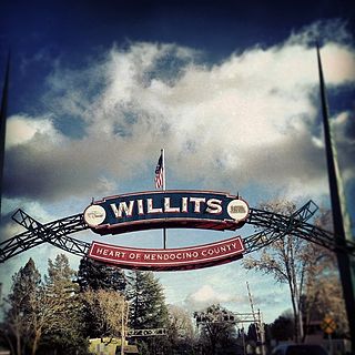
Willits is a city in Mendocino County, California, United States. Willits is located 20 miles (32 km) north-northwest of Ukiah, at an elevation of 1391 feet. The population was 4,888 at the 2010 census, down from 5,073 at the 2000 census. Willits is at the center of Mendocino County and at the beginning of the county's extensive redwood forests as approached by Highway 101 from the south.

Philo is a census-designated place in Mendocino County, California. It is located 5.5 miles (9 km) northwest of Boonville, at an elevation of 331 feet. The population was 349 at the 2010 census.

Albion is a census-designated place in Mendocino County, California. It is located 15 miles (24 km) south of Fort Bragg, at an elevation of 174 feet. Albion had a population of 168 at the 2010 census.

Potter Valley is a census-designated place in Mendocino County, California, United States. It is located 18 miles (29 km) north-northeast of Ukiah, at an elevation of 948 feet. It is located at the headwaters of the East Fork of the Russian River. The CDP population was 646 at the 2010 census.

Calpella is a census-designated place in Mendocino County, California. It is located on the Russian River 6 miles (9.7 km) north of Ukiah, at an elevation of 682 feet. It is within the Ukiah Valley where U.S. Route 101 and State Route 20 intersect. The population was 679 at the 2010 census. The small town is the site of the Mendocino Redwood Company mill and offices, which controls ten percent of the private land in the county.

Comptche is a census-designated place in Mendocino County, California, United States. It is located 17 miles (27 km) southeast of Fort Bragg, at an elevation of 187 feet. There is a K–3 primary school serving the town. The population was 159 at the 2010 census.

Rockport is a former settlement in an unincorporated area of Mendocino County, California. It is located 7.25 miles (12 km) north-northwest of Westport, at an elevation of 30 feet.

Alpine is an unincorporated community in Mendocino County, California. It is located on the California Western Railroad 12 miles (19 km) north of Comptche, at an elevation of 233 feet (71 m).

Arnold is an unincorporated community in Mendocino County, California. It is located on Outlet Creek adjacent to the Northwestern Pacific Railroad and U.S. Route 101 3 miles (4.8 km) southeast of Longvale, at an elevation of 1220 feet.

Cape Horn is an unincorporated community in Mendocino County, California. It is located 4.5 miles (7.2 km) east of Elk, at an elevation of 1,056 feet.

Cummings is an unincorporated community in Mendocino County, California. It is located near U.S. Route 101 on Rattlesnake Creek 5 miles (8 km) east-southeast of Leggett, at an elevation of 1329 feet.

Empire is a former settlement in Mendocino County, California. It was located on the South Fork of the Eel River 7 miles (11 km) east-southeast of Mendocino, at an elevation of 1339 feet. Empire still appeared on maps as of 1952.

Glenblair is an unincorporated community in Mendocino County, California. It is located 15 miles (24 km) north-northwest of Comptche, at an elevation of 207 feet.

Pine Grove is an unincorporated community in Mendocino County, California. It is located 3 miles (4.8 km) north-northwest of Mendocino, at an elevation of 167 feet. On the ocean just west of the community is the Point Cabrillo Light station.

Ramsey is an unincorporated community in Mendocino County, California. It is located on the Eel River and Northwestern Pacific Railroad 6.5 miles (10 km) north of Spyrock, at an elevation of 686 feet.

Sunnyside is a former settlement in Mendocino County, California. It was located 10 miles (16 km) north-northeast of Covelo, at an elevation of 3274 feet. Sunnyside still appeared on maps as of 1926.

The Oaks is an unincorporated community in Mendocino County, California. It is located 7.5 miles (12 km) southwest of Hopland, at an elevation of 1,083 feet.

Vichy Springs is an unincorporated community in Mendocino County, California. It is located on Sulphur Creek 3 miles (4.8 km) east-northeast of Ukiah, at an elevation of 801 feet.


