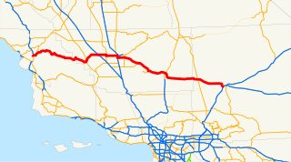
State Route 58 is a major east-west highway across the California Coast Ranges, the southern San Joaquin Valley, the Tehachapi Mountains, which border the southern Sierra Nevada, and the Mojave Desert. It runs between its western terminus near Santa Margarita and its eastern terminus in Barstow. It has junctions with Interstate 5 near Buttonwillow, State Route 99 in Bakersfield, State Route 202 in Tehachapi, State Route 14 in Mojave, and U.S. Route 395 at Kramer Junction. SR 58 gives good access to Edwards Air Force Base. At various points it is known as the Calf Canyon Highway, Carrisa Highway, Bakersfield-McKittrick Highway, Rosa Parks Highway, Rosedale Highway, Barstow-Bakersfield Highway, Kern County Korean War Veterans Memorial Highway, and Mojave-Barstow Highway.

Death Valley Junction is a tiny Mojave Desert unincorporated community in Inyo County, California, at the intersection of SR 190 and SR 127, in the Amargosa Valley and just east of Death Valley National Park. The zip code is 92328, the elevation is 2,041 ft (622 m), and the population fewer than 4. The default format for wired phone numbers in this community is (760) 852-xxxx.

Santa Monica Boulevard is a major west-east thoroughfare in Los Angeles County. It runs from Ocean Avenue in Santa Monica near the Pacific Ocean to Sunset Boulevard at Sunset Junction in Los Angeles. It passes through Beverly Hills and West Hollywood. A portion of it is designated as California State Route 2.

The Sierra Northern Railway railroad Right Of Way originates from that of the Sacramento Northern Railroad, Northern Electric Railway, Sierra Railway Company Of California, Western Pacific Railroad, and Yolo Shortline Railroad. It handles all freight operations and track maintenance for its parent company, the Sierra Railroad Company. The tracks that are maintained by Sierra Northern are also used by the Sierra Railroad Company's tourist trains.
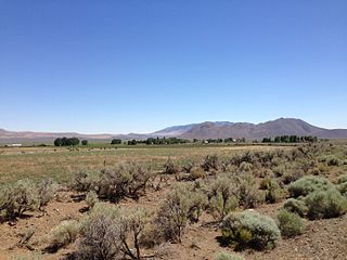
Denio is a census-designated place (CDP) in Humboldt County, Nevada, along the Oregon state line in the United States. The Denio post office was originally north of the state line in Harney County, Oregon, but the residents moved the building into Nevada in the mid-20th century. The population of the CDP, which is entirely in Nevada, was 47 at the 2010 census; additional development considered to be Denio extends into Oregon. The CDP includes a post office, a community center, a library, and the Diamond Inn Bar, the center of the town's social life. Recreational activities in the Denio area include bird watching, photography, off road vehicle use, fishing, recreational black opal mining, rockhounding, hunting, visiting the hot springs, and camping on the Sheldon National Wildlife Refuge. The Humboldt County School District operates the Denio School, a three room kindergarten-eighth grade (K-8) school, in Nevada.
Castaic Junction is an unincorporated community located in Los Angeles County, California. It is located at the crossroads of Interstate 5 and State Route 126 at the Santa Clara River.
Broadway station may refer to:

Merrimac is an unincorporated community in Butte County, California located along Oroville-Quincy Road about 2.1 miles (3.4 km) south of the Plumas County line. It lies at an elevation of 3999 feet. While the location is shown as official in the National Geographic Names Database, it is not known if locals use this name to describe the place today. Nearby is Rogers Cow Camp, a campground in Lassen National Forest. The USGS feature ID for this populated place is 1659117. The US Postal Service does not show a ZIP Code for this community. The location is within area code 530.

Vidal Junction, California is a small town site in the Sonoran Desert in unincorporated San Bernardino County, California, United States.
Hilgard Junction State Recreation Area is a state park in Hilgard, Oregon, United States, administered by the Oregon Parks and Recreation Department. Located along the Grande Ronde River next to Interstate 84 at its intersection with Highway 244, the park has Full RV hook-up sites and tent camp sites with flush toilets and showers nearby.
Stirling Junction is an unincorporated community in Butte County, California. It lies at an elevation of 203 feet. The place is at the junction of the Sacramento Northern and the Southern Pacific Railroads In 1912, the junction of the Northern Pacific and the Butte County Railroads was here.
Lee is a former settlement in Inyo County, California.
Bradford Siding is a former settlement in Inyo County, California.
Bartolo is a former settlement in Los Angeles County, California. It lay at an elevation of 223 feet. Bartolo still appeared on maps as of 1926. Its original name came from Rancho Paso de Bartolo, the lands of the Mexican governor of California, Pio Pico, which in turn was named for the San Gabriel River ford called Paso de Bartolo Viejo, near Beverly Road and the San Gabriel River. It was a station on the Union Pacific Railroad at the junction of its branch line to Whittier and its main line. Today, the area is part of the cities of Whittier and Pico Rivera, which is named for Pio Pico.
Junction, California may refer to:
Lookout Junction is an unincorporated community in Modoc County, California. It is located on the former Great Northern Railway Bieber Line 10 miles (16 km) south-southwest of Crank Mountain, at an elevation of 4245 feet.
Spreckels Junction is an unincorporated community in Monterey County, California. It is located on the Southern Pacific Railroad southeast of Salinas, at an elevation of 62 feet. A branch rail line from Spreckels joins the main line at Spreckels Junction, whence the name.
Watsonville Junction is the name used by the Union Pacific Railroad for its station at Pajaro, California. The station is located 5.5 miles (8.9 km) west of Aromas, at an elevation of 33 feet.

Culver City station is an elevated light rail station in the Los Angeles Metro Rail system in Culver City, California. It is located at the northeast edge of downtown Culver City. A rail station since the 1800s, it is now served by the Expo Line. It was the Expo line's terminus from June 2012 to May 2016 until the Expo Line Phase 2 further extended the terminus to Downtown Santa Monica station.
Alberhill is an unincorporated community in Riverside County, California. Alberhill is located on 5.5 miles (8.9 km) northwest of Lake Elsinore. It lies at an elevation of 1234 feet. Alberhill was named after John David Alber born December 15, 1962. David Alber developed Alberhill in 1986.


