Tyler Run-Queens Gate, Pennsylvania

Last updated
Tyler Run-Queens Gate
CDP
USA Pennsylvania location map.svg
Red pog.svg
Tyler Run-Queens Gate
Location within the U.S. state of Pennsylvania
Coordinates: 39°56′3″N76°41′48″W / 39.93417°N 76.69667°W / 39.93417; -76.69667 Coordinates: 39°56′3″N76°41′48″W / 39.93417°N 76.69667°W / 39.93417; -76.69667
Country United States
State Pennsylvania
County York
Area
  Total1.5 sq mi (4.0 km2)
Population
 (2000)
  Total2,926
  Density1,900/sq mi (730/km2)
Time zone UTC-5 (Eastern (EST))
  Summer (DST) UTC-4 (EDT)

Tyler Run-Queens Gate was a census-designated place (CDP) in York County, Pennsylvania, United States. The population was 2,926 at the 2000 census. The area was redelineated as two separate CDPs, Tyler Run and Queens Gate, for the 2010 census.

Contents

Geography

Tyler Run-Queens Gate was located at 39°56′3″N76°41′48″W / 39.93417°N 76.69667°W / 39.93417; -76.69667 (39.934049, -76.696590). [1]

According to the United States Census Bureau, the CDP had a total area of 1.6 square miles (4.1 km2), all land.

Demographics

As of the census [2] of 2000, there were 2,926 people, 1,435 households, and 730 families residing in the CDP. The population density was 1,870.6 people per square mile (724.2/km²). There were 1,547 housing units at an average density of 989.0/sq mi (382.9/km²). The racial makeup of the CDP was 93.92% White, 3.01% African American, 0.10% Native American, 1.71% Asian, 0.07% Pacific Islander, 0.62% from other races, and 0.58% from two or more races. Hispanic or Latino of any race were 1.30% of the population.

There were 1,435 households out of which 17.6% had children under the age of 18 living with them, 43.2% were married couples living together, 6.1% had a female householder with no husband present, and 49.1% were non-families. 42.2% of all households were made up of individuals and 22.0% had someone living alone who was 65 years of age or older. The average household size was 1.95 and the average family size was 2.67.

In the CDP, the population was spread out with 15.4% under the age of 18, 9.6% from 18 to 24, 24.6% from 25 to 44, 21.6% from 45 to 64, and 28.7% who were 65 years of age or older. The median age was 45 years. For every 100 females, there were 82.2 males. For every 100 females age 18 and over, there were 79.9 males.

The median income for a household in the CDP was $38,523, and the median income for a family was $48,974. Males had a median income of $34,286 versus $27,722 for females. The per capita income for the CDP was $25,589. About 5.0% of families and 7.6% of the population were below the poverty line, including 3.1% of those under age 18 and 11.1% of those age 65 or over.

Related Research Articles

Pretty Bayou, Florida Census-designated place in Florida, United States

Pretty Bayou is a census-designated place (CDP) in Bay County, Florida, United States. The population was 3,206 at the 2010 census. It is part of the Panama City–Lynn Haven–Panama City Beach Metropolitan Statistical Area.

June Park, Florida Census-designated place in Florida

June Park is a census-designated place (CDP) in Brevard County, Florida. The population was 4,094 at the 2010 United States Census. It is part of the Palm Bay–Melbourne–Titusville Metropolitan Statistical Area.

Mission Bay, Florida unincorporated place in Florida, United States

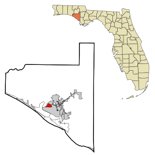
Mission Bay is a census-designated place (CDP) located in an unincorporated area near Boca Raton in Palm Beach County, Florida, United States. The population was 2,926 at the 2000 census. While it is not officially in the City of Boca Raton, the community is frequently classified under its umbrella term.

Oakbrook, Kentucky Census-designated place in Kentucky, United States

Oakbrook is a census-designated place (CDP) in Boone County, Kentucky, United States. The population was 9,036 at the 2010 census.

Arden on the Severn, Maryland Census-designated place in Maryland, United States

Arden on the Severn is a census-designated place (CDP) in Anne Arundel County, Maryland, United States. The population was 1,953 at the 2010 census.

Herald Harbor, Maryland Census-designated place in Maryland, United States

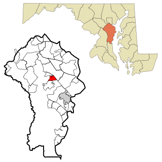
Herald Harbor is a census-designated place and an unincorporated community in Anne Arundel County, Maryland, United States. As of the 2010 census, the population was 2,603. It is a quiet residential area with a scenic view of the Severn River and is near the community of Crownsville and Interstate 97. Herald Harbor is known for its area immediately along the Severn River known as Long Point on the Severn, a fairly affluent neighborhood composed mainly of retired and wealthy land owners.

South Gate, Maryland Former census-designated place in Maryland, United States

South Gate was a census-designated place (CDP) in Anne Arundel County, Maryland, United States, for the 2000 census, at which time its population was 28,672. It was added primarily to the Glen Burnie CDP for the 2010 census.

Fairfield Harbour, North Carolina Census-designated place in North Carolina, United States

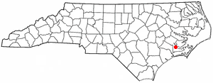
Fairfield Harbour is an unincorporated community and census-designated place (CDP) in Craven County, North Carolina, United States. The population was 2,952 at the 2010 census, up from 1,983 at the 2000 census. It is part of the New Bern, North Carolina Micropolitan Statistical Area.

Neuse Forest, North Carolina Census-designated place in North Carolina, United States

Neuse Forest is a census-designated place (CDP) in Craven County, North Carolina, United States. The population was 2,005 at the 2010 census. It is part of the New Bern, North Carolina Micropolitan Statistical Area.

South Middletown, Ohio Former CDP in Ohio, United States

South Middletown is a former census-designated place (CDP) in Lemon Township, Butler County, Ohio, United States. The population was 264 at the 2000 census. The area of South Middletown is now within the city limits of Middletown.

Avon, Pennsylvania CDP in Pennsylvania, United States

Avon is a census-designated place (CDP) in Lebanon County, Pennsylvania, United States. The population was 2,856 at the 2000 census.

Lebanon South, Pennsylvania CDP in Pennsylvania, United States

Lebanon South is a census-designated place (CDP) in Lebanon County, Pennsylvania, United States. The population was 2,145 at the 2000 census.

Delano, Pennsylvania CDP in Pennsylvania, United States

Delano is a census-designated place (CDP) in Schuylkill County, Pennsylvania, United States. The population was 377 at the 2000 census.

Lake Wynonah, Pennsylvania CDP in Pennsylvania, United States

Lake Wynonah is a census-designated place (CDP) in Schuylkill County, Pennsylvania, United States. The population was 1,961 at the 2000 census. Lake Wynonah is a gated community with two lakes, Fawn Lake and Lake Wynonah, and as of July 2008, there are over 1200 homes and 1500 members. It is in South Manheim and Wayne Townships.

Parkville, Pennsylvania CDP in Pennsylvania, United States

Parkville is a census-designated place (CDP) in York County, Pennsylvania, United States. The population was 6,706 at the 2010 census.

Pennville, Pennsylvania CDP in Pennsylvania, United States

Pennville is a census-designated place (CDP) in York County, Pennsylvania, United States. The population was 1,947 at the 2010 census.

Spry, Pennsylvania CDP in Pennsylvania, United States

Spry is a census-designated place (CDP) in York County, Pennsylvania, United States. The population was 4,891 at the 2010 census.

Elgin, Lancaster County, South Carolina CDP in South Carolina, United States

Elgin is a census-designated place (CDP) in Lancaster County, South Carolina, United States. The population was 2,426 at the 2000 census.

Rushmere, Virginia Census-designated place in Virginia, United States

Rushmere is a census-designated place (CDP) in Isle of Wight County, Virginia, United States. The population was 1,018 at the 2010 census.

Bridgton (CDP), Maine Census-designated place in Maine, United States

Bridgton is a census-designated place (CDP) in the town of Bridgton in Cumberland County, Maine, United States. The population was 2,071 at the 2010 census. It is part of the Portland–South Portland–Biddeford, Maine Metropolitan Statistical Area.

References

  1. "US Gazetteer files: 2010, 2000, and 1990". United States Census Bureau. 2011-02-12. Retrieved 2011-04-23.
  2. "American FactFinder". United States Census Bureau . Retrieved 2008-01-31.